
Program Overview
The Water Quality Planning Bureau carries out a water quality planning process to protect water quality in Montana. This includes:
- Developing water quality standards to protect the beneficial uses of Montana’s waters.
- Monitoring water quality to collect data and compare to the water quality standards.
- Identifying sources of pollution and developing total maximum daily loads to determine reductions needed from identified sources of pollution to meet water quality standards.
- Supporting water quality protection practices.
Found on this page are summaries of water quality planning projects that are in one of the above phases of planning. Note that this is not an all-inclusive list of work ongoing within the bureau.
Water Quality Planning Projects Contact
General questions
Water Quality Planning Bureau Chief
Andy Ulven (406) 444-2680
Refer to the contact associated with the water quality planning project for project-specific questions. For general questions, contact us using the information above.
Active Projects
Active projects are projects in an active phase of, or some combination of, the following: water quality standards development, monitoring and assessment, or total maximum daily load development.
Beaverhead Nutrient TMDLs
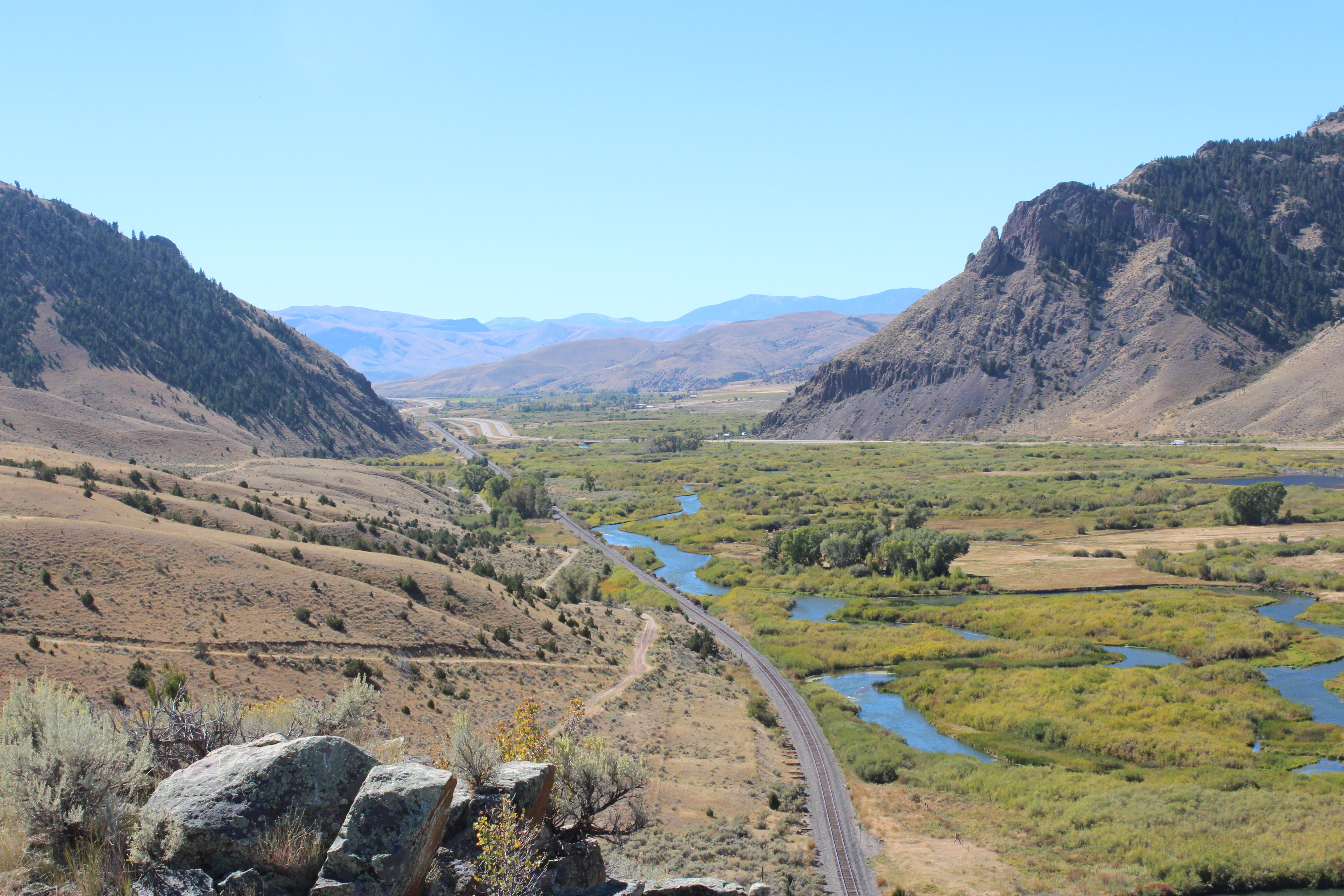
The majority of the Beaverhead TMDL Planning Area (TPA) is located within Beaverhead County, with a small portion in Madison County and includes the towns of Dillon and Twin Bridges. The Beaverhead TPA encompasses the Beaverhead River watershed, which begins at the outlet of the Clark Canyon Reservoir and flows northeast 79.5 miles before joining the Big Hole River to form the Jefferson River. The TPA coincides with the 10020002 fourth-code hydrologic unit code (HUC), and is bounded by the Pioneer Mountains on the west, the Ruby Range to the east, and the Snowcrest Range and Blacktail Mountains to the south.
Since the conclusion of water quality monitoring projects, three TMDL documents have been published that address multiple streams and pollutant types within the Beaverhead TPA. Nutrient TMDLs, however, are still in development.
DEQ has completed several years of water quality sampling for sediment, temperature, nutrients, and metals in cooperation with the Beaverhead Watershed Committee and others.
Through this monitoring efforts, the Montana Department of Environmental Quality has identified 15 streams or assessment units with nutrient water quality impairments in the Beaverhead TPA. They are shown in the table below. The TMDL planning process for this TPA incorporates a combination of water quality sampling and hydrologic modeling to further identify and quantify nutrient contributions from all significant sources.
The following table identifies which streams have nutrient listed impairments. For complete information on each stream's probable impairment causes and sources, see DEQ's Clean Water Act Information Center.
| Assessment Unit | Assessment Unit ID | Nutrient Impairments: 2020 Integrated Report |
|---|---|---|
| Beaverhead River, Clark Canyon Dam to Grasshopper Creek | MT41B001_010 | Total Nitrogen, Total Phosphorus |
| Beaverhead River, Grasshopper Creek to mouth | MT41B001_020 | Total Nitrogen, Total Phosphorus |
| Blacktail Deer Creek, headwaters to mouth | MT41B002_030 | Total Nitrogen |
| Clark Canyon Creek, headwaters to mouth | MT41B002_110 | Total Phosphorus |
| Dyce Creek, confluence of East and West Forks to mouth | MT41B002_140 | Total Nitrogen, Total Phosphorus |
| Grasshopper Creek, headwaters to mouth | MT41B002_010 | Total Nitrogen, Total Phosphorus |
| Rattlesnake Creek, headwaters to Dillon PWS off-channel well, T7S R10W S11 | MT41B002_120 | - |
| Rattlesnake Creek, Dillon PWS off-channel well, T7S R10W S11, to mouth | MT41B002_091 | Total Nitrogen, Total Phosphorus |
| Reservoir Creek, headwaters to mouth | MT41B002_120 | Total Nitrogen, Total Phosphorus |
| Scudder Creek, headwaters to mouth | MT41B002_180 | Total Nitrogen |
| Spring Creek, headwaters to mouth | MT41B002_080 | Total Nitrogen, Total Phosphorus |
| Steel Creek, headwaters to mouth | MT41B002_160 | Total Nitrogen, Total Phosphorus |
| Stone Creek, Left and Middle Fork to un-named tributary | MT41B002_132 | Total Nitrogen, Nitrate + Nitrite, Total Phosphorus |
| Stone Creek, Un-named tributary to Staudaher Bishop Ditch | MT41B002_131 | Total Nitrogen, Nitrate + Nitrite, Total Phosphorus |
| Taylor Creek, headwaters to mouth | MT41B002_170 | Total Nitrogen, Total Phosphorus |
| Wellman Creek, headwaters to mouth | MT41B002_150 | - |
| West Fork Dyce Creek, headwaters to mouth | MT41B002_070 | Total Nitrogen |
| West Fork Blacktail Deer Creek, headwaters to mouth | MT41B002_060 | - |
After a waterbody is listed as impaired for any pollutant, a total maximum daily load (TMDL) is calculated for that waterbody-pollutant combination. TMDLs represent the maximum amount of a pollutant that can enter a waterbody without exceeding the water quality standard. In addition, TMDL documents give specific recommendations for best management practices in order to meet the TMDL value.
Nutrient TMDLs are currently awaiting development based on listings in the 2020 Integrated Report.
Sediment TMDLs were completed in July of 2012. A temperature TMDL was developed for the lower segment of the Beaverhead River in November of 2014. Metals TMDLs were completed in September of 2020. The final documents can be found on DEQ's TMDL page.
DEQ has completed several years of water quality sampling for sediment, temperature, nutrients, and metals in cooperation with the Beaverhead Watershed Committee and others.
Additional information will be provided as Nutrient TMDLs progress.
| Name | Role | Phone | |
|---|---|---|---|
| Troy Clift | Nutrient TMDL Project Manager, TMDL Section | troy.clift@mt.gov | (406) 444-2409 |
| Christina Staten | TMDL Section Supervisor | cstaten@mt.gov | (406) 444-2836 |
Big Hole River
DEQ is currently conducting water quality planning work in the Big Hole River watershed, including:
-
Supporting restoration projects
-
Funding volunteer water quality monitoring projects
-
Monitoring undesirable algae blooms
-
Updating water quality assessments for the mainstem of the river
-
Evaluating water quality improvement progress on the tributaries in a total maximum daily load (TMDL) implementation evaluation
-
Monitoring sediment conditions in French Creek to track positive changes in response to restoration activities
Information on each topic can be found below.
The Big Hole River watershed (fourth-code hydrologic unit code 10020004) encompasses approximately 1,786,146 acres (2,791 square miles) in Beaverhead, Deer Lodge, Silver Bow, and Madison counties in southwest Montana. The mainstem of the Big Hole River flows through the towns of Jackson, Wisdom, Fishtrap, Wise River, Dewey, Divide, Melrose, and Glen, Montana. The mainstem Big Hole River is composed of three assessment units: the lower, middle, and upper Big Hole River (Figure 1).
Montana DEQ assesses waterbodies based on assessment units. Assessment units are delineations of surface waters specifically used to track and report on water quality assessment results and are the smallest unit of a waterbody for which a determination of water quality impairment is made. An assessment unit may consist of an entire waterbody or segment of a waterbody, the length of which is determined based on multiple factors including but not limited to beneficial uses, surrounding land use, watershed boundaries, and geomorphology.
The three assessment units on the mainstem Big Hole River are referred to as the Upper, Middle, and Lower Big Hole River. The Upper Big Hole River extends 65.2 miles from the headwaters to the confluence with Pintlar Creek. The Middle Big Hole River extends 43.8 miles from the confluence of Pintlar Creek downstream to the confluence with Divide Creek. Finally, the Lower Big Hole River extends 51.4 miles from Divide Creek to the mouth, where the Big Hole River meets the Beaverhead River to form the Jefferson River.
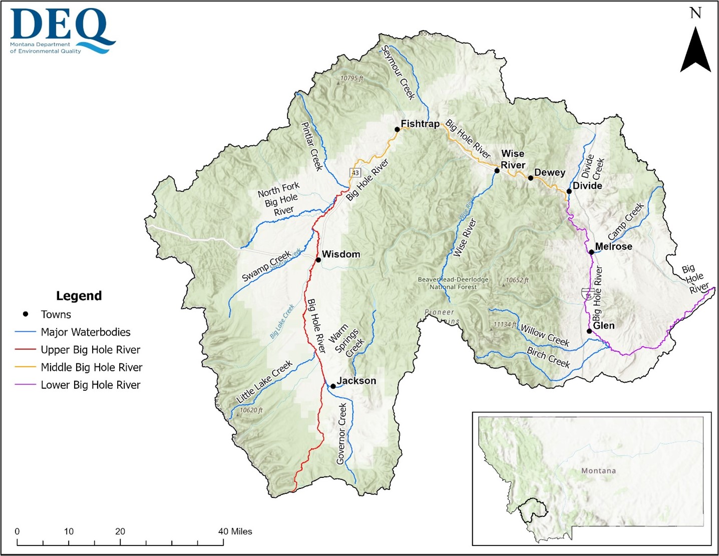
Figure 1. Big Hole River watershed.
Though Department of Environmental Quality (DEQ) work in the Big Hole watershed dates back to 1988, recent DEQ supported monitoring projects in the watershed began in 2020. Monitoring has included nutrients (nitrogen and phosphorus), algae, macroinvertebrates (aquatic insects), sediment, temperature, dissolved oxygen, pH and metals.
Monitoring has been completed by DEQ and local watershed groups. Table 1 provides a list of the parameters monitored and which organizations contributed.
DEQ updated assessment records for seven streams or assessment units in the Big Hole watershed as part of the draft combined 2022-2024 Integrated Report, Table 2.
DEQ has recently performed a draft eutrophication and dissolved oxygen assessment to determine if the Big Hole River is meeting water quality standards and supporting beneficial uses. DEQ determined eutrophication and dissolved oxygen are impacting aquatic life and recreational uses in the Big Hole River. The primary stressors to the river related to eutrophication include excess algal growth (Figure 2), degraded aquatic insect communities, high pH, and low dissolved oxygen. Information on these determinations provided during a public open house on June 23, 2026, in Divide is provided in the Documents and Reports section. The public will be able to provide feedback and additional data related to the assessment decision during public comment for the draft 2026 Water Quality Integrated Report when it is released. DEQ will post to the Water Quality Public Comment webpage when public comment opens. Once assessments are finalized, a table of the water quality impairments will be posted to this page.
For further assessment information contact Abbie.Ebert@mt.gov.
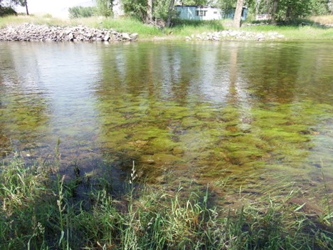
Figure 2. Algae growth in the Big Hole River at Glen (June 2023).
| Parameter | Organization | DEQ Funds Committed |
|---|---|---|
| Algae | DEQ and Save Wild Trout | Yes |
| Aquatic Insects (Macroinvertebrates) | DEQ and Save Wild Trout | Yes |
| Dissolved Oxygen and pH | Save Wild Trout and Big Hole Watershed Committee | No |
| Nutrients* | Save Wild Trout | Yes |
| Metals** | Big Hole Watershed Committee | Yes |
| Assessment Unit | Assessment Unit ID | Draft 2022-2024 Integrated Report Assessment Outcomes* |
|---|---|---|
| Big Hole River, headwaters to Pintlar Creek | MT41D001_030 | pH impairment |
| Big Hole River, Pintlar Creek to Divide Creek | MT41D001_020 | pH impairment |
| Big Hole River, Divide Creek to mouth (Jefferson River) | MT41D001_010 | pH impairment |
| North Fork Big Hole River, headwaters to mouth (Big Hole River) | MT41D004_010 | pH impairment |
| Deep Creek, headwaters to mouth (Big Hole River) | MT41D003_040 | pH impairment |
| Wise River, headwaters to mouth (Big Hole River) | MT41D003_200 | pH impairment |
| Elkhorn Creek, headwaters to mouth (Jacobson Creek) | MT41D003_220 | Arsenic and lead removed as an impairment |
| Elkhorn Creek, headwaters to mouth (Jacobson Creek) | MT41D003_220 | Cadmium, copper, and zinc impairments still listed |
| Elkhorn Creek, headwaters to mouth (Jacobson Creek) | MT41D003_220 | Do not list silver |
DEQ has provided over $1,350,590 in support for restoration and monitoring projects in the Big Hole River watershed. Restoration work has been conducted by numerous entities:
-
Big Hole Watershed Committee,
-
Montana Bureau of Land Management,
-
United States Forest Service, and
-
Montana Fish, Wildlife & Parks
Restoration work in the watershed has primarily focused on reducing sediment sources such as eroding streambanks, accelerated erosion of banks and riparian areas from livestock, and lack of vegetation in riparian areas on tributaries to the mainstem Big Hole River. These restoration projects have been monitored for pre- and post-implementation sediment loads to determine how much sediment was prevented from entering the waterbody.
DEQ has been supporting nutrient and algae monitoring conducted by Save Wild Trout since 2020. Data collected included nutrients, macroinvertebrates, aquatic plant visual assessments, and continuous dissolved oxygen. This data was used to assess the mainstem Big Hole River for eutrophication impacts.
The United States Geological Survey has operated streamflow gages in the Big Hole River watershed since 1994. These gages measure water flow and water temperature providing a long-term dataset that can help evaluate these trends over multiple decades.
Working and volunteering with local watershed groups, landowners and recreationists can reduce pollutant inputs within the watershed. Table 3 contains a list of volunteer organizations that you can get involved with.
| Organization | Contact Links |
|---|---|
| Big Hole Watershed Committee | https://bhwc.org/about/contact-us/ |
| Save Wild Trout | https://www.savewildtrout.net/join |
| Trout Unlimited | https://www.georgegranttu.org/contact-us/ |
After a waterbody is listed as impaired for a pollutant, a total maximum daily load (TMDL) is calculated for that waterbody-pollutant combination. TMDLs represent the maximum amount of a pollutant that can enter a waterbody before being considered impaired (not meeting water quality goals). Furthermore, TMDL documents give specific recommendations for water quality improvement practices to meet the TMDL’s water quality goals.
Two TMDL documents containing 91 TMDLs (waterbody-pollutant combinations) for the Big Hole River watershed were developed in 2009 to address nutrients, metals, sediment, and water temperature problems on various tributaries as well as the mainstem Big Hole River. The “Middle and Lower Big Hole Planning Area TMDLs and Water Quality Improvement Plan” and “Upper and North Fork Big Hole River Planning Area TMDLs and Framework Water Quality Restoration Approach” documents can be found on the TMDL Program webpage in the TMDL Documents section. Should the eutrophication impairment determinations for the Upper, Middle, and Lower Big Hole River and the dissolved oxygen impairment determinations for the Upper and Lower Big Hole River be approved by EPA in the 2026 Integrated Report, additionalTMDLs would be required for the Big Hole River. A timeline for TMDL development would be established in consultation with the Statewide TMDL Advisory Group after the 2026 Integrated Report is approved. This page will be maintained with up-to-date information about the progress of any TMDLs and TMDL documents.
In watersheds with approved TMDL documents, DEQ periodically reviews the progress of restoration efforts, evaluates whether TMDL water quality goals are progressing, and details the results in a document called a TMDL Implementation Evaluation (TIE). TIEs identify specific recommendations such as additional restoration projects needed, additional recommended monitoring, or the potential for reassessment of a waterbody. In June 2026, DEQ completed the draft Big Hole River TMDL Implementation Evaluation, available on the TMDL Program website in the TMDL Implementation Evaluations section.
| Type | Date | Time | Location | Meeting Materials |
|---|---|---|---|---|
| Open House | June 23, 2026 | 4:00-7:00 pm | Divide Grange Hall (105 Schoolhouse Road Divide, MT 59727) | Posters |
| Name | Role | Phone | |
|---|---|---|---|
| Abbie Ebert | Monitoring and Assessment Project Manager | Abbie.Ebert@mt.gov | (406) 444-5390 |
| Darrin Kron | Monitoring and Assessment Section Supervisor | DKron@mt.gov | (406) 444-4765 |
| Kyle Milke | TMDL Implementation Evaluation Project Manager | Kyle.Milke@mt.gov | (406) 444-6491 |
| Christina Staten | TMDL Section Supervisor | CStaten@mt.gov | (406) 444-2836 |
Clarks Fork of the Yellowstone
The Clarks Fork Yellowstone TMDL Planning Area (TPA) is contained within Carbon County. Towns in the watershed include Red Lodge, Belfry, Bridger, Fromberg, Edgar, and Joliet. The Clarks Fork Yellowstone project area encompasses the area shown in Figure 1.
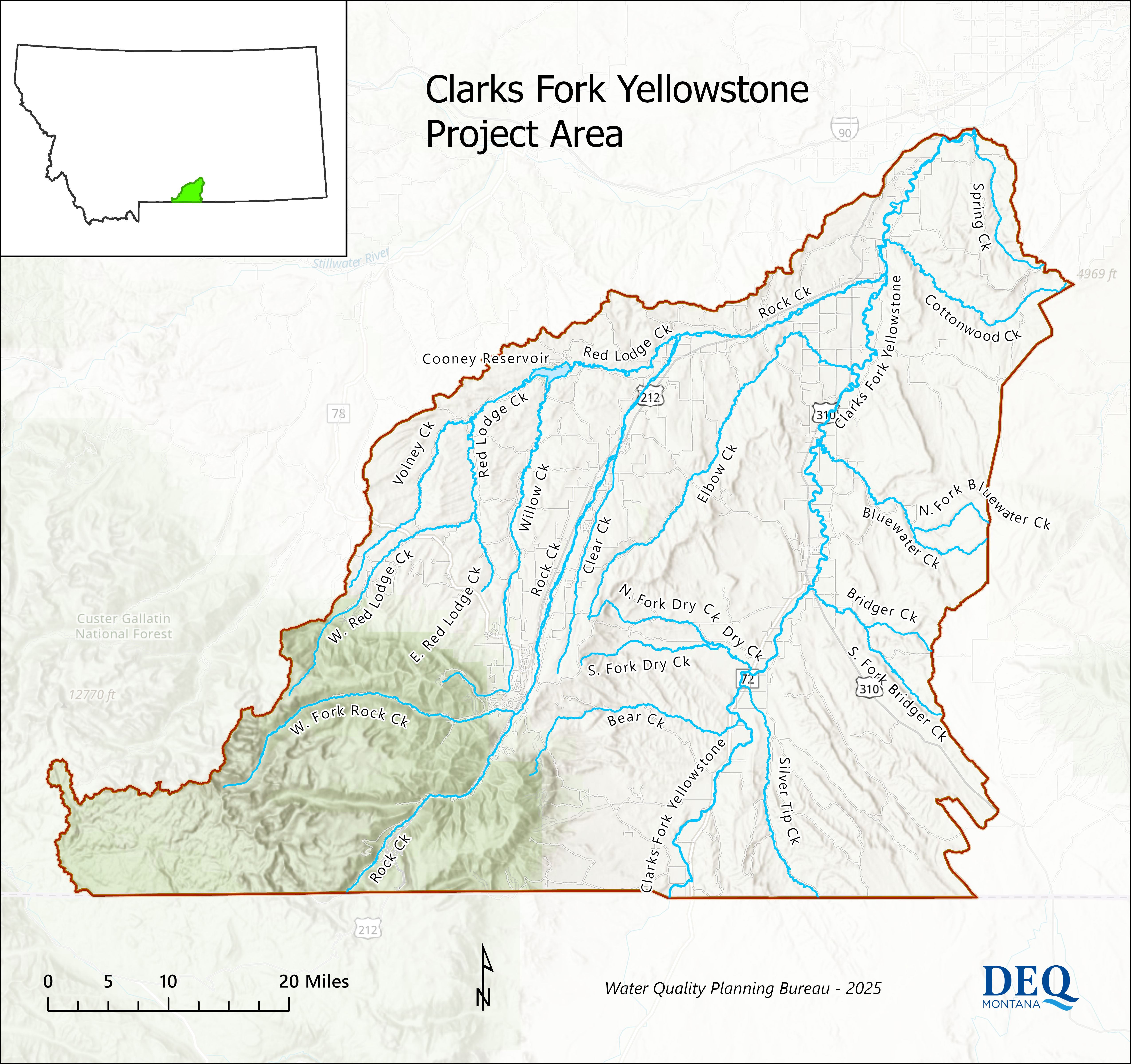
Figure 1. Clarks Fork Yellowstone TMDL Planning Area
The Clarks Fork of the Yellowstone River originates in the Beartooth Mountains at the confluence of Fisher Creek and Lady of the Lake Creek, in Park County, Montana. From there, the river flows south past Cooke City. After crossing into Wyoming, the river begins to meander eastward. Once the Clarks Fork of the Yellowstone leaves the Shoshone National Forest, it flows north and returns to Montana near Chance, MT.
The Clarks Fork Yellowstone watershed coincides with the 10070006 fourth-code hydrologic unit code (HUC). The watershed is bounded by the Beartooth Mountains and Stillwater watershed to the west, the Ralston Flats to the south, and the Pryor Mountains and Pryor Creek watershed to the east. One reservoir is in the watershed along Red Lodge Creek (Cooney Reservoir). The total extent of the watershed is 942,469 acres, or approximately 1,472 square miles. This TMDL Planning (TPA) project includes the portion of the watershed after it re-enters Montana from Wyoming (Figure 1).
The water quality monitoring project was initiated in 2022 and will continue through 2025. The project is designed to complete beneficial use assessments, TMDL development, and restoration efforts. Monitoring is occurring on the mainstem of the Clarks Fork Yellowstone River, Rock Creek, 16 additional tributaries, and Cooney Reservoir.
DEQ is monitoring the Clarks Fork Yellowstone River, 16 of its tributaries, and Cooney Reservoir for a variety of parameters including nutrients, metals, E. coli, sediment, and oil and gas constituents. The monitoring design was informed by past impairment listings, watershed risk analysis, and stakeholder feedback. Monitoring for nutrients, metals, algae, and oil and gas parameters was completed in 2024. Sediment and habitat monitoring will occur during summer 2025. After monitoring is complete, DEQ will perform beneficial use assessments to identify water quality impairments, or waters that are not meeting water quality standards. Once assessments are complete, a table of the water quality impairments will be posted to this page.
Data can be downloaded from the National Water Quality Portal or requested from the project manager (Abbie Ebert).
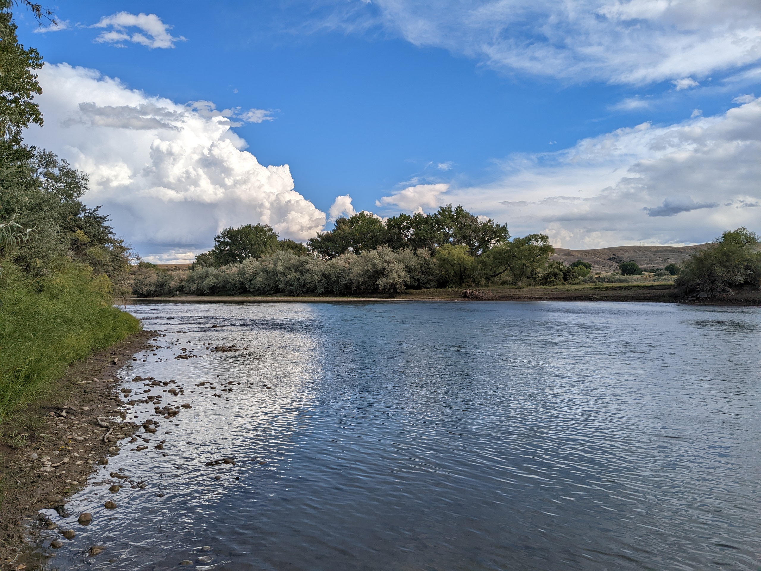
Table of Waterbodies and Associated Pollutants Monitored
X = the waterbody is being monitored for this pollutant group.
Nutrients may include variants of nitrogen and phosphorus.
Metals may include aluminum, arsenic, cadmium, chromium, copper, iron, lead, selenium, silver, and zinc.
| Waterbody | Nutrients | Sediment | Metals | Algae | Macroinvertebrates | E.coli | Continuous Dissolved Oxygen | Oil and Gas Parameters |
|---|---|---|---|---|---|---|---|---|
| Bear Creek | X | X | X | X | X | X | ||
| Bluewater Creek | X | X | X | X | X | X | ||
| Bridger Creek | X | X | X | X | X | X | ||
| Clarks Fork Yellowstone River | X | X | X | X | X | X | X | |
| Clear Creek | X | X | ||||||
| Cooney Reservoir | X | X | X | X | ||||
| Dry Creek | X | X | ||||||
| Elbow Creek | X | X | X | X | X | X | ||
| North Fork Dry Creek | X | X | ||||||
| Red Lodge Creek | X | X | X | X | X | X | ||
| Rock Creek | X | X | X | X | X | X | X | |
| Silvertip Creek | X | X | X | X | X | X | X | |
| South Fork Bridger Creek | X | X | X | X | X | X | ||
| South Fork Dry Creek | X | X | X | |||||
| Spring Creek | X | X | ||||||
| Volney Creek | X | X | X | |||||
| West Red Lodge Creek | X | X | X | X | X | X | ||
| Willow Creek | X | X | X | X | X | X |
After a waterbody is listed as impaired for any pollutant, a total maximum daily load (TMDL) is calculated for that waterbody-pollutant combination. TMDLs represent the maximum amount of a pollutant that can enter a waterbody without exceeding the water quality standard. In addition, TMDL documents give specific recommendations for best management practices in order to meet the TMDL value.
TMDLs will be developed for the Clarks Fork Yellowstone River watershed; however, a timeline for completion has not yet been developed. This information will be updated once water quality assessments are complete.
TMDLs have been completed for the headwaters of the Clark’s Fork of the Yellowstone River and can be found in the Water Quality Restoration Plan for the Cooke City TMDL Planning Area document.
| Meeting | Date | Location | Meeting Materials |
|---|---|---|---|
| Public Meeting: Overview of Clarks Fork Yellowstone Watershed Water Quality Monitoring Project | 6/9/2022 | Joliet |
Provided an overview of DEQ's water quality monitoring project plan from 2022-2024. |
| Public Meeting: Clarks Fork Yellowstone Water Quality Monitoring Project Updates - 2022 Sampling Results | 2/16/2023 | Joliet |
Provide a summary of 2022 water quality monitoring results and update on sampling plans for 2023. |
| Public Meeting: Clarks Fork Yellowstone Water Quality Monitoring Project Updates - 2023 East Side Sampling Results | 4/24/2024 | Bridger |
Provide a summary of 2023 water quality monitoring results for the east side of the watershed and update on sampling plans for 2024. |
| Public Meeting: Clarks Fork Yellowstone Water Quality Monitoring Project Updates - 2023 West Side Sampling Results | 4/25/2024 | Joliet |
Provide a summary of 2023 water quality monitoring results for the west side of the watershed and update on sampling plans for 2024. |
| Document | Description | Date |
|---|---|---|
| Watershed water quality project plan outlining monitoring and assessment work, TMDL Implementation, and water quality improvements. | June 2022 | |
| Detailed plan describing the monitoring to be completed in 2022 and analysis work that will follow. | June 2022 | |
| Detailed plan describing the monitoring to be completed in 2023 and analysis work that will follow. | June 2023 | |
| Detailed plan describing the monitoring to be completed in 2024 and analysis work that will follow. | April 2024 |
| Name | Role | Phone | |
|---|---|---|---|
| Abbie Ebert | Monitoring and Assessment Project Manager | Abbie.Ebert@mt.gov | (406) 444-5390 |
| Darrin Kron | Monitoring and Assessment Section Supervisor | DKron@mt.gov | (406) 444-4765 |
| Troy Clift | Cooney Reservoir TMDL Project Manager | Troy.Clift@mt.gov | (406) 444-2409 |
| Christina Staten | TMDL Section Supervisor | CStaten@mt.gov | (406) 444-2836 |
| Mark Ockey | Nonpoint Source and Wetlands Section | Mockey@mt.gov | (406) 444-5351 |
| Organization | Phone | Website | |
|---|---|---|---|
| Clarks Fork Yellowstone Partnership | cfypwatershed@gmail.com | 406-425-2127 | https://cfypwatershed.org/ |
| Carbon County Resource Council | jackson@northernplains.org | 406-248-1154 | https://northernplains.org/affiliates/carbon-county-resource-council/ |
| Carbon Conservation District | Carboncd@macdnet.org | 406-962-3641 ext. 105 | https://www.carboncd.org/ |
| Natural Resources Conservation District | krist.walstad@usda.gov | 406-962-3641 | https://www.nrcs.usda.gov/state-offices/montana |
Flathead-Stillwater (Ashley Creek) TMDL Revisions
In 2014, EPA approved the Flathead-Stillwater Planning Area Nutrient, Sediment, and Temperature TMDLs and Water Quality Improvement Plan, which included nutrient and sediment TMDLs for Ashley Creek and nutrient TMDLs for Spring Creek (a tributary of Ashley Creek). The initial TMDL development effort included use of a water quality model to provide a better understanding of pollutant loading in the Flathead Lake watershed. However, nutrient loading in the Ashley Creek watershed was less understood and additional nutrient data collection occurred after approval of the TMDLs. Subsequently, the model was updated to incorporate the new data on Ashley Creek which resulted in revised loading estimates. Therefore, the Ashley Creek and Spring Creek TMDLs are being revised to reflect the updated model results. The specific TMDLs being revised are shown below in Table 1. The TMDL revisions will undergo public comment and will be subject to EPA approval.

Figure 1. Impaired waterbodies in the Ashley Creek basin.
| Waterbody and Location Description | TMDL(s) Being Revised |
|---|---|
|
Ashley Creek Ashley Lake to Smith Lake |
Total Nitrogen, Sediment |
|
Ashley Creek Smith Lake to Kalispell Airport Road |
Total Nitrogen, Total Phosphorus, Sediment |
|
Ashley Creek Kalispell Airport Road to mouth (Flathead River) |
Total Nitrogen, Total Phosphorus, Sediment |
|
Spring Creek headwaters to mouth (Ashley Creek) |
Total Nitrogen, Total Phosphorus |
In 2015, DEQ conducted additional water sampling along Ashley Creek to better understand nutrient and sediment loads above and below Smith Lake, a lake-wetland complex that denotes the end of upper Ashley Creek. Using the new data and updated model parameters, DEQ revised the pollutant loading models for the Ashley Creek basin in 2022 to improve the accuracy of source assessment. Using the new model output, DEQ is now revising several TMDLs for Ashley and Spring creeks (Table 1). The revisions changed source allocations for nutrients and sediment, slightly altered the existing loading of nutrients in Ashley Creek, and improved model calibration metrics.
In the “Documents and Reports” dropdown below, you can find the sampling and analysis plan for the nutrient and flow sampling conducted in the Ashley Creek watershed in 2015 as well as a summary report from 2016. All collected data are available at the National Water Quality Portal.
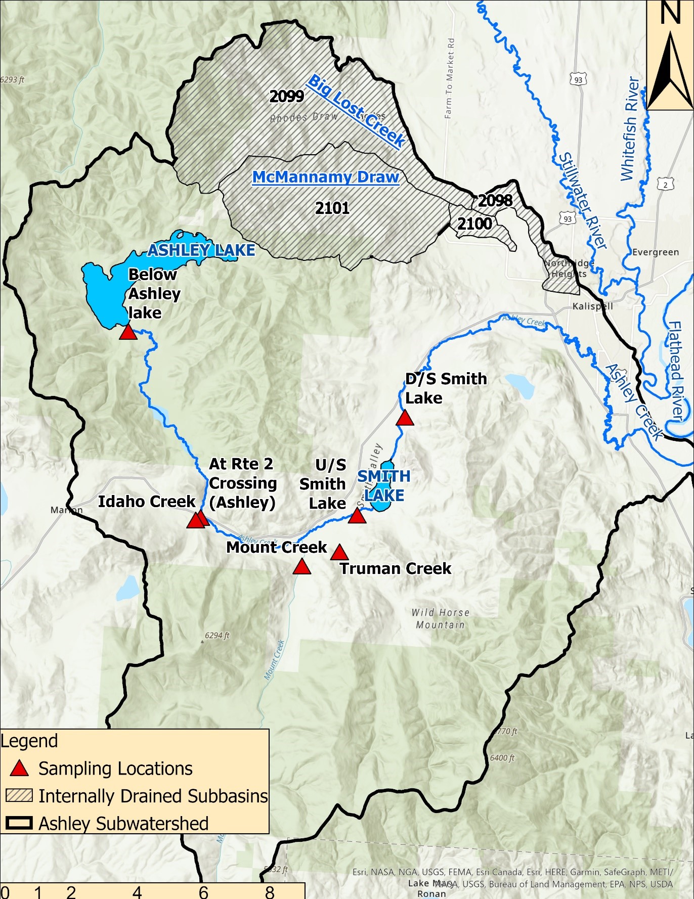
Figure 1. Sites sampled on Ashley Creek during 2015.
| Document | Description | Version and Date |
|---|---|---|
| 2015 Water Quality Sampling and Action Plan | Sampling and Action Plan for the extra monitoring on Ashley Creek in 2015. | Final (2015) |
| 2015 Sampling Summary Report | Results and summary of 2015 sampling on Ashley Creek. | Final (2015) |
| Revised Modeling Report | Detailed changes to the model underlying Ashley Creek source assessment. | Will be available when the revision is in the public comment phase. |
| Name | Role | Phone | |
|---|---|---|---|
| Joe Vanderwall | TMDL Revision Project Manager | joseph.vanderwall@mt.gov | (406) 444-4071 |
| Christina Staten | TMDL Section Supervisor | CStaten@mt.gov | (406) 444-2836 |
| Katie Makarowski | Standards and Modeling Section Supervisor | kmkarowski@mt.gov | (406) 444-3639 |
Gallatin River (middle segment)
The middle segment of the Gallatin River (Assessment Unit: MT41H001_021) originates at the Yellowstone National Park Boundary, flowing 39.28 miles north to the confluence of Spanish Creek, and has portions of its watershed in Gallatin, Madison, and Park counties.
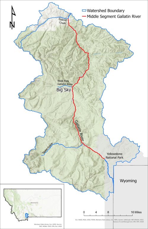
Map showing the spatial extent of the watershed for the middle segment of the Gallatin River and its location within Montana
Recurrent, filamentous algal blooms have been observed on this segment of the Gallatin River. On March 31st, 2022, DEQ received a petition to assess the middle segment of the Gallatin River and determine if recurrent undesirable algal blooms require listing as an impaired water on Montana’s 303(d) list. The petition provided photos and videos of algae growth on this segment along with testimonials of recreationalist and businesses that derive income based on recreation. After reviewing the evidence provided by this petition, DEQ determined there was sufficient credible data that indicates the segment is impaired due to excess algal growth under the Administrative Rules of Montana (ARM) 17.30.637(1)(e). The algae listing was included as an addendum to the 2020 Water Quality Integrated Report. However, the assessment also revealed the river is not impaired for nitrogen and phosphorus when compared to existing numeric criteria.
DEQ is devoting significant monitoring resources over three years, beginning in 2023, to further study the Gallatin River to determine thresholds for controllable pollutants and other factors that affect algae growth in the middle segment. This study will help determine causes and sources of algae growth. Project outcomes include writing appropriate total maximum daily loads (TMDLs) and guide future impairment listings.
Anticipated timelines for this project include completion of water quality monitoring in 2025, followed by development of a water quality model to determine the drivers of excess algal growth, and completion of TMDLs by 2028.
DEQ is conducting extensive water quality and algae monitoring that will continue through 2025. These efforts will facilitate updates to beneficial use assessment as well as bolster data collection for studying undesirable algal growth on the middle segment of the Gallatin River. The full suite of monitoring parameters is described in the table below.
This monitoring effort will allow DEQ to model algal growth and help determine when and why excess algae is proliferating within the middle segment of the Gallatin River. Outputs from these modeling efforts will be used to calculate a total maximum daily load (TMDL) for the pollutants responsible for algal growth.
Upon completion, algae study results will be available on this website. Water quality data collected during this monitoring effort will be available from the Water Quality Portal.
| Parameter(s) | 2023 | 2024 | 2025 |
|---|---|---|---|
|
Nutrients (nitrogen and phosphorus) |
X |
X |
X |
|
Hardness |
X |
X |
X |
|
Total suspended sediment and total dissolved solids |
X |
X |
X |
|
Benthic algae |
X |
X |
X |
|
Bioavailable sediment-bound phosphorus |
X |
|
|
|
Aerial drone flights to monitor algal density |
X |
X |
X |
|
Macroinvertebrates (bugs) |
X |
X |
X |
|
Continuous Data Loggers (Dissolved Oxygen, Temperature, pH, and Conductivity) |
X |
X |
X |
|
Streamside shade assessment |
X |
||
|
Discharge (stream flow) |
X |
X |
X |
After a waterbody is listed as impaired for any pollutant, a total maximum daily load (TMDL) is calculated for that waterbody-pollutant combination. TMDLs represent the maximum amount of a pollutant that can enter a waterbody and still meet the water quality standard. In addition, TMDL documents give specific recommendations for best management practices to meet the TMDL value.
TMDLs on the middle segment of the Gallatin River are a DEQ priority due to the river’s importance and should be completed by 2028. TMDLs will be completed for all pollutants determined to be contributing to the excess algal growth impairment. Additional information about the TMDL development process will be added once TMDL development begins.
| Meeting | Date | Location | Meeting Materials |
|---|---|---|---|
|
Gallatin River Water Quality Monitoring Project Public Meeting |
May 1, 2023 |
Big Sky Water & Sewer District office 561 Little Coyote Rd Big Sky, MT |
Intro and background on the study; plans for summer 2023 sampling. Presentation Materials (5/1/2023) |
|
Gallatin River Water Quality Monitoring Project Public Meeting |
April 22, 2024 |
Big Sky Water & Sewer District office 561 Little Coyote Rd Big Sky, MT |
Updates to study findings thus far; plans for summer 2024 sampling. Presentation Materials (4/22/2024) |
|
Gallatin River Open House |
July 29, 2025 |
Arts Council of Big Sky 77 Lone Peak Drive Big Sky, MT |
Updates to study findings thus far; 2025 sampling. Open House Posters (7/29/2025) |
| Document | Description | Version |
|---|---|---|
|
Explains Gallatin River impairment listing decision |
Final (March 2025) |
|
|
Nonpoint Source Pollution Reduction Efforts in the Gallatin Watershed |
Final (April 2023) |
| Name | Role | Phone | |
|---|---|---|---|
|
Gabrielle Metzner |
Water Quality Assessment Project Manager, Monitoring and Assessment Section |
Gabrielle.Metzner@mt.gov |
(406) 444-2709 |
|
Christy Meredith |
Algae Modeling Project Manager, Water Quality Standards and Modeling Section |
Christy.Meredith@mt.gov |
(406) 444-0371 |
|
Troy Clift |
TMDL Project Manager, TMDL Section |
Troy.Clift@mt.gov |
(406) 444-2409 |
|
Torie Haraldson |
Nonpoint Source Reduction Project Manager, Nonpoint Source Section |
Torie.Haraldson@mt.gov |
(406) 556-4511 |
Missouri-Cascade and Belt TMDL Revisions
In 2011, EPA approved the Missouri-Cascade and Belt TMDL Planning Area Metals TMDLs & Framework Water Quality Improvement Plan (found on DEQ’s TMDL webpage). The document addresses metals and salinity impairments throughout the two TMDL planning areas.
In November 2025, DEQ began operating a water treatment plant that captures and treats seepage from two abandoned mine adits near the town of Belt to help improve the water quality of Belt Creek. The plant discharges to Coke Oven Flats Ditch, a small conveyance that flows directly into Belt Creek near the site where the Anaconda mine drain used to enter the creek. To account for the new treatment plant, DEQ is revising the TMDL document completed in 2011 to add a wasteload allocation for this permitted point source (MPDES permit MT0032247).
In addition to accounting for the permitted discharge from the new water treatment plant, four new TMDLs will be added to the document. The new TMDLs will address metals impairments in the Missouri-Cascade and Belt TMDL Planning Areas that were added to the list of impaired waters after the 2011 publication of the TMDL document . The first addition will be for aluminum on the lower section of Belt Creek. The other three will address arsenic, copper, and lead impairments on Cottonwood Creek. A list of the original TMDLs included in the 2011 document can be found in Table 1-2 of the Missouri-Cascade and Belt TMDL Planning Area Metals TMDLs and Framework Water Quality Improvement Plan. A summary of the new TMDLs and revisions is below.
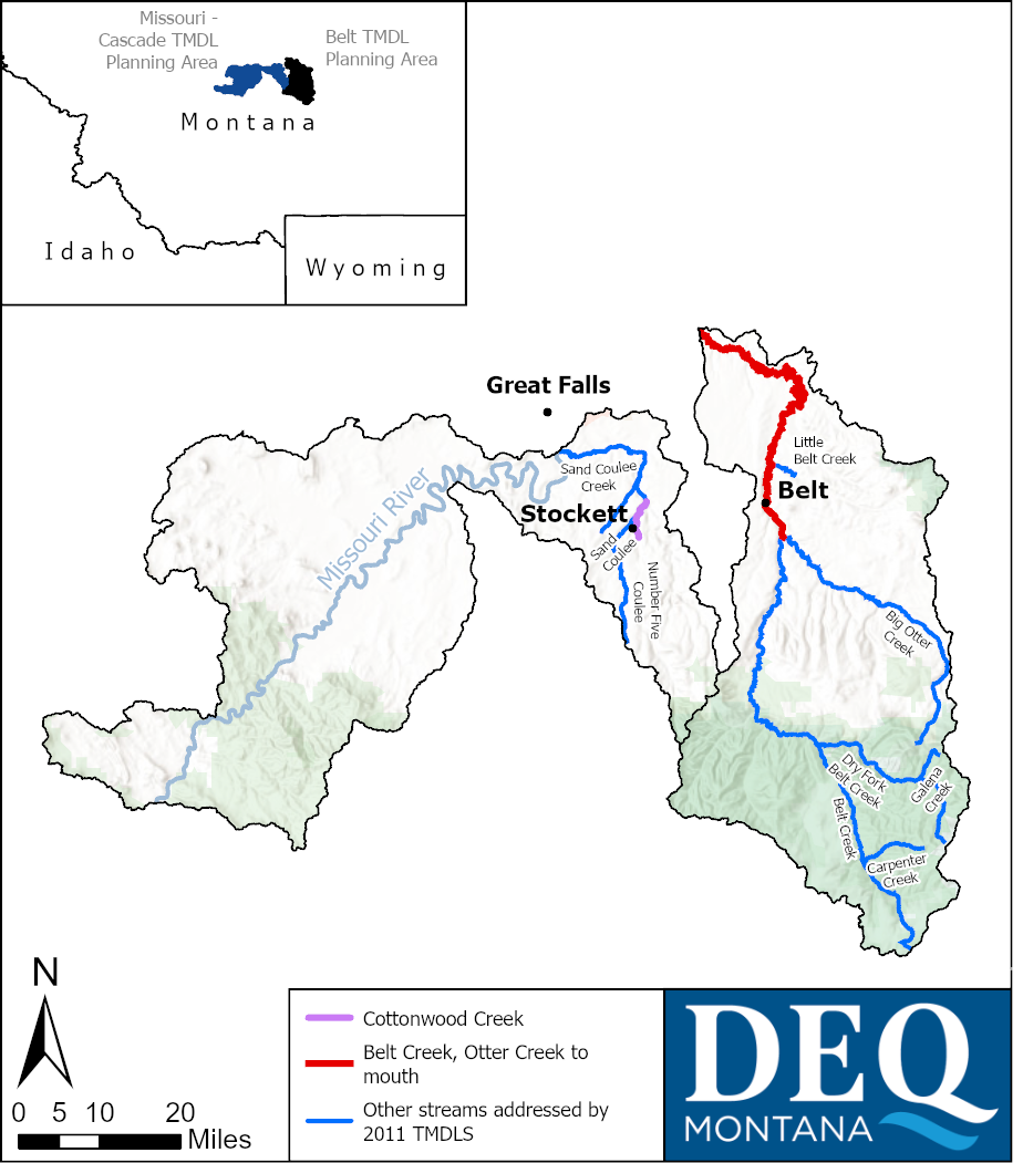
| Waterbody and Location Description | TMDL(s) Being Added | TMDL(s) Being Revised |
|---|---|---|
|
Lower Belt Creek Otter Creek to mouth (Missouri River) |
Aluminum | Arsenic, Cadmium, Iron, Lead, Zinc |
| Cottonwood Creek | Arsenic, Copper, Lead | none |
| Name | Role | Phone | |
|---|---|---|---|
| Joe Vanderwall | TMDL Revision Project Manager | Joseph.Vanderwall@mt.gov | (406) 444-4071 |
| Christina Staten | TMDL Section Supervisor | CStaten@mt.gov | (406) 444-2836 |
Red Rock Nutrient TMDLs
_0319.jpg)
This project focuses on nutrient total maximum daily load (TMDL) development in the Red Rock River watershed, which coincides with the Red Rock TMDL Planning Area. The "TMDL Development" accordion contains a table of the TMDLs being written for this project.
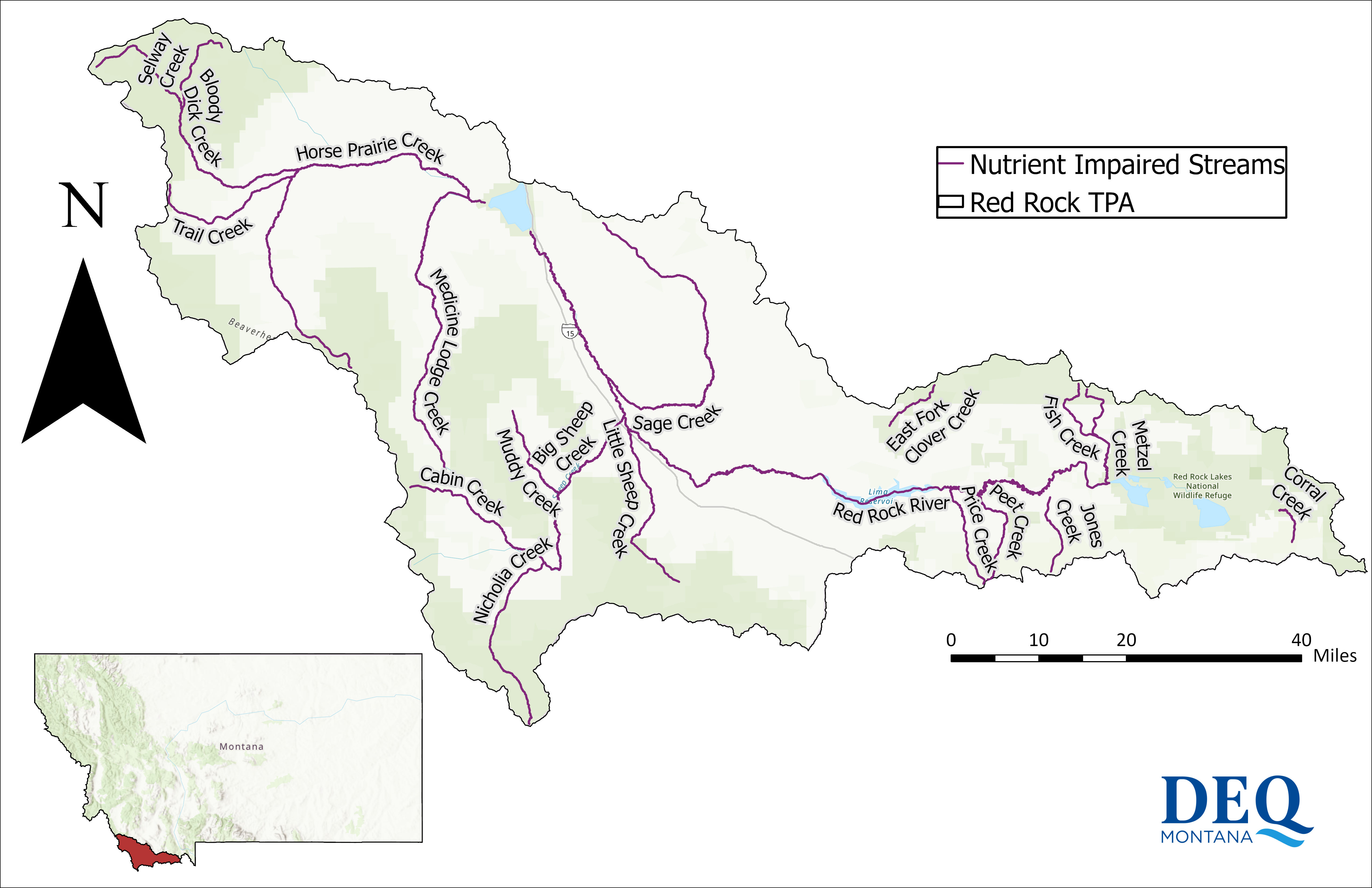
The majority of the Red Rock TMDL Planning Area lies within Beaverhead County, with a small portion extending into Madison County. The area includes the towns of Lakeview, Monida, Lima, Dell, Kidd, and Grant. The Red Rock TMDL Planning Area coincides with the fourth-code Hydrologic Unit Code (HUC 10020001) for the Red Rock River watershed and encompasses approximately 2,314 square miles, including the Horse Prairie Creek watershed to the west and the Red Rock River watershed to the east. Both drain into Clark Canyon Reservoir, which serves as the outlet for the watershed. The TMDL Planning Area is bounded by the Beaverhead and Tendoy Mountains to the southwest and the Centennial Mountains, Blacktail Mountains, Snowcrest Range, and Gravelly Range to the northeast.
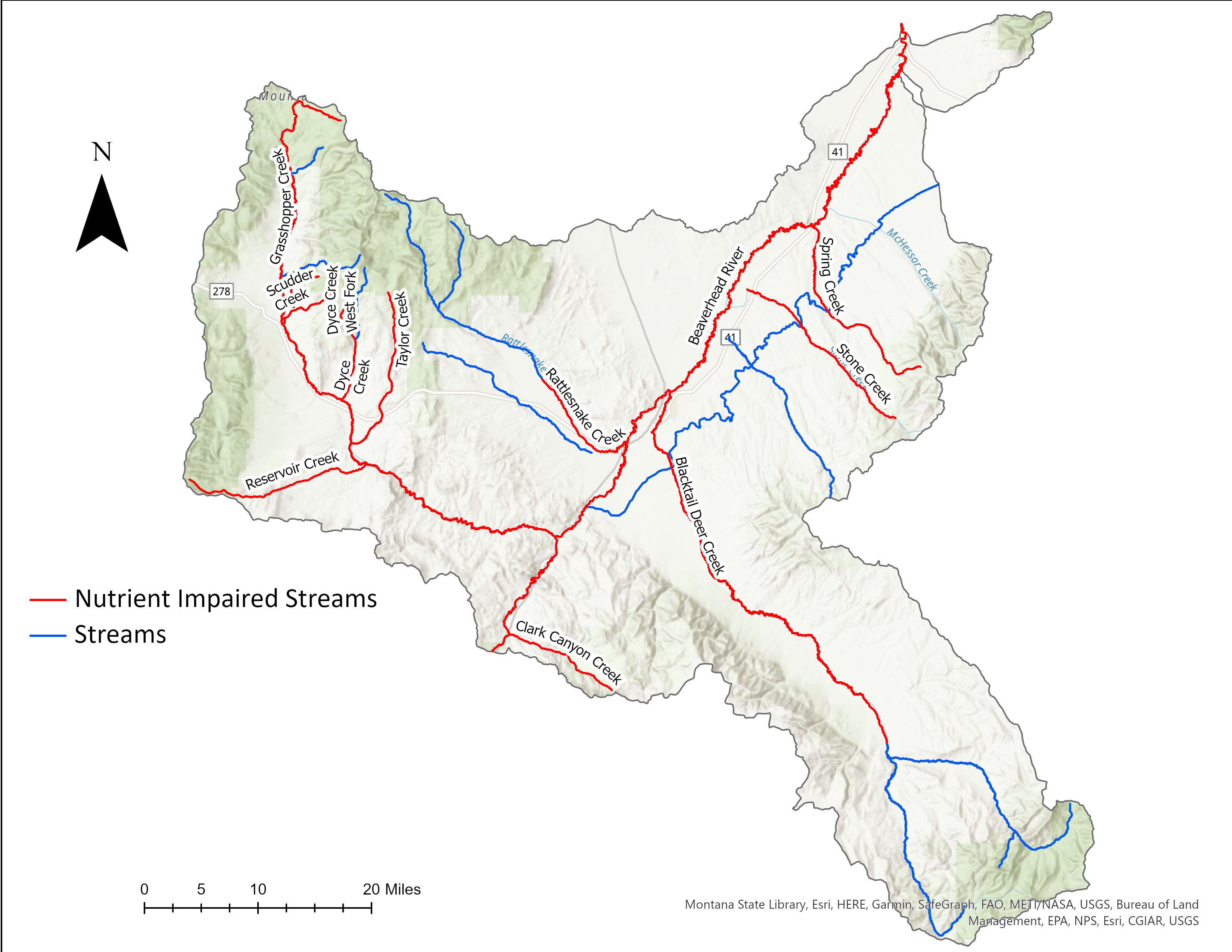
Monitoring for this project occurred primarily from 2015 to 2018 by Montana DEQ, with sampling assistance from the Centennial Valley Association. Based on this monitoring, 19 waterbodies were identified with nutrient impairments as shown on the map below.
Figure 2. Map of nutrient impaired streams within the Red Rock TPA.
_0256_adjusted.jpg)
The table below shows the nutrient total maximum daily loads (TMDLs) being developed for this project. After a waterbody is listed as impaired for any pollutant, a TMDL is calculated for that waterbody-pollutant combination. TMDLs represent the maximum amount of a pollutant that can enter a waterbody without exceeding the water quality standard. In addition, TMDL documents give specific recommendations for best management practices in order to meet the TMDL goals.
Sediment, metals, and E. coli TMDLs were completed for the Red Rock TMDL Planning Area in 2021. Completed TMDLs for the Red Rock TPA are contained in the 2021 "Red Rock Metals, Sediment, and E. coli TMDLs and Water Quality Improvement Plan" document, found on DEQ's TMDL webpage.
| Waterbody | Assessment Unit ID | Total Nitrogen TMDL | Total Phosphorus TMDL |
|---|---|---|---|
|
Big Sheep Creek Headwaters to mouth (Red Rock River) |
MT41A003_150 |
X |
X |
|
Bloody Dick Creek Headwaters to mouth (Horse Prairie Creek) |
MT41A003_100 |
-- |
X |
|
Cabin Creek Headwaters to mouth (Big Sheep Creek) |
MT41A003_030 |
X |
X |
|
Corral Creek Headwaters to mouth (Red Rock Creek) |
MT41A004_040 |
-- |
X |
|
East Fork Clover Creek Headwaters to mouth (Clover Creek) |
MT41A004_050 |
X |
X |
|
Fish Creek Headwaters to mouth (Metzel Creek) |
MT41A004_030 |
X |
X |
|
Horse Prairie Creek Headwaters to mouth (Clark Canyon Reservoir) |
MT41A003_090 |
X |
X |
|
Jones Creek Headwaters to mouth (Winslow Creek) |
MT41A004_130 |
X |
X |
|
Little Sheep Creek Headwaters to mouth (Red Rock River) |
MT41A003_160 |
X |
X |
|
Medicine Lodge Creek Headwaters to mouth (Horse Prairie Creek) |
MT41A003_010 |
X |
X |
|
Metzel Creek Headwaters to mouth (Red Rock River) |
MT41A004_020 |
X |
X |
|
Muddy Creek Confluence Sourdough and Wilson Creek to mouth (Big Sheep Creek) |
MT41A003_020 |
X |
X |
|
Nicholia Creek Headwaters to mouth (Big Sheep Creek) |
MT41A003_040 |
X |
X |
|
Peet Creek Headwaters to mouth (Red Rock River) |
MT41A004_090 |
X |
X |
|
Price Creek Headwaters to mouth (Red Rock River) |
MT41A004_010 |
X |
X |
|
Red Rock River Lower Red Rock Lake to Lima Dam |
MT41A001_020 |
X |
X |
|
Red Rock River Lima Dam to Clark Canyon Reservoir |
MT41A001_010 |
X |
X |
|
Sage Creek Headwaters to mouth (Red Rock River) |
MT41A003_140 |
X |
X |
|
Selway Creek Headwaters to mouth (Bloody Dick Creek) |
MT41A003_110 |
X |
X |
|
Trail Creek Headwaters to mouth (Horse Prairie Creek) |
MT41A003_080 |
X |
X |
| Name | Project Role | Phone | |
|---|---|---|---|
|
Hannah Adkins |
Nutrients TMDL Project Manager |
(406) 444-6871 | |
|
Christina Staten |
TMDL Section Supervisor |
(406) 444-2836 |
|
|
Torie Haraldson |
Nonpoint Source Program Contact |
(406) 556 - 4511 |
Smith River
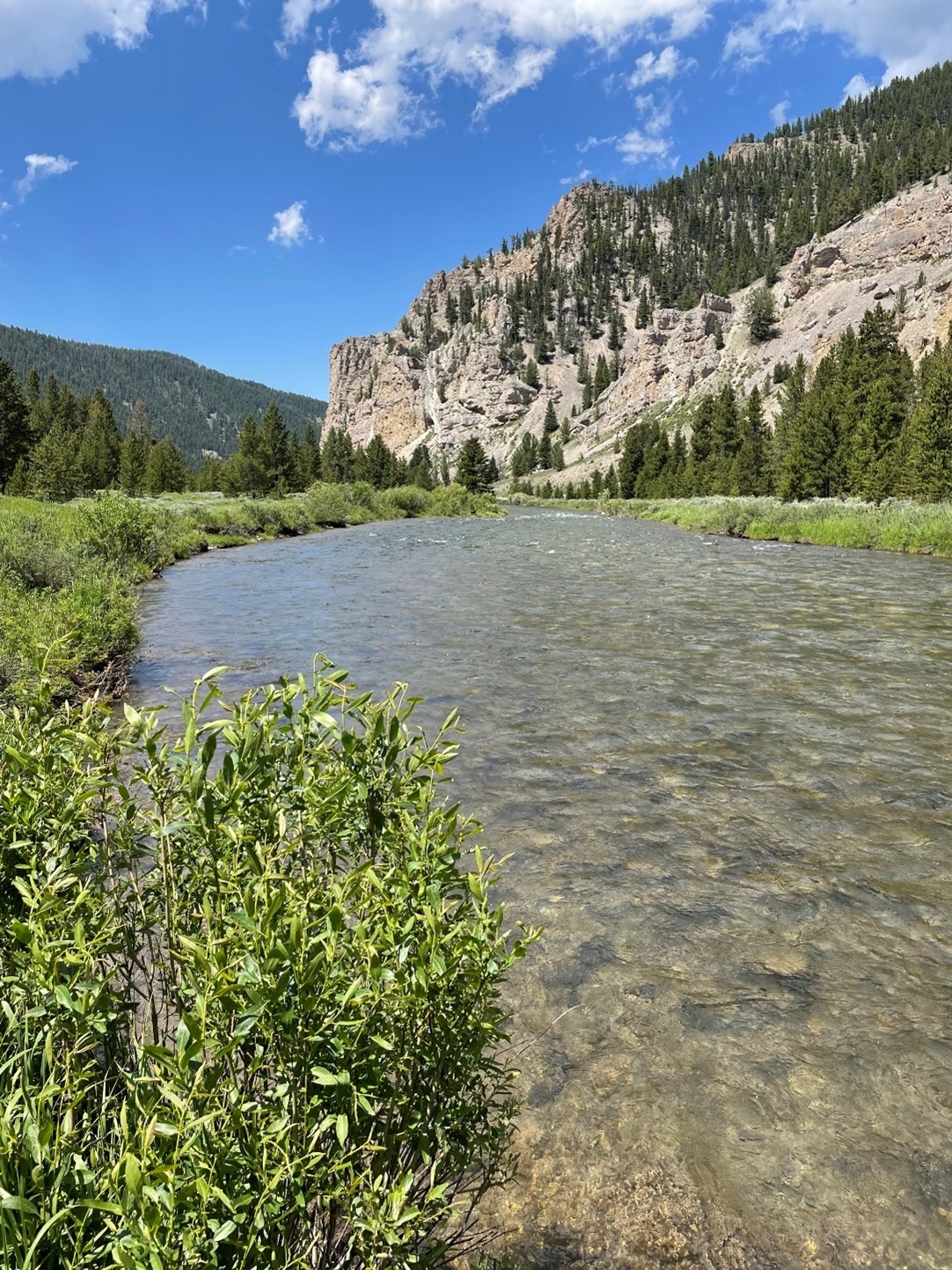
The Smith River begins near White Sulphur Springs at the confluence of its north and south forks and flows north approximately 125 miles to its confluence with the Missouri River. The Smith River watershed, shown on the map below with its major tributaries, is surrounded by the Little Belt Mountains to the east and the Big Belt Mountains to the west. The river is popular with recreators due to its trout fishery and canyon scenery, and floaters require a permit from Montana Fish, Wildlife, and Parks.

DEQ was involved in two major projects in the Smith River watershed that concluded in 2024. One investigated the causes of excess algae growth, and the other investigated baseline metals concentrations in the river and selected tributaries. Both final reports are available on this website. DEQ will assess the impairment status of the Smith River using data presented in these reports and all other available and credible data.
Algae Study
Beginning during the 2015 floating season, recreators reported attached algae growth in the Smith River beyond commonly observed levels. In response to these observations and additional complaints in subsequent years, the Montana Department of Environmental Quality (DEQ) began monitoring algae levels along the Smith River and investigating potential causes of the excess algae growth. DEQ completed the Smith River Algae Study in 2024. DEQ found that Cladophora glomerata (hereafter Cladophora) was the dominant algae species responsible for the excess growth. Cladophora is a native filamentous alga which forms long filamentous streamers which are attached to the stream bed and can, in excess, negatively impact recreators and aquatic life. DEQ found that the likely cause of the changing Cladophora growth is increasing air and water temperatures in the Smith River watershed. Warmer temperatures, aligned with other growth factors, can stimulate faster growth of Cladophora and other algae species especially in the month of June. The study found no increases in nutrient concentrations when compared to the 1970s, and found and no changes to river discharge timing, magnitude, or duration which could have favored excess Cladophora growth.
_0738.JPG)
The specific conclusions of the algae study include:
- Nutrients (nitrogen and phosphorus) are high in June due to normal runoff effects, and now there are also optimal river water temperatures for rapid algae growth occurring at the same time.
- In the Smith River valley, minimum daily air temperatures are trending warmer in spring and early summer, consistent with regional climate change.
- Smith River water temperatures are trending warmer in spring and early summer, driven by warmer air temperatures, and are moving into the ideal temperature range for rapid algae growth by June.
Metals Study
The Smith River watershed has also gained public attention due to the Black Butte Copper Project, an underground copper mine proposed by Tintina Montana, Inc. (Tintina) that would be located 15 miles north of White Sulphur Springs near Sheep Creek, a tributary of the Smith River. The proposed project area is in the south-central portion of the Sheep Creek drainage, approximately 19 miles upstream from the Smith River confluence. Direct impacts to the Smith River are not anticipated from the Black Butte Copper Project, but DEQ recognized the opportunity to simultaneously collect information on major ion and metal concentrations at the same time as the algae study detailed above. Between 2018-2019, DEQ collected water samples throughout the watershed for metals and ions. Water temperatures, flow rates, and other physical parameters were also monitored throughout this period.
Metals are a focus in the Smith River watershed due to diverse geologic conditions along with historical and ongoing land disturbance, primarily from agriculture and mining operations. DEQ completed the Smith River Metals Study in 2024, summarizing baseline ion and metal concentrations in the Smith River and selected tributaries. The report is available on this website and its major conclusions include:
- Data from the past decade show that metals concentrations are generally low throughout the Smith River, with the exception of aluminum and iron periodically not meeting the water quality standards for aquatic life at some locations.
- Some tributaries to the Smith River contribute to changes in metals and chemical characteristics at low concentrations, likely reflecting the natural weathering of geologic formations along with historical and ongoing human disturbance activities within the watershed.
- The metals study report summarizes background conditions prior to any construction or mine development at the Black Butte Copper Project near Sheep Creek, which today has not yet started any mining, water management, or water discharge activities.
After a waterbody is listed as impaired for any pollutant, a total maximum daily load (TMDL) is calculated for that waterbody-pollutant combination. TMDLs represent the maximum amount of a pollutant that can enter a waterbody without exceeding the water quality standard. In addition, TMDL documents give specific recommendations for best management practices in order to meet the TMDL value.
There is not an established timeline for TMDLs on the Smith River, but it is a DEQ priority due to the river’s importance. TMDLs will be completed for any pollutants causing impairment.
In early 2023, Montana Fish, Wildlife, and Parks (FWP) contracted Geum Environmental Consulting and Slough Creek Consulting to:
- Assess historical land use, existing water quality data, and information provided by local individuals and organizations to identify primary limitations to watershed health.
- Identify restoration strategies and priority locations to improve stream and floodplain conditions.
- Engage stakeholders and work towards facilitating restoration through local organizations.
_0589clean.jpg)
Key takeaways from the resulting report titled "Smith River Basin-wide Assessment Watershed Restoration Plan" include:
- The main degradational issues within the Smith River watershed are reduced streamflows, floodplain and riparian vegetation loss, increased erosion, increased water temperatures, and pollution from E. coli and nutrients.
- Agricultural land users and recreators play a critical role in implementing best management practices to restore watershed health.
- This report makes it possible to get grant funding for projects that restore watershed health.
| Meeting | Date | Location | Meeting Materials |
|---|---|---|---|
|
Algae Water Quality Planning Project 2017 |
10/11/2017 | Helena |
|
|
Excess Algae Study Open House Public Meeting 2018 |
3/1/2018 | White Sulphur Springs |
|
|
Smith River Excess Algae Study Public Meeting 2019 |
3/12/2019 | White Sulphur Springs |
|
|
Smith River Excess Algae Study Public Meeting 2020 |
3/18/2020 | White Sulphur Springs |
|
|
Smith River Basin-wide Assessment Stakeholder Meeting |
5/24/2023 | White Sulphur Springs |
|
|
Smith River Basin-wide Assessment Public Meeting |
6/17/2024 | White Sulphur Springs |
|
|
Smith River Projects Open House |
1/16/2025 from 5-7 pm |
Meagher County Community Center 101 1st Ave, White Sulphur Springs |
|
| Document | Description | Version and Date |
|---|---|---|
| Study investigating the drivers of excess algae growth in the Smith River. | Final (October 2024) | |
| Study investigating metal concentrations in the Smith River and selected tributaries. | Final (December 2024) | |
| Identifies areas and best management practices for restoration in the Smith River watershed. | Final (December 2024) |
| Name | Role | Phone | |
|---|---|---|---|
| Gabrielle Metzner | Water quality assessor | gabrielle.metzner@mt.gov | (406) 444-2709 |
| Garrett Smith | Metals Study | gsmith5@mt.gov | (406) 444-1967 |
| Darrin Kron | Monitoring and Assessment Section Supervisor | dkron@mt.gov | (406) 444-4765 |
| Christina Staten | TMDL Section Supervisor | cstaten@mt.gov | (406) 444-2836 |
| Adam Geik | Montana Fish, Wildlife, and Parks: Watershed Restoration Plan | ageik@mt.gov | (406) 454-5855 |
Nonpoint Source & Wetlands Focus Watersheds
DEQ's Nonpoint Source and Wetlands Program works with stakeholders across the state to protect and restore water quality from the harmful effects of nonpoint source pollution. In 2019, the Nonpoint Source Program began identifying Focus Watersheds to support with approximately half of the available 319 funds and significant technical resources for up to three years.
With the goal of influencing significant and measurable progress toward reducing nonpoint source pollution, DEQ considers many factors when selecting a Focus Watershed:
- One or more DEQ-accepted Watershed Restoration Plans are in place.
- Resources and momentum exist through active watershed groups, agencies, or other entities promoting water quality and/or habitat protection.
- Local citizens, stakeholders, and visitors are interested in, support, and value natural resources provided by water quality.
- The extent to which DEQ resources can provide increased momentum for water quality improvement actions on the ground.
- DEQ’s ability to track changes in water quality and/or key water quality indicators through time.
- Supports other agency or other internal DEQ program priorities.
- The extent of nonpoint source pollution issues and related impairment conditions that can be addressed via traditional BMPs.
- Opportunities to reduce municipal wastewater or other point source water treatment costs by reducing upstream nonpoint sources of pollution.
Once a Focus Watershed is selected, DEQ employs four main strategies to build and maintain momentum to achieve water quality improvement:
Fostering engagement in water quality issues by:
- Increasing voluntary restoration and monitoring activities
- Engaging new landowners
- Improving understanding of barriers to participation in nonpoint source pollution prevention/reduction
Building the capacity of local groups & leaders by:
- Providing fine-scale source assessment for project identification
- Supporting WRP updates
- Funding for capacity and implementation of nonpoint source education and water quality improvement projects
Tracking water quality indicators by:
- Evaluating riparian health
- Completing TMDL Implementation Evaluations
Identifying success stories by:
- Completing Projects Effectiveness Reviews
- Publishing nationally-recognized success stories when water quality standards are achieved
Lower Gallatin Focus Watershed (2023-2025)
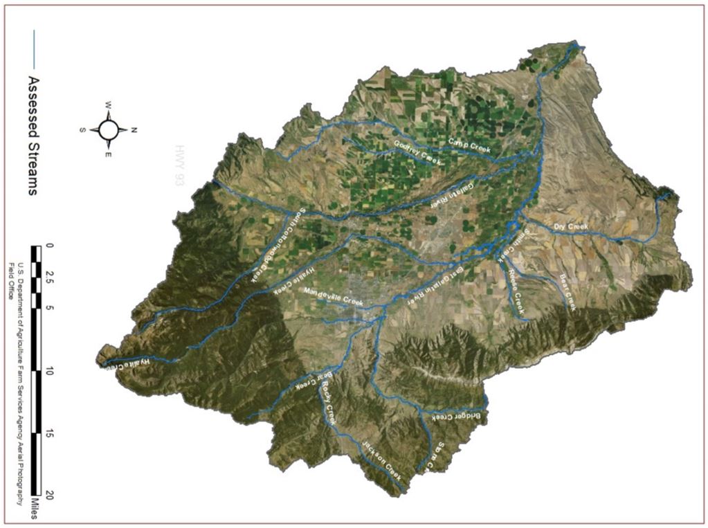
The Lower Gallatin Watershed is located in the south-central portion of the state, and includes parts of Gallatin, Park, and Madison Counties. The Focus Watershed project area includes the towns of Bozeman, Belgrade and Manhattan, and the streams draining the northern flanks of the Gallatin Range and much of the Bridger Range. It covers 997 square miles (638,381 acres) between these headwaters and the confluence of the Gallatin, Madison and Jefferson rivers near Three Forks. DEQ has assessed many streams of the Lower Gallatin watershed and identified numerous water quality impairments.
Factors in selection of the Lower Gallatin Watershed:
– DEQ and local stakeholder groups had created the planning documents needed to quantify water quality impairments and sources and developed strategies for how to best address these impairments.
- Lower Gallatin Planning Area TMDLs & Framework Water Quality Improvement Plan (DEQ, 2013)
- Lower Gallatin Watershed Restoration Plan (Greater Gallatin Watershed Council, 2014)
– The importance of timely support to implement high-priority water quality improvement projects in the context of a fast-growing population.
– The capacity potential of the many local agency, nonprofit, and academic groups working to monitor and improve water quality in the watershed
– The potential to improve water quality and reduce the community’s point source treatment costs by implementing nonpoint source BMPs.
The voluntary implementation of projects and activities to address nonpoint sources of pollution rely on the education and empowerment of communities to take action. In 2020, DEQ partnered with local stakeholders to conduct a Community Readiness Assessment (CRA) to identify the current stage of readiness in the Lower Gallatin Watershed to address nonpoint source challenges and the key actions to move toward ownership and action on these challenges.
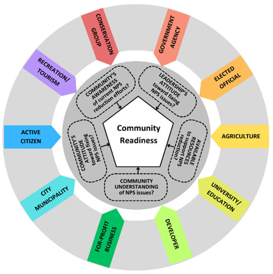
The Lower Gallatin CRA used interviews with leaders from ten community sectors (outer ring) to evaluate five dimensions of community readiness to address nonpoint source issues (inner ring).
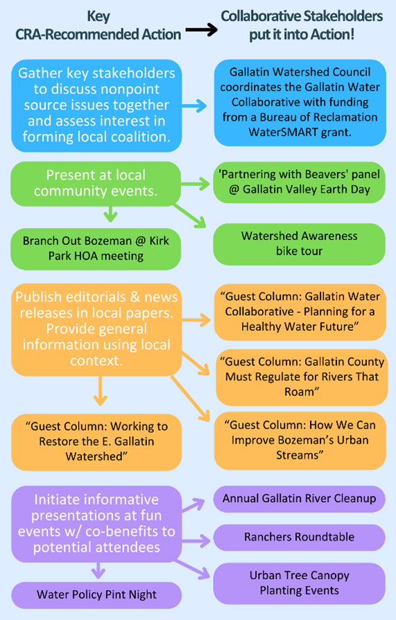
With representatives from the sectors identified in the CRA, the Gallatin Water Collaborative convened with the broader mission of “unifying local efforts to protect, restore and enhance water resources”. Many Collaborative stakeholder groups have been implementing the key actions recommended in the CRA, advancing readiness to address nonpoint source pollution in the watershed.
Lower Gallatin stakeholders have taken advantage of their focus watershed status by increasing the pace of on-the-ground restoration work. In the ten years between approval of the Lower Gallatin Watershed Restoration Plan and the focus watershed designation, only $314,302 in 319 funds had been directed to projects in the watershed. In just three years as the focus watershed, local stakeholder groups have been awarded nearly $1.1M in project funds.
Please visit our 319 Restorations Projects map for more information about restoration projects in the Lower Gallatin.
Tracking water quality is an important component of documenting the success of the focus watershed designation. Several projects are anticipated to assist with this work.
Lower Gallatin Riparian Evaluation:
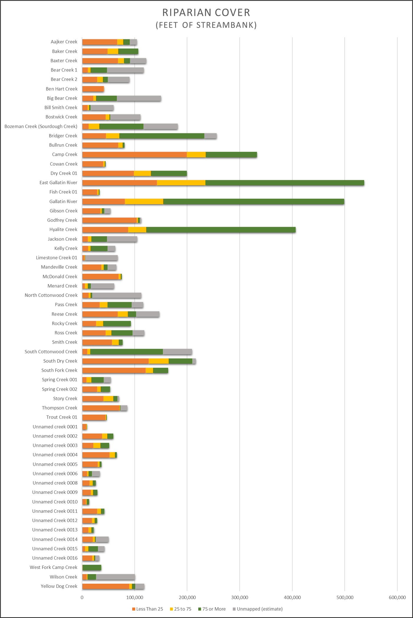
Riparian evaluation can generate fine-scale riparian cover and potential pollution source data to support locally-led efforts to improve water quality and protect watershed health. Prior to the availability of increased funding, DEQ evaluated 59 streams in the Lower Gallatin watershed as tool for:
- Prioritizing waterbodies in need of on-the-ground water quality improvement projects
- Prioritizing healthy waterbodies and riparian areas for protection
- Planning outreach and education efforts to reach audiences with the greatest potential to protect or improve water quality
Wetland Restoration Effectiveness Monitoring at Mandeville Creek:
DEQ is monitoring several restored wetland sites throughout the state to define a methodology for quantifying site-specific nutrient and sediment load reductions associated with wetland restoration. One such site is at Trout Unlimited’s 319 project site on Mandeville Creek. In addition to helping DEQ quantify how restored wetland projects uptake nutrients and attenuate sediment, this project is poised to help the City of Bozeman evaluate the potential for similar stream and wetland restoration projects within the watershed to become a component of their wastewater treatment permit.
The Gallatin Local Water Quality District’s Surface Water Monitoring Network:
The Gallatin Local Water Quality District (GLWQD) is a non-regulatory department of Gallatin County government with a mission to protect, preserve and improve water quality. GLWQD collects long-term surface water quality and quantity data at sixteen monitoring stations on twelve streams within the focus watershed boundary. Regular data collection from these monitoring stations began in spring of 2018 with a goal of trends analysis of many parameters commonly associated with nonpoint source pollution. Visit the GLWQD website for more information about their surface water monitoring efforts.
The Gallatin Water Science Symposium
In February 2025, the first Gallatin Water Science Symposium was convened on the campus of Montana State University. The event was an opportunity for water resource managers and researchers to connect with stakeholders to share their work surrounding water in the Gallatin. Symposium attendees identified the meeting as a critical step toward more collaborative and informed water stewardship in the Gallatin Watershed.
Bridging Science & Action: Highlights from the Inaugural Gallatin Water Science Symposium
Gallatin Water Collaborative Recognized for Outstanding Watershed Stewardship
In 2025, the Gallatin Water Collaborative was honored by the Montana Watershed Coordination Council with the Montana Watershed Stewardship Award, recognizing the group for its comprehensive and collaborative approach to protecting and restoring water resources in the rapidly growing Gallatin Valley. Factors considered in nominees for this award include inclusive and effective local collaboration, measurable results, community outreach and education, and a holistic approach to wetland and watershed health.
- Video highlighting the work of the Gallatin Watershed Council
- Story by the Montana Watershed Coordination Council on the Gallatin Watershed
TMDL Implementation Evaluations (TIEs)
The Lower Gallatin TMDL document presented a plan to reduce pollution from different sources in order to achieve water quality standards. The focus watershed designation provides local stakeholders with increased financial capacity to implement on-the-ground restoration projects to reduce the nonpoint sources of pollutants presented in the TMDL. Once these projects have been implemented, TMDL Implementation Evaluations (TIEs) compile the planning, restoration, and monitoring that has occurred, summarize findings of the original TMDL Document and provide recommendations for improving water quality further. TIEs also make monitoring recommendations to reassess streams and determine if water quality standards are now being attained.
No TIEs have been completed in the Lower Gallatin to date, but DEQ will be working with partners as we move forward to identify areas for TIE development.
Completed Projects
Information on select past projects will be found here. When the Water Quality Planning Bureau (Bureau) of DEQ is actively working in a watershed with completed water quality planning work, past project history may be provided here. This section is not intended to be an all-inclusive list of completed water quality planning work performed by the Bureau.
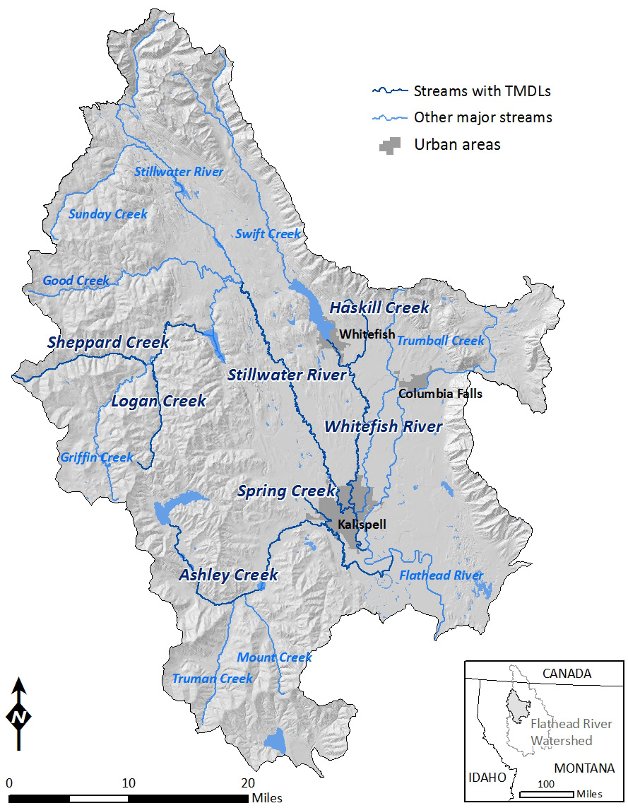
The Flathead-Stillwater Planning Area Nutrient, Sediment, and Temperature TMDLs and Water Quality Improvement Plan was approved by EPA on December 17th, 2014. The document includes completed nutrient, sediment, and temperature TMDLs for the tributaries in Table 1 below. The final document can be found on DEQ's TMDL webpage. Copies of the final TMDL document are also available at the Big Fork, Columbia Falls, Kalispell, Missoula, Polson, and Whitefish public libraries.
The Flathead-Stillwater TMDL Planning Area encompasses around 1430 square miles in northwestern Montana (see map below). The planning area is bounded in the north by the Whitefish mountains, in the east by the Swan mountains, in the west by the Upper Kootenai and Fisher River drainages, and in the south by Flathead Lake. Major surface waters within the Flathead-Stillwater TMDL Planning Area include Ashley Creek, the Stillwater River, the Whitefish River, and the Flathead River between the confluence of its three forks and Flathead Lake.
TMDLs included in the EPA-approved 2014 "Flathead-Stillwater Planning Area Nutrient, Sediment, and Temperature TMDLs and Water Quality Improvement Plan" document are shown in the table below.
| Waterbody and Location Description | TMDL(s) Written in 2014 |
|---|---|
|
Ashley Creek Ashley Lake to Smith Lake |
Total Nitrogen, Sediment, Temperature |
|
Ashley Creek Smith Lake to Kalispell Airport Road |
Total Nitrogen, Total Phosphorus, Sediment, Temperature |
|
Ashley Creek Kalispell Airport Road to mouth (Flathead River) |
Total Nitrogen, Total Phosphorus, Sediment, Temperature |
|
Logan Creek headwaters to Tally Lake |
Sediment |
|
Haskill Creek Haskill Basin Pond to mouth (Whitefish River) |
Sediment |
|
Sheppard Creek headwaters to mouth (Whitefish River) |
Sediment |
|
Spring Creek headwaters to mouth (Ashley Creek) |
Total Nitrogen, Total Phosphorus |
|
Stillwater River Logan Creek to mouth (Flathead River) |
Sediment |
|
Whitefish River Whitefish Lake to mouth (Stillwater River) |
Temperature |