
Smoke Forecast for Tuesday, September 9, 2025 9:30 AM
Current Conditions
A slow-moving area of low pressure will spread clouds and precipitation across the region the next 48-hours.
The Ulm Creek fire, burning just west of Trout Creek, Montana, is much less active than the prior week. It has grown to 2,529 acres and is 10% contained. The Knowles fire burning near Paradise, Montana, has burned 3,816 acres. The blaze is now 60% contained. The Devil Mountain and Windy Rock fires, burning 15 miles northeast of Drummond, were active again on Monday. The Devil Mountain fire has burned 1,932 acres and the Windy Rock has grown to 5,508 acres and is 14% contained. The Ransome fire, burning just north of Libby, remained active on Monday. It has grown to 701 acres and is 29% contained. The Timber Butte fire, burning just west of Dell, Montana, was less active on Monday. It has burned 2,245 acres and is 56% contained. There are several active wildfires burning in central and northern Idaho. The biggest of concern for Montana’s air quality are the East, Mire, Rhoda Creek, Big Bear and Rush wildfires.
At 9:00 AM Tuesday, Columbia Falls, Libby, Frenchtown, Great Falls, Lewistown, Billings, Broadus, Miles City, Glasgow, and Sidney's air quality is Moderate.
By Wednesday afternoon, the High-Resolution Rapid Refresh (HRRR) smoke model shows surface smoke covering much of the state from regional wildfires.
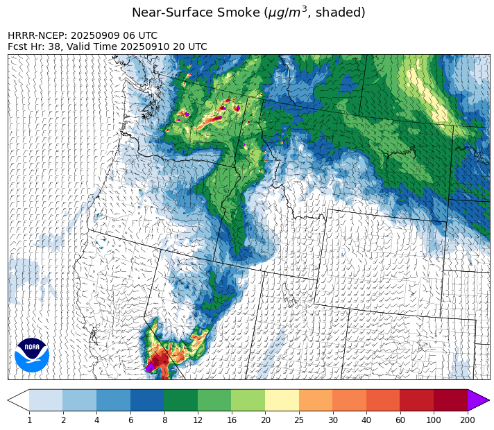
Source: HRRR-smoke
Forecast
Fire behavior across Idaho and Montana remains active despite clouds, recent precipitation, and cooler temperatures. A large, slow-moving area of low pressure will crawl east across the region the 48-hours, spreading clouds and scattered showers to the area. The massive Garnet fire, burning in central California, will spread smoke into the Treasure State. However, much of the smoke from this fire will be elevated, with limited impacts to surface monitors. Expect hazy skies across the state from regional wildfires.
On Wednesday, the center of the low approaches Montana. Monsoonal moisture and daytime heating will interact with the low-pressure system, providing increasing chances for beneficial precipitation. A southwesterly flow aloft will continue to transport smoke from regional wildfires into Montana.
By Thursday and Friday, the center of the low moves over the state. This will provide clouds and cooler temperatures for the area, helping to moderate fire behavior and limit smoke production. This is also the window of time with the best chances for rain and thunderstorms. The precipitation from this event will slow wildfire season and reduce smoke production. Unfortunately, it’s unlikely to put the nail in the coffin on wildfires this season. Stay tuned!
Conditions can change quickly as weather could stimulate active fires and the likelihood of new starts increases. Please keep track of concentrations at todaysair.mtdeq.us or the Fire and Smoke Map.
Tuesday morning’s satellite image reveals smoke covering much of the state from regional wildfires.
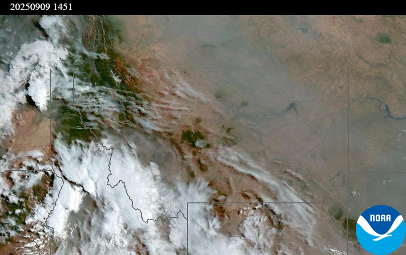
Source: NOAA
| Incident Name | State | Location | Acres | Containment |
|---|---|---|---|---|
| Rock Fire | Idaho | 5 miles southwest of Donnelly, ID | 2796 | 92% |
| Island Creek | Idaho | 14 Miles N of Elk City, ID | 14802 | 5% |
| East | Idaho | 8 miles northwest of Powell Idaho | 2114 | 0% |
| Mire | Idaho | Approximately 25 miles west of Powell Idaho and 35 miles northeast of Lowell Idaho | 1321 | 0% |
| Green Rattle Complex | Idaho | NA | 201 | NA |
| Lightning Creek Fire | Idaho | 9 miles north of Clark Fork, ID | 2525 | 25% |
| Green Mtn Fire | Idaho | 8 miles West/Southwest of Clark Fork, ID | 8 | 0% |
| Rattle Mountain Fire | Idaho | 13 miles North/Northeast of Clark Fork, ID | 80 | 0% |
| White Pine | Idaho | 7 Miles NE of Harvard, ID near White Pine Campground and Trailhead | 406 | 10% |
| Ulm Creek Fire | Idaho | 16 miles north of Prichard, ID and 10 miles south of Heron, MT. | 2529 | 10% |
| Twin | Idaho | 29 air miles northeast of Headquarters, ID in Twin Cabin Creek drainage, a tributary to Quartz Creek on the North Fork Ranger District. | 761 | 0% |
| Big Bear | Idaho | 59 Miles NE of McCall, Idaho - Frank Church-River of No Return Wilderness | 16249 | 70% |
| Rush | Idaho | 57 Miles NW of McCall, Idaho - Frank Church-River of No Return Wilderness | 7908 | 90% |
| Shingle | Idaho | NA | 100 | 55% |
| Elkhorn Fire | Idaho | 45 Miles E of Challis, ID | 1779 | 0% |
| West Fork Fire | Montana | 23 Miles NW of West Yellowstone, MT, Custer Gallatin National Forest | 963 | 83% |
| Ransome Fire | Montana | 11 Miles northwest of Libby, MT | 701 | 29% |
| Windy Rock Fire | Montana | 15 Miles NE of Drummond, MT | 5508 | 14% |
| Cloudrest | Montana | 15 Miles northwest of Virginia City, MT | 3148 | 54% |
| Timber Butte | Montana | 6 miles west of Dell, MT | 2245 | 56% |
| Isabella & Lost Girl Fires | Montana | NA | 457 | 0% |
| Knowles Fire | Montana | 11 Miles E of Plains, MT | 3816 | 60% |
| Sandbar 2 Fire | Montana | 15 miles east of Lincoln, Montana; north of Montana State Highway 279 and Flesher Pass | 243 | 75% |
| McAllister Fire | Montana | Madison County, 3 miles south of Norris, 3 miles north of Ennis Lake | 3560 | 95% |
| Gill Gulch Fire | Montana | 7 Miles south of Lincoln, MT | 34 | 75% |
| Bridge Fire | Oregon | Malheur National Forest, Blue Mountain Ranger District | 350 | 29% |
| Marks Creek | Oregon | 18 miles east of Prineville, Oregon | 1718 | 27% |
| Emigrant Fire | Oregon | 24 miles southeast of Oakridge, Oregon | 32294 | 1% |
| Black Rock Fire | Oregon | 13 miles west of Fossil, OR | 40684 | 10% |
| Kelsey Peak Fire | Oregon | 15 miles west of Glendale, Oregon | 919 | 0% |
| Moon Complex | Oregon | 11 Miles NE of Agness, OR | 3238 | 0% |
| Flat Fire | Oregon | 4 Miles Northeast of Sisters, OR | 23346 | 81% |
| Tacoma Creek Fire | Washington | 15 miles NW of Cusick, WA | 3377 | 0% |
| Katy Creek | Washington | 6 Miles NW of Kettle Falls, WA | 3389 | 0% |
| Crown Creek Fire | Washington | 1 Mile SE of Marble, WA | 14211 | 10% |
| Lower Sugarloaf Fire | Washington | 17 miles west of Entiat, WA | 12685 | 0% |
| Rattlesnake | Washington | 2 miles West of Seven Bays, WA | 17713 | 7% |
| Lynx Mountain | Washington | 7 Miles NW of Inchelium, WA | 3541 | 0% |
| Wildcat Fire | Washington | 30 miles West of Naches, WA | 7736 | 0% |
| Bear Gulch Fire | Washington | 10 Miles Northwest of Hoodsport, WA | 10275 | 9% |
| Perry Fire | Washington | 16 miles NE of Newhalem, WA, west of Ross Lake | 1557 | 0% |
| Martin | Washington | 45 Miles NW of Chelan, WA | 174 | 5% |
| Labor Mountain Fire | Washington | 10 miles North of Cle Elum, WA | 1984 | 0% |
| Sugar | Washington | 5 Miles NE of Conconully, WA | 63 | 0% |
| Snow Peak | Washington | 19 miles W of Kettle Falls | 700 | 0% |
| Pomas Fire | Washington | Approximately 36 miles northwest of Entiat, WA | 3533 | 0% |
Tags: Smoke Forecast 2025