
Smoke Forecast for Monday, September 8, 2025 9:45 AM
Current Conditions
Even though Monday will likely be the warmest day of the week, surface smoke and haze have decreased considerably compared to 24-hours ago.
The Ulm Creek fire, burning just west of Trout Creek, Montana, has gained a lot of acreage this week. It has grown to 2,529 acres and is 10% contained. The Knowles fire burning near Paradise, Montana, has burned 3,816 acres. The blaze is now 60% contained. Firefighters have made considerable progress on the Bivens Creek and Cloudrest, burning in the Tobacco Root Mountains. The Bivens Creek fire is now 94% contained, and the Cloudrest fire is 54% contained. The Devil Mountain and Windy Rock fires, burning 15 miles northeast of Drummond, were active again on Friday. The Devil Mountain fire has burned 1,932 acres and the Windy Rock has grown to 5,508 acres and is 14% contained. The Ransome fire, burning just north of Libby, was less active on Sunday. It has grown to 693 acres and is 23% contained. The Timber Butte fire, burning just west of Dell, Montana, was active on Sunday. It as burned 2,245 acres and is 56% contained. There are several active wildfires burning in central and northern Idaho. The biggest of concern for Montana’s air quality are the East, Mire, Rhoda Creek, and Ulm Creek wildfires.
At 9:00 AM Monday, Columbia Falls, Libby, Lewistown, Cut Bank, Great Falls, Malta, Miles City, Billings, Glasgow, Sleeping Giant, and Broadus’ air quality is Moderate.
By Tuesday afternoon, the High-Resolution Rapid Refresh (HRRR) smoke model shows surface smoke covering much of the state from regional wildfires.
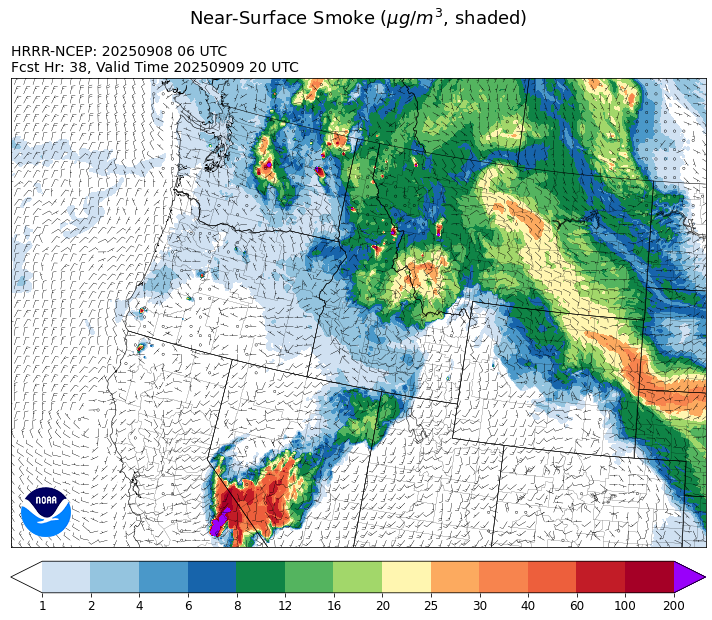
Source: HRRR-smoke
Forecast
Smoke and haze across the Treasure State isn’t nearly as widespread as it was 24-hours ago. A slow-moving area of low pressure will push onshore along the Pacific Coast on Monday. A southwesterly flow will continue to pump anomalously moist air into the Northern Rockies, setting the stage for scattered showers and thunderstorms. These storms will bring heavy rain, lightning, gusty winds, and even some small hail. Several new fire starts were sparked on Sunday thanks to thunderstorms over the western third of Montana and across central Idaho.
Moisture and instability increase across the state on Tuesday. This will lead to more widespread precipitation for the area. Temperatures should gradually cool closer to seasonal averages. Higher humidity, cooler air, and precipitation will help to moderate fire behavior and reduce surface smoke from regional wildfires as the week goes on.
A southerly flow will persist throughout the week, pumping monsoonal moisture into the area. The Pacific low will gradually plod across the state, interacting with this moisture, providing daily chances for beneficial rain. Many long-range models show a cool and showery pattern continuing into the upcoming weekend. Stay tuned!
Conditions can change quickly as weather could stimulate active fires and the likelihood of new starts increases. Please keep track of concentrations at todaysair.mtdeq.us or the Fire and Smoke Map.
Monday morning’s satellite image reveals smoke covering the northern and eastern portions of the state.
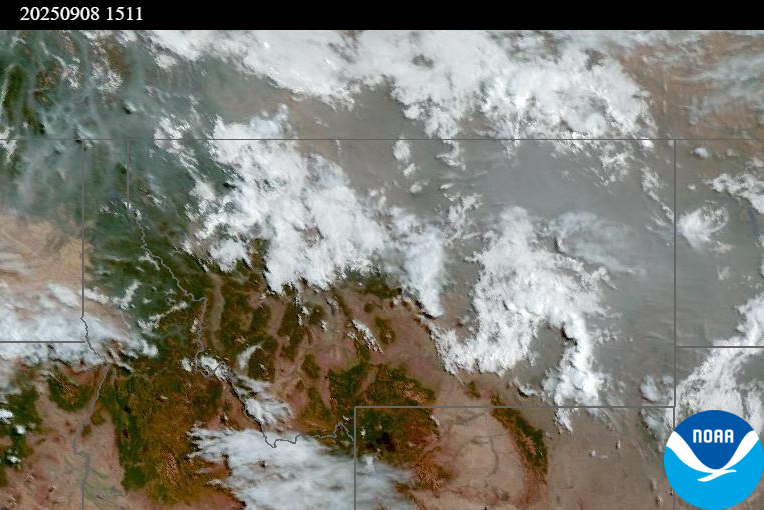
Source: NOAA
| Incident Name | State | Location | Acres | Containment |
|---|---|---|---|---|
| Ulm Creek Fire | Idaho | 16 miles north of Prichard, ID and 10 miles south of Heron, MT. | 2529 | 10% |
| Rock Fire | Idaho | 5 miles southwest of Donnelly, ID | 2796 | 87% |
| White Pine | Idaho | 7 Miles NE of Harvard, ID near White Pine Campground and Trailhead | 253 | 10% |
| Green Mtn Fire | Idaho | 8 miles West/Southwest of Clark Fork, ID | 8 | 0% |
| Rattle Mountain Fire | Idaho | 13 miles North/Northeast of Clark Fork, ID | 80 | 0% |
| Island Creek | Idaho | 14 Miles N of Elk City, ID | 14737 | 5% |
| East | Idaho | 8 miles northwest of Powell Idaho | 1892 | 0% |
| Mire | Idaho | Approximately 25 miles west of Powell Idaho and 35 miles northeast of Lowell Idaho | 1216 | 0% |
| Big Bear | Idaho | 59 Miles NE of McCall, Idaho - Frank Church-River of No Return Wilderness | 16249 | 70% |
| Rush | Idaho | 57 Miles NW of McCall, Idaho - Frank Church-River of No Return Wilderness | 7908 | 90% |
| Lightning Creek Fire | Idaho | 9 miles north of Clark Fork, ID | 2525 | 25% |
| Elkhorn Fire | Idaho | 45 Miles E of Challis, ID | 1779 | 0% |
| Windy Rock Fire | Montana | 15 Miles NE of Drummond, MT | 5508 | 14% |
| Bivens Creek | Montana | 15 Miles North of Virginia City, MT | 2126 | 94% |
| Cloudrest | Montana | 15 Miles northwest of Virginia City, MT | 3148 | 54% |
| Timber Butte | Montana | 6 miles west of Dell, MT | 2245 | 56% |
| Knowles Fire | Montana | 11 Miles E of Plains, MT | 3816 | 60% |
| West Fork Fire | Montana | 23 Miles NW of West Yellowstone, MT, Custer Gallatin National Forest | 963 | 83% |
| Ransome Fire | Montana | 11 Miles northwest of Libby, MT | 693 | 23% |
| Corral Creek Fire | Montana | 4.5 miles south of Huson, MT | 356 | 92% |
| Sandbar 2 Fire | Montana | 15 miles east of Lincoln, Montana; north of Montana State Highway 279 and Flesher Pass | 243 | 75% |
| McAllister Fire | Montana | Madison County, 3 miles south of Norris, 3 miles north of Ennis Lake | 3560 | 95% |
| Gill Gulch Fire | Montana | 7 Miles south of Lincoln, MT | 34 | 75% |
| Black Rock Fire | Oregon | 13 miles west of Fossil, OR | 32453 | 10% |
| Bridge Fire | Oregon | Malheur National Forest, Blue Mountain Ranger District | 350 | 0% |
| Marks Creek | Oregon | 18 miles east of Prineville, Oregon | 1925 | 0% |
| Emigrant Fire | Oregon | 24 miles southeast of Oakridge, Oregon | 31897 | 1% |
| Moon Complex | Oregon | 11.5 Miles NE of Agness, OR | 2229 | 0% |
| Kelsey Peak Fire | Oregon | 15 miles west of Glendale, Oregon | 507 | 0% |
| Flat Fire | Oregon | 4 Miles Northeast of Sisters, OR | 23346 | 81% |
| Katy Creek | Washington | 6 Miles NW of Kettle Falls, WA | 3162 | 0% |
| Crown Creek Fire | Washington | 1 Mile SE of Marble, WA | 14139 | 10% |
| Lynx Mountain | Washington | 7 Miles NW of Inchelium, WA | 2961 | 0% |
| Rattlesnake | Washington | 2 miles West of Seven Bays, WA | 13480 | 0% |
| Wildcat Fire | Washington | 30 miles West of Naches, WA | 7595 | 0% |
| Snow Peak | Washington | 19 miles W of Kettle Falls | 700 | 0% |
| Labor Mountain Fire | Washington | 10 miles North of Cle Elum, WA | 1984 | 0% |
| Lower Sugarloaf Fire | Washington | 17 miles west of Entiat, WA | 10000 | 0% |
| Perry Fire | Washington | 16 miles NE of Newhalem, WA, west of Ross Lake | 1557 | 0% |
| Tacoma Creek Fire | Washington | 15 miles NW of Cusick, WA | 2717 | 0% |
| Bear Gulch Fire | Washington | 10 Miles Northwest of Hoodsport, WA | 10275 | 9% |
| Martin | Washington | 45 Miles NW of Chelan, WA | 174 | 5% |
| Pomas Fire 2025 | Washington | Approximately 36 miles northwest of Entiat, WA | 3533 | 0% |
| Grande Fire | Washington | 12 miles north of Colville | 22 | 65% |
Tags: Smoke Forecast 2025