
Smoke Forecast for Saturday, September 6, 2025 9:30 AM
Current Conditions
Montana DEQ is issuing an Air Quality Alert for Beaverhead, Deer Lodge, Granite, Ravalli, Mineral, Sanders, and Lincoln Counties because of elevated particulate levels from wildfire smoke. The alert expires at 9AM Sunday, September 7, 2025.
An Air Resource Advisor has been assigned to the Bivens Creek and Cloudrest fires burning near Twin Bridges in southwest Montana.
Unseasonably warm air and low humidity will lead to another day of active fire behavior on regional wildfires again on Saturday.
The Ulm Creek fire, burning just west of Trout Creek, Montana, has gained a lot of acreage this week. It has grown to 2,196 acres and is 0% contained. The Knowles fire burning near Paradise, Montana, has burned 3,816 acres. The blaze is now 60% contained. Firefighters have made considerable progress on the Bivens Creek and Cloudrest, burning in the Tobacco Root Mountains. The Bivens Creek fire is now 94% contained, and the Cloudrest fire is 35% contained. The Devil Mountain and Windy Rock fires, burning 15 miles northeast of Drummond, were active again on Friday. The Devil Mountain fire has burned 1,932 acres and the Windy Rock has grown to 5,072 acres and is 9% contained. The Ransome fire, burning just north of Libby, was less active on Friday. It has grown to 692 acres and is 23% contained. There are several active wildfires burning in central and northern Idaho. The biggest of concern for Montana’s air quality are the East, Mire, Rhoda Creek, and Ulm Creek wildfires.
At 9:00 AM Saturday, Hamilton and Libby’s air is Unhealthy for Sensitive Groups. Columbia Falls, Thompson Falls, Frenchtown, Seeley Lake, Lewistown, Bozeman, Missoula, Dillon, West Yellowstone, Butte, Helena, and Broadus’ air quality is Moderate.
By Sunday afternoon, the High-Resolution Rapid Refresh (HRRR) smoke model shows a southwesterly flow pushing surface smoke impacts further north and east over the state.
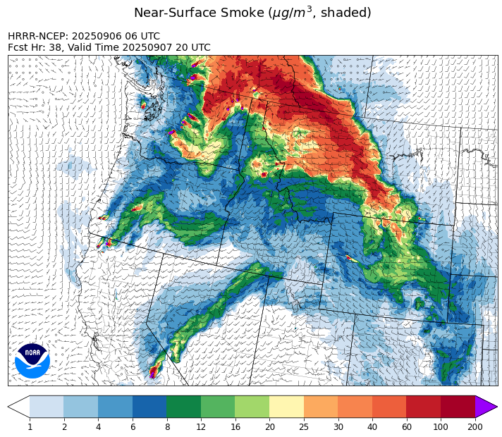
Source: HRRR-smoke
Forecast
High pressure remains parked across the Northern Rockies again on Saturday. It will result in light winds, low humidity, and unseasonably warm temperatures. Numerous active regional wildfires will continue to pump smoke into the state, particularly the western third of Montana where Air Quality Alerts continue through Sunday morning.
By Saturday night and Sunday, the ridge shifts east allowing more of a southwesterly flow across the state. This will pump moist air into the region, setting the stage for scattered showers and storms. There is the threat for new fire starts because of dry thunderstorms and receptive fuels. Gusty afternoon winds should allow many of the sheltered valleys in western Montana to mix out, providing better air quality. The southwesterly flow will also spread smoke from regional wildfires further east and north in the state on Sunday, impacting areas like Great Falls, Butte, Helena, and even Bozeman at times.
A major pattern change looks increasingly likely starting Tuesday. A low-pressure system from the Pacific will move across the state, providing better chances for rain between Tuesday and Thursday. The pattern change will help to moderate fire behavior across the region and reduce smoke production. Stay tuned!
Conditions can change quickly as weather could stimulate active fires and the likelihood of new starts increases. Please keep track of concentrations at todaysair.mtdeq.us or the Fire and Smoke Map.
Saturday morning’s air quality worm plots show trends over the last 48-hours and worsening air quality over parts of western Montana.
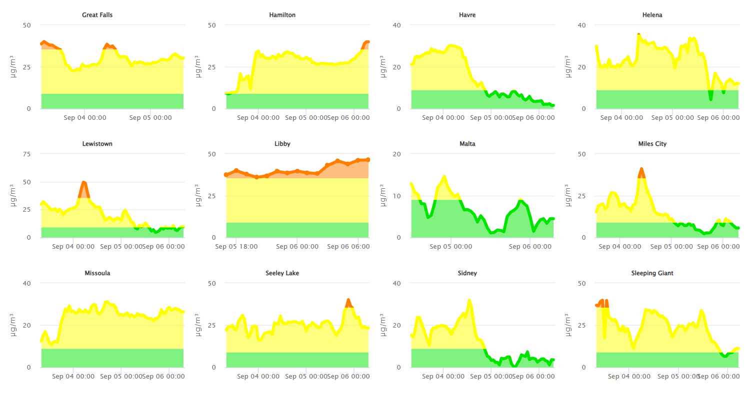
Source: DEQ Analysis
| Incident Name | State | Location | Acres | Containment |
|---|---|---|---|---|
| Ulm Creek Fire - IDIPF | Idaho | NA | 2196 | 0% |
| Big Bear | Idaho | 59 Miles NE of McCall, Idaho - Frank Church-River of No Return Wilderness | 16249 | 70% |
| Rush | Idaho | 57 Miles NW of McCall, Idaho - Frank Church-River of No Return Wilderness | 7908 | 90% |
| Lightning Creek Fire | Idaho | 9 miles north of Clark Fork, ID | 2525 | 25% |
| Shingle | Idaho | NA | 100 | NA |
| Elkhorn Fire | Idaho | 45 Miles E of Challis, ID | 1779 | 0% |
| Cloudrest | Montana | 15 Miles northwest of Virginia City, MT | 3148 | 35% |
| Bivens Creek | Montana | 15 Miles North of Virginia City, MT | 2126 | 94% |
| Windy Rock Fire | Montana | 15 Miles NE of Drummond, MT | 5072 | 9% |
| Knowles Fire | Montana | 11 Miles E of Plains, MT | 3816 | 60% |
| West Fork Fire | Montana | 23 Miles NW of West Yellowstone, MT, Custer Gallatin National Forest | 963 | 83% |
| Timber Butte | Montana | 6 miles west of Dell, MT | 2245 | NA |
| Ransome Fire | Montana | 11 Miles northwest of Libby, MT | 692 | 23% |
| Corral Creek Fire | Montana | 4.5 miles south of Huson, MT | 356 | 92% |
| Sandbar 2 Fire | Montana | 15 miles east of Lincoln, Montana; north of Montana State Highway 279 and Flesher Pass | 243 | 75% |
| McAllister Fire | Montana | Madison County, 3 miles south of Norris, 3 miles north of Ennis Lake | 3560 | 95% |
| Gill Gulch Fire | Montana | 7 Miles south of Lincoln, MT | 34 | 75% |
| Bridge Fire | Oregon | Malheur National Forest, Blue Mountain Ranger District | 350 | 0% |
| Marks Creek | Oregon | 18 miles east of Prineville, Oregon | 1925 | 0% |
| Emigrant Fire | Oregon | 24 miles southeast of Oakridge, Oregon | 31453 | 0% |
| Flat Fire | Oregon | 4 Miles Northeast of Sisters, OR | 23346 | 81% |
| Lynx Mountain | Washington | 7 Miles NW of Inchelium, WA | 2232 | 0% |
| Rattlesnake | Washington | 2 miles West of Seven Bays, WA | 8558 | 0% |
| Martin | Washington | 45 Miles NW of Chelan, WA | 174 | 5% |
| Pomas Fire 2025 | Washington | Approximately 36 miles northwest of Entiat, WA | 3533 | NA |
| Wildcat Fire | Washington | 30 miles West of Naches, WA | 6696 | 0% |
| Crown Creek Fire | Washington | 1 Mile SE of Marble, WA | 13690 | 0% |
| Katy Creek | Washington | 6 Miles NW of Kettle Falls, WA | 2422 | 0% |
| Bear Gulch Fire | Washington | 10 Miles Northwest of Hoodsport, WA | 10275 | 9% |
| Lower Sugarloaf Fire | Washington | 17 miles west of Entiat, WA | 7147 | 0% |
| Labor Mountain Fire | Washington | 10 miles North of Cle Elum, WA | 800 | 0% |
| Tacoma Creek Fire | Washington | 15 miles NW of Cusick, WA | 2335 | 0% |
| Snow Peak | Washington | 19 miles W of Kettle Falls | 280 | 0% |
| Grande Fire | Washington | 12 miles north of Colville | 22 | 65% |
Tags: Smoke Forecast 2025