
Smoke Forecast for Friday, September 5, 2025 9:30 AM
Current Conditions
Montana DEQ is issuing an Air Quality Alert for Beaverhead, Deer Lodge, Granite, Mineral, Missoula, Powell, Ravalli, and Sanders Counties because of elevated particulate levels from wildfire smoke. The alert expires at 9AM Saturday, September 6, 2025.
An Air Resource Advisor has been assigned to the Bivens Creek and Cloudrest fires burning near Twin Bridges in southwest Montana.
Easterly transport winds on Friday should confine the greatest surface smoke concentrations to the western third of the state.
The Ulm Creek fire, burning just west of Trout Creek, Montana, has gained a lot of acreage this week. It has grown to 2,196 acres and is 0% contained. The Knowles fire burning near Paradise, Montana, has burned 3,816 acres. The blaze is now 60% contained. Firefighters have made considerable progress on the Bivens Creek and Cloudrest, burning in the Tobacco Root Mountains. The Bivens Creek fire is now 94% contained, and the Cloudrest fire is 35% contained. The Windy Rock fire, burning 15 miles northeast of Drummond, was active again on Thursday. It has grown to 5,072 acres and is 5% contained. The Ransome fire, burning just north of Libby, was less active on Thursday. It has grown to 686 acres and is 23% contained. There are several active wildfires burning in central and northern Idaho. The biggest of concern for Montana’s air quality are the East, Mire, Rhoda Creek, and Ulm Creek wildfires.
At 9:00 AM Friday, Columbia Falls, Thompson Falls, Frenchtown, Bozeman, Missoula, Hamilton, Dillon, West Yellowstone, Butte, Helena, Sleeping Giant, Great Falls, Cut Bank, Great Falls, Billings, and Broadus’ air quality is Moderate.
By Saturday afternoon, the High-Resolution Rapid Refresh (HRRR) smoke model shows surface smoke covering much of the western third of the state.
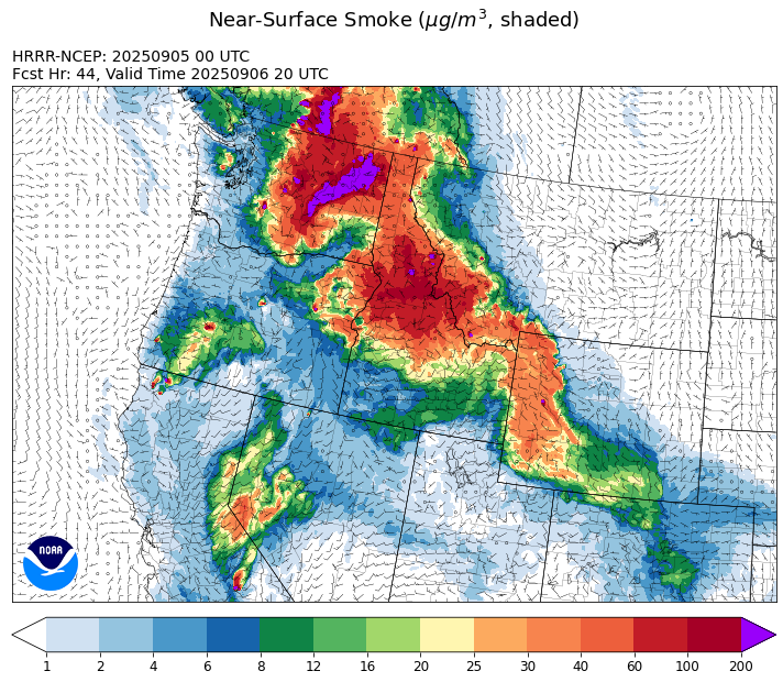
Source: HRRR-smoke
Forecast
High pressure moves a bit further east on Friday. Transport winds will be relatively light and remain out of the east. This will keep the bulk of the surface smoke over the western third of Montana again on Friday. Despite the cooler temperatures, breezy conditions along and ahead of a cold front near the Montana/Idaho border should keep fire behavior active again on Friday.
Starting Saturday, the ridge will shift far enough east to allow a southwesterly flow to return to much of the state. This will pump increasingly moist air into the region, setting the stage for scattered showers and thunderstorms. The southwesterly transport winds will also send smoke from wildfires burning in central and northern Idaho into much of northwest Montana Saturday and Sunday, leading to deteriorating air quality.
Increasingly moist air will lift north into the Treasure State between Monday and Wednesday of next week. This is the period where the valleys have a better opportunity for some beneficial precipitation. Cooler air, higher humidity, and rain will combine to moderate regional wildfire behavior and reduce smoke production. Stay tuned!
Conditions can change quickly as weather could stimulate active fires and the likelihood of new starts increases. Please keep track of concentrations at todaysair.mtdeq.us or the Fire and Smoke Map.
Friday morning’s satellite image shows heavier smoke covering the western third of the state because of regional wildfires.
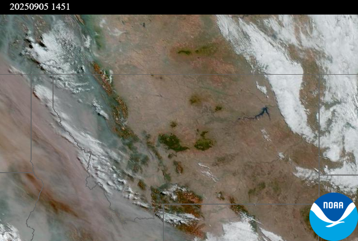
Source: NOAA
| Incident Name | State | Location | Acres | Containment |
|---|---|---|---|---|
| Rock Fire | Idaho | 5 miles southwest of Donnelly, ID | 2796 | 81% |
| Ulm Creek Fire | Idaho | NA | 2196 | 0% |
| Rattle Mountain Fire | Idaho | NA | 50 | 0% |
| Big Bear | Idaho | 59 Miles NE of McCall, Idaho - Frank Church-River of No Return Wilderness | 16249 | 70% |
| Rush | Idaho | 57 Miles NW of McCall, Idaho - Frank Church-River of No Return Wilderness | 7908 | 90% |
| White Pine | Idaho | 14 miles Northeast of Potlatch, Idaho near White Pine Campground and Trailhead | 126 | 0% |
| Twin | Idaho | 29 air miles northeast of Headquarters, ID in Twin Cabin Creek drainage, a tributary to Quartz Creek on the North Fork Ranger District. | 535 | 0% |
| Lightning Creek Fire | Idaho | 9 miles north of Clark Fork, ID | 2525 | 25% |
| Mire | Idaho | Approximately 25 miles west of Powell Idaho and 35 miles northeast of Lowell Idaho | 915 | 0% |
| East | Idaho | 8 miles northwest of Powell Idaho | 788 | 0% |
| Island Creek | Idaho | Near Sob Point on the Moose Creek Ranger District. | 14124 | 5% |
| Elkhorn Fire | Idaho | 45 Miles E of Challis, ID | 1779 | 0% |
| Windy Rock Fire | Montana | 15 Miles NE of Drummond, MT | 5072 | 5% |
| Timber Butte | Montana | 6 miles west of Dell, MT | 2245 | 0% |
| Cloudrest | Montana | 15 Miles northwest of Virginia City, MT | 3148 | 35% |
| West Fork Fire | Montana | 23 Miles NW of West Yellowstone, MT, Custer Gallatin National Forest | 963 | 83% |
| Bivens Creek | Montana | 15 Miles North of Virginia City, MT | 2126 | 94% |
| Ransome Fire | Montana | 11 Miles northwest of Libby, MT | 686 | 23% |
| Knowles Fire | Montana | 11 Miles E of Plains, MT | 3816 | 60% |
| Corral Creek Fire | Montana | 4.5 miles south of Huson, MT | 356 | 92% |
| Sandbar 2 Fire | Montana | 15 miles east of Lincoln, Montana; north of Montana State Highway 279 and Flesher Pass | 243 | 75% |
| McAllister Fire | Montana | Madison County, 3 miles south of Norris, 3 miles north of Ennis Lake | 3560 | 95% |
| Gill Gulch Fire | Montana | 7 Miles south of Lincoln, MT | 34 | 75% |
| Emigrant Fire | Oregon | 24 miles southeast of Oakridge, Oregon | 30576 | 0% |
| Flat Fire | Oregon | 4 Miles Northeast of Sisters, OR | 23346 | 81% |
| Wildcat Fire | Washington | 30 miles West of Naches, WA | 5542 | 0% |
| Rattlesnake | Washington | 2 miles West of Seven Bays, WA | 7675 | 0% |
| Crown Creek Fire | Washington | 1 Mile SE of Marble, WA | 11475 | 0% |
| Bear Gulch Fire | Washington | 10 Miles Northwest of Hoodsport, WA | 10129 | 9% |
| Labor Mountain Fire | Washington | 10 miles North of Cle Elum, WA | 800 | 0% |
| Tacoma Creek Fire | Washington | 15 miles NW of Cusick, WA | 2335 | 0% |
| Lower Sugarloaf Fire | Washington | 17 miles west of Entiat, WA | 7147 | 0% |
| Katy Creek | Washington | 6 Miles NW of Kettle Falls, WA | 1564 | 0% |
| Pomas Fire 2025 | Washington | Approximately 36 miles northwest of Entiat, WA | 3533 | 0% |
| Martin | Washington | 45 Miles NW of Chelan, WA | 132 | 5% |
| Snow Peak | Washington | 19 miles W of Kettle Falls | 280 | 0% |
| Grande Fire | Washington | 12 miles north of Colville | 22 | 65% |
Tags: Smoke Forecast 2025