
Smoke Forecast for Thursday, September 4, 2025 10:00 AM
Current Conditions
Montana DEQ is issuing an Air Quality Alert for Beaverhead, Deer Lodge, Granite, Mineral, Missoula, Powell, Ravalli, and Sanders Counties because of elevated particulate levels from wildfire smoke. The alert expires at 9AM Friday, September 5, 2025.
An Air Resource Advisor has been assigned to the Bivens Creek and Cloudrest fires burning near Twin Bridges in southwest Montana.
Behind a cold front, northeasterly winds will drag down smoke from Canadian wildfires into parts of the state on Thursday.
The Ulm Creek fire, burning just west of Trout Creek, Montana, has gained a lot of acreage this week. It has grown to 1,800 acres and is 0% contained. The Knowles fire burning near Paradise, Montana, has burned 3,822 acres. The blaze is now 52% contained. Firefighters have begun making progress on the Bivens Creek and Cloudrest, burning in the Tobacco Root Mountains. The Bivens Creek fire is now 91% contained, and the Cloudrest fire is 35% contained. The Windy Rock fire, burning 15 miles northeast of Drummond, was very active on Wednesday. It has grown to 5,001 acres and is 2% contained. The Ransome fire, burning just north of Libby, was less active on Wednesday. It has grown to 649 acres and is 23% contained. There are several active wildfires burning in central and northern Idaho. The biggest of concern for Montana’s air quality are the East, Mire, Rhoda Creek, and Ulm Creek wildfires.
At 9:00 AM Thursday, Butte, Seeley Lake, Frenchtown, Missoula, Miles City, Lewistown, Dillon, Hamilton, Helena, Sleeping Giant, Cut Bank, Columbia Falls, Bozeman, West Yellowstone, Billings, Havre, Glendive, Sidney, Broadus, and Glasgow’s air quality is Moderate. Great Falls and Thompson Falls’ air is Unhealthy for Sensitive Groups.
By Friday afternoon, the High-Resolution Rapid Refresh (HRRR) smoke model shows surface smoke covering much of southwest Montana behind a cold front.
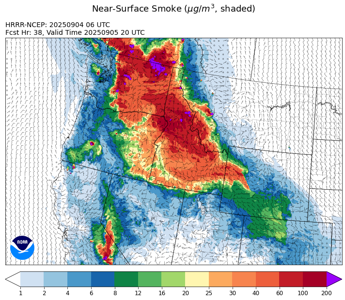
Source: HRRR-smoke
Forecast
A cold front continues to sag slowly south across the state on Thursday. It will bring an end to the unseasonable warmth Montana has experienced the last several days. It will also bring easterly and northeasterly winds to the state, pushing much of the smoke from the numerous wildfires burning in Idaho away from Montana. Unfortunately, strong winds on Thursday will lead to additional fire growth on wildfires in the region. The wind shift will also bring smoke from Alberta and Saskatchewan into the Treasure State. This cooler airmass should stick around through Friday, but winds won’t be nearly as strong.
The ridge of high pressure shifts east towards Montana this weekend, allowing temperatures to quickly moderate. However, this ridge won’t be nearly as amplified as the prior ridge, so temperatures won’t be quite as warm. A southwesterly flow will pump anomalously moist air into the state, setting the stage for scattered showers and storms.
Long-range models keep the southwesterly flow continuing into the following week. This should keep temperatures close to average, while allowing for daily chances for rain and thunderstorms. In general, next week’s pattern should keep regional wildfires in check while reducing smoke production. Stay tuned!
Conditions can change quickly as weather could stimulate active fires and the likelihood of new starts increases. Please keep track of concentrations at todaysair.mtdeq.us or the Fire and Smoke Map.
Thursday morning’s satellite image shows some smoke covering much of the state from numerous regional wildfires in the U.S. and Canada. A cold front is producing clouds over north central and northeast Montana.
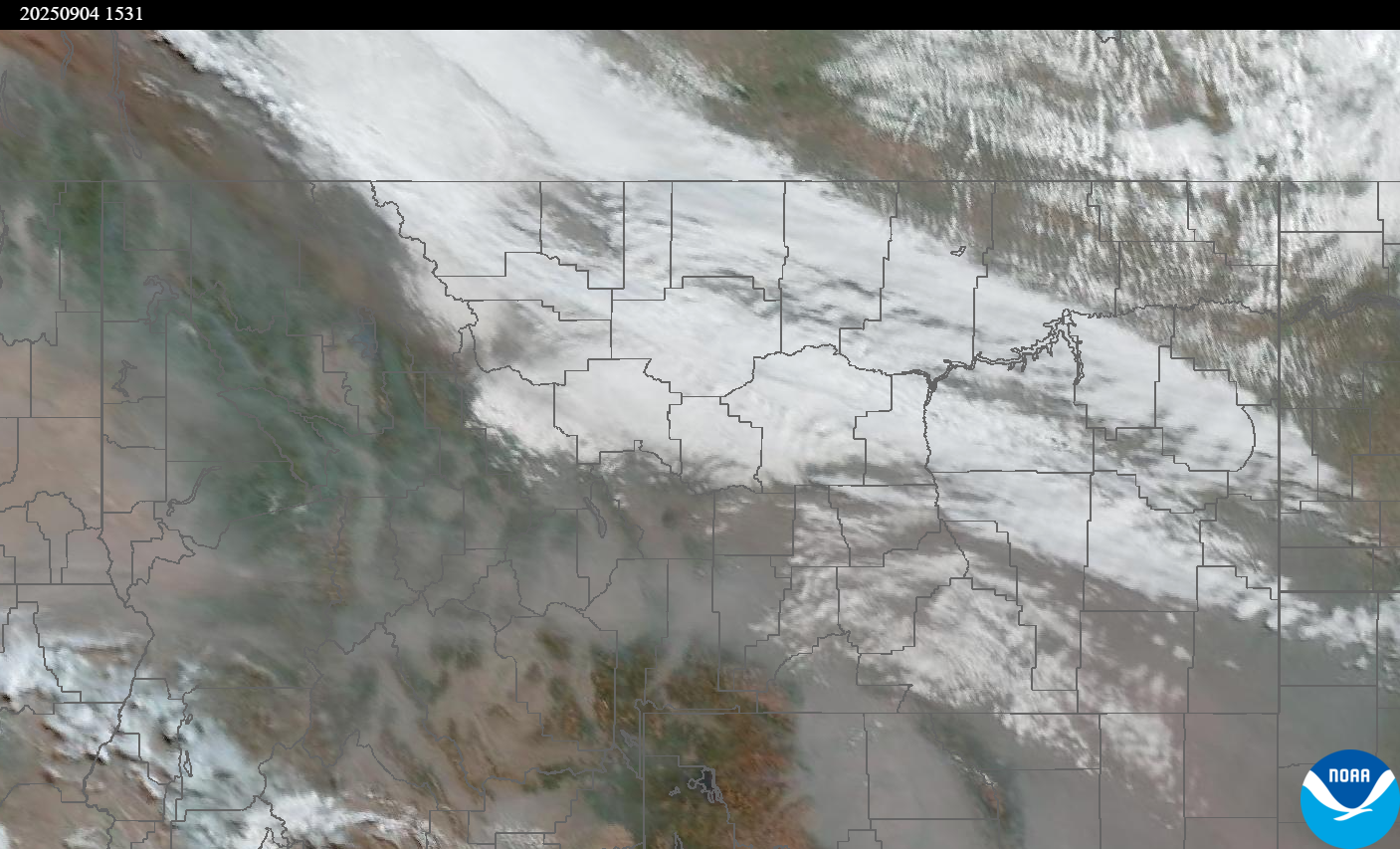
Source: NOAA
| Incident Name | State | Location | Acres | Containment |
|---|---|---|---|---|
| Rock Fire | Idaho | 5 miles southwest of Donnelly, ID | 2796 | 81% |
| Ulm Creek Fire | Idaho | NA | 1800 | 0% |
| Rattle Mountain Fire | Idaho | NA | 50 | 0% |
| Mire | Idaho | Approximately 25 miles west of Powell Idaho and 35 miles northeast of Lowell Idaho | 887 | 0% |
| East | Idaho | 8 miles northwest of Powell Idaho | 760 | 0% |
| Island Creek | Idaho | Near Sob Point on the Moose Creek Ranger District. | 14027 | 5% |
| Twin | Idaho | 29 air miles northeast of Headquarters, ID in Twin Cabin Creek drainage, a tributary to Quartz Creek on the North Fork Ranger District. | 535 | 0% |
| Lightning Creek Fire | Idaho | 9 miles north of Clark Fork, ID | 2525 | 25% |
| Big Bear | Idaho | 59 Miles NE of McCall, Idaho - Frank Church-River of No Return Wilderness | 15517 | 70% |
| Rush | Idaho | 57 Miles NW of McCall, Idaho - Frank Church-River of No Return Wilderness | 7908 | 90% |
| Shingle | Idaho | NA | 100 | 55% |
| Elkhorn Fire | Idaho | 45 Miles E of Challis, ID | 1779 | 0% |
| West Fork Fire | Montana | 23 Miles NW of West Yellowstone, MT, Custer Gallatin National Forest | 963 | 83% |
| Cloudrest | Montana | 15 Miles northwest of Virginia City, MT | 3140 | 35% |
| Bivens Creek | Montana | 15 Miles North of Virginia City, MT | 2126 | 91% |
| Windy Rock Fire | Montana | 15 Miles NE of Drummond, MT | 5001 | 2% |
| Knowles Fire | Montana | 11 Miles E of Plains, MT | 3822 | 52% |
| Ransome Fire | Montana | 11 Miles northwest of Libby, MT | 649 | 23% |
| Corral Creek Fire | Montana | 4.5 miles south of Huson, MT | 356 | 92% |
| Sandbar 2 Fire | Montana | 15 miles east of Lincoln, Montana; north of Montana State Highway 279 and Flesher Pass | 243 | 75% |
| McAllister Fire | Montana | Madison County, 3 miles south of Norris, 3 miles north of Ennis Lake | 3560 | 95% |
| Gill Gulch Fire | Montana | 7 Miles south of Lincoln, MT | 34 | 75% |
| Emigrant Fire | Oregon | 24 miles southeast of Oakridge, Oregon | 30576 | 0% |
| Flat Fire | Oregon | 4 Miles Northeast of Sisters, OR | 23346 | 81% |
| Katy Creek | Washington | 6 Miles NW of Kettle Falls, WA | 1329 | 0% |
| Crown Creek Fire | Washington | 1 Mile SE of Marble, WA | 10740 | 0% |
| Wildcat Fire | Washington | 30 miles West of Naches, WA | 5542 | 0% |
| Rattlesnake | Washington | 2 miles West of Seven Bays, WA | 6052 | 0% |
| Lower Sugarloaf Fire | Washington | 12 miles northeast of Leavenworth, WA | 3700 | 0% |
| Martin | Washington | 45 Miles NW of Chelan, WA | 132 | 5% |
| Pomas Fire 2025 | Washington | Approximately 36 miles northwest of Entiat, WA | 3533 | 0% |
| Bear Gulch Fire | Washington | 10 Miles Northwest of Hoodsport, WA | 9658 | 10% |
| Tacoma Creek | Washington | 15 miles NW of Cusick, WA | 651 | 0% |
| Grande Fire | Washington | 12 miles north of Colville | 22 | 65% |
Tags: Smoke Forecast 2025