
Smoke Forecast for Wednesday, September 3, 2025 10:00 AM
Current Conditions
Montana DEQ is issuing an Air Quality Alert for Flathead, Sanders, Mineral, Glacier, Lake, Lincoln, Missoula, and Powell Counties because of elevated particulate levels from wildfire smoke. The alert expires at 9AM Thursday, September 4, 2025.
An Air Resource Advisor has been assigned to the Bivens Creek and Cloudrest fires burning near Twin Bridges in southwest Montana.
Warmer temperatures and gusty winds will lead to another day with active fire behavior on several wildfires burning across the region.
The Ulm Creek fire, burning just west of Trout Creek, Montana, took off on Tuesday, exhibiting active fire behavior. It has grown to 400 acres and is 0% contained. The Knowles fire burning near Paradise, Montana, has burned 3,822 acres. The blaze is now 52% contained. Firefighters have begun making progress on the Bivens Creek and Cloudrest, burning in the Tobacco Root Mountains. The Bivens Creek fire is now 88% contained, and the Cloudrest fire is 35% contained. The Windy Rock fire, burning 15 miles northeast of Drummond, was less active over the weekend but it continues to slowly grow. It has burned 4,130 acres and is 1% contained. The Ransome fire, burning just north of Libby, remains active. It has grown to 649 acres and is 23% contained. The Island Creek fire, burning in central Idaho, was active again on Tuesday. It has grown to 13,931 acres and is only 5% contained. An incident meteorologist was recently ordered for this fire, highlighting the ongoing concern for this blaze.
At 9:00 AM Wednesday, Thompson Falls, Butte, Seeley Lake, Frenchtown, Missoula, Dillon, Hamilton, Helena, Cut Bank, Columbia Falls, Bozeman, Billings, Havre, Glendive, Sidney, Broadus, and Glasgow’s air quality is Moderate. Great Falls’ air is Unhealthy for Sensitive Groups.
By Thursday afternoon, the High-Resolution Rapid Refresh (HRRR) smoke model shows surface smoke covering much of southwest Montana behind a cold front.
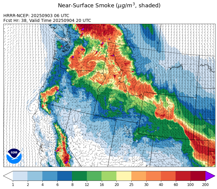
Source: HRRR-smoke
Forecast
High pressure will climax on Wednesday across the Treasure State. It will result in another day with unseasonably warm temperatures, low humidity, and gusty afternoon winds. This will provide ideal conditions for active fire behavior and robust smoke production on regional wildfires. Active wildfires in Idaho and northwest Montana will bring the worst air quality over much of northwest Montana on Wednesday. A cold front dives south across the state starting Wednesday evening. The front will produce gusty winds along and ahead of it.
Behind the cold front, transport winds will be out of the northeast across much of the state starting Thursday. This will push most of the smoke from the wildfires near the Montana/Idaho border into Idaho. However, this flow will also send smoke from Canadian wildfires into much of Montana between Thursday and Friday.
The ridge finally shifts east, allowing a southwesterly flow to return by this weekend. It will bring increasing moisture back into the state along with a slight cooling trend. The pattern will also introduce the potential for some beneficial rainfall. The combination of increased humidity, precipitation, and cooler air should help to moderate fire behavior and limit smoke production on many regional wildfires. Stay tuned!
Conditions can change quickly as weather could stimulate active fires and the likelihood of new starts increases. Please keep track of concentrations at todaysair.mtdeq.us or the Fire and Smoke Map.
Wednesday morning’s satellite image shows some smoke covering much of the state from numerous regional wildfires in the U.S. and Canada.
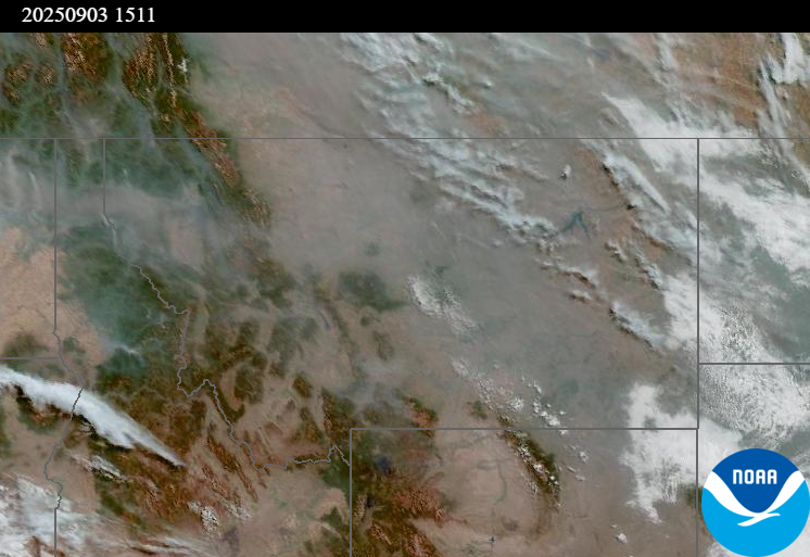
Source: NOAA
| Incident Name | State | Location | Acres | Containment |
|---|---|---|---|---|
| Island Creek | Idaho | Near Sob Point on the Moose Creek Ranger District. | 13931 | 5% |
| Rock Fire | Idaho | 5 miles southwest of Donnelly, ID | 2796 | 74% |
| Ulm Creek Fire | Idaho | NA | 400 | 0% |
| Green Mountain | Idaho | NA | 1 | 0% |
| Twin | Idaho | 29 air miles northeast of Headquarters, ID in Twin Cabin Creek drainage, a tributary to Quartz Creek on the North Fork Ranger District. | 535 | 0% |
| East | Idaho | 8 miles northwest of Powell Idaho | 735 | 0% |
| Mire | Idaho | Approximately 25 miles west of Powell Idaho and 35 miles northeast of Lowell Idaho | 810 | 0% |
| Lightning Creek Fire | Idaho | 9 miles north of Clark Fork, ID | 2525 | 25% |
| Big Bear | Idaho | 59 Miles NE of McCall, Idaho - Frank Church-River of No Return Wilderness | 15517 | 70% |
| Rush | Idaho | 57 Miles NW of McCall, Idaho - Frank Church-River of No Return Wilderness | 7908 | 90% |
| Shingle | Idaho | NA | 100 | 55% |
| Elkhorn Fire | Idaho | 45 Miles E of Challis, ID | 1779 | 0% |
| Windy Rock Fire | Montana | 15 Miles NE of Drummond, MT | 4130 | 1% |
| West Fork Fire | Montana | 23 Miles NW of West Yellowstone, MT, Custer Gallatin National Forest | 963 | 83% |
| Bivens Creek | Montana | 15 Miles North of Virginia City, MT | 2126 | 88% |
| Knowles Fire | Montana | 11 Miles E of Plains, MT | 3822 | 52% |
| Cloudrest | Montana | 15 Miles northwest of Virginia City, MT | 3140 | 35% |
| Corral Creek Fire | Montana | 4.5 miles south of Huson, MT | 356 | 92% |
| Ransome Fire | Montana | 11 Miles northwest of Libby, MT | 649 | 23% |
| Sandbar 2 Fire | Montana | 15 miles east of Lincoln, Montana; north of Montana State Highway 279 and Flesher Pass | 243 | 75% |
| McAllister Fire | Montana | Madison County, 3 miles south of Norris, 3 miles north of Ennis Lake | 3560 | 95% |
| Gill Gulch Fire | Montana | 7 Miles south of Lincoln, MT | 34 | 75% |
| Flat Fire | Oregon | 4 Miles Northeast of Sisters, OR | 23346 | 67% |
| Emigrant Fire | Oregon | 24 miles southeast of Oakridge, Oregon | 23404 | 0% |
| Crown Creek Fire | Washington | 1 Mile SE of Marble, WA | 5718 | 0% |
| Katy Creek | Washington | 6 Miles NW of Kettle Falls, WA | 646 | 0% |
| Rattlesnake | Washington | 30 Miles south of Inchelium, WA | 4210 | 0% |
| Bear Gulch Fire | Washington | 10 Miles Northwest of Hoodsport, WA | 9406 | 10% |
| Martin | Washington | 45 Miles NW of Chelan, WA | 132 | 5% |
| Pomas Fire | Washington | Approximately 36 miles northwest of Entiat, WA | 3533 | 0% |
| Wildcat Fire | Washington | 30 miles West of Naches, WA | 1279 | 0% |
| Tacoma Creek | Washington | 15 miles NW of Cusick, WA | 100 | 0% |
| Grande Fire | Washington | 12 miles north of Colville | 22 | 65% |
Tags: Smoke Forecast 2025