
Smoke Forecast for Friday, September 26, 2025 9:45 AM
Current Conditions
Thanks to unseasonably warm temperatures, low humidity, and gusty afternoon winds, regional wildfire activity increased on Thursday.
The Windy Rock fire, burning 15 miles northeast of Drummond, perked up on Thursday. Westerly transport winds will send some surface smoke into Lewis and Clark County in the coming days. The Windy Rock has grown to 6,096 acres and is 68% contained. The Salmon Forks fire, burning just east of Big Salmon Lake, exhibited active fire behavior on Thursday. The Isabella fire, burning about 20 miles south of Libby, was also active on Thursday. It has burned 1,095 acres and is 0% contained. Westerly transport winds will continue to send smoke into portions of Lincoln and Flathead counties through at least Saturday. There are also numerous active wildfires burning in central Idaho. The most active of the group is the Island Creek fire. It has burned 14,943 acres and is only 7% contained.
At 9:00 AM Friday, Hamilton, Thompson Falls, Missoula, Frenchtown, Helena, Sleeping Giant, Malta, Seeley Lake, and Glasgow’s air quality is Moderate. Columbia Falls’ air is Unhealthy for Sensitive Groups.
By Saturday afternoon, the Rapid Refresh Forecast System (RRFS) smoke model shows heavier surface smoke covering northwest Montana from regional wildfires.
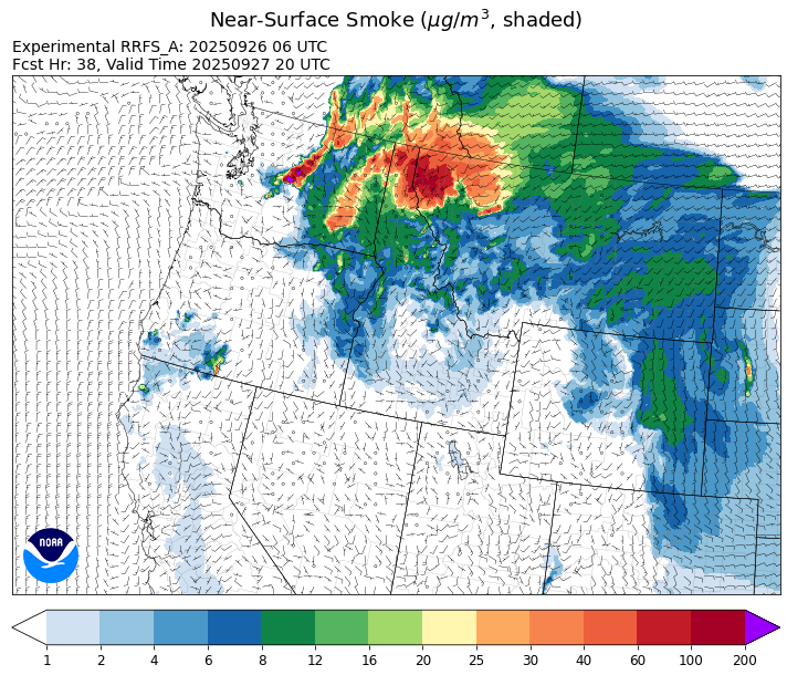
Source: RRFS-smoke
Forecast
Friday will be noticeably cooler and breezier than prior days thanks to a fast-moving cold front. Numerous fires in Montana, Idaho, and Washington have become more active lately, pumping smoke into much of western Montana. The front has very little moisture associated with it and the main impacts from this system will be a short period of increased smoke and gusty afternoon winds. The gusty winds will result in more active fire behavior and increased smoke production on regional wildfires.
A trough of low pressure digs off the coast of Washington and Oregon this weekend. It will force a ridge of high pressure to build over the Treasure State. The ridge will allow temperatures to slowly moderate over the weekend and highs will once again reach 10-15 degrees above normal. Expect the usual diurnal impacts to smoke production as smoke drains and pools overnight, bringing deteriorating air quality to communities adjacent to active wildfires.
The trough gradually moves into Montana late Sunday and Monday. Chances for thunderstorms will increase each day through Wednesday. Clouds, cooler temperatures, and precipitation should help to moderate fire behavior and decrease smoke production. Stay tuned!
Conditions can change quickly as weather could stimulate active fires and the likelihood of new starts increases. Please keep track of concentrations at todaysair.mtdeq.us or the Fire and Smoke Map.
Thursday afternoon’s satellite image shows numerous active wildfires burning in Washington, Idaho, and Montana.
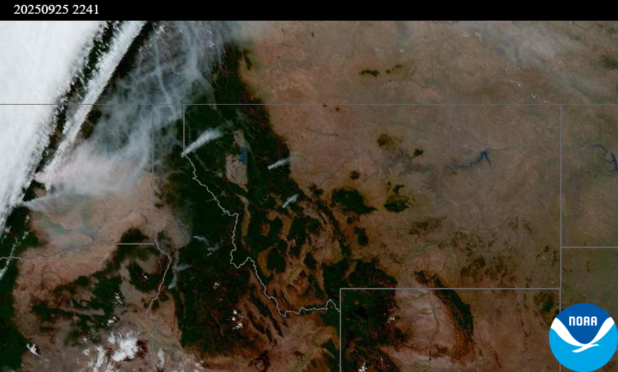
Source: NOAA
| Incident Name | State | Location | Acres | Containment |
|---|---|---|---|---|
| Island Creek | Idaho | 14 Miles N of Elk City, ID | 14943 | 7% |
| White Pine | Idaho | 7 Miles NE of Harvard, ID near White Pine Campground and Trailhead | 1045 | 81% |
| Sheep Drive | Idaho | 10 miles east/northeast of Elk City Idaho | 140 | NA |
| Twin | Idaho | 29 air miles northeast of Headquarters, ID in Twin Cabin Creek drainage, a tributary to Quartz Creek on the North Fork Ranger District. | 1100 | NA |
| Lightning Creek Fire | Idaho | 9 miles north of Clark Fork, ID | 2525 | 25% |
| Rock Fire | Idaho | 5 miles southwest of Donnelly, ID | 2796 | 97% |
| Green Rattle Complex | Idaho | NA | 571 | 10% |
| Ulm Creek Fire | Idaho | 16 miles north of Prichard, ID and 10 miles south of Heron, MT. | 2929 | 10% |
| East | Idaho | 8 miles northwest of Powell Idaho | 2231 | 50% |
| Mire | Idaho | Approximately 25 miles west of Powell Idaho and 35 miles northeast of Lowell Idaho | 1388 | 70% |
| Green Mtn Fire | Idaho | 8 miles West/Southwest of Clark Fork, ID | 83 | 8% |
| Rattle Mountain Fire | Idaho | 13 miles North/Northeast of Clark Fork, ID | 122 | 8% |
| Rush | Idaho | 57 Miles NW of McCall, Idaho - Frank Church-River of No Return Wilderness | 7908 | 90% |
| Big Bear | Idaho | 59 Miles NE of McCall, Idaho - Frank Church-River of No Return Wilderness | 16220 | 90% |
| Elkhorn Fire | Idaho | Krassel Ranger District, Payette National Forest | 26048 | NA |
| Windy Rock Fire | Montana | 15 Miles NE of Drummond, MT | 6096 | 68% |
| Cloudrest | Montana | 15 Miles northwest of Virginia City, MT | 3174 | 54% |
| Isabella and Lost Girl Fires | Montana | NA | 1095 | 0% |
| West Fork Fire | Montana | 23 Miles NW of West Yellowstone, MT, Custer Gallatin National Forest | 963 | 83% |
| Ransome Fire | Montana | 11 Miles northwest of Libby, MT | 704 | 53% |
| McAllister Fire | Montana | Madison County, 3 miles south of Norris, 3 miles north of Ennis Lake | 3560 | 95% |
| Gill Gulch Fire | Montana | 7 Miles south of Lincoln, MT | 34 | 75% |
| Moon Complex | Oregon | 11 Miles northeast of Agness, OR | 5618 | 10% |
| Foley Ridge Fire | Oregon | 7 miles SE of McKenzie Bridge, OR | 497 | 46% |
| Emigrant Fire | Oregon | 24 miles southeast of Oakridge, Oregon | 32801 | 41% |
| Kelsey Peak Fire | Oregon | 15 miles west of Glendale, Oregon | 1039 | 97% |
| Black Rock Fire | Oregon | 13 miles west of Fossil, OR | 43842 | 80% |
| Marks Creek | Oregon | 18 miles east of Prineville, Oregon | 1718 | 88% |
| Tacoma Creek Fire | Washington | 15 miles NW of Cusick, WA | 3961 | 90% |
| Labor Mountain Fire | Washington | 10 miles North of Cle Elum, WA | 25327 | 7% |
| Lower Sugarloaf Fire | Washington | 12 miles northeast of Leavenworth, WA | 34695 | 32% |
| Crown Creek Fire | Washington | 1 Mile SE of Marble, WA | 14192 | 93% |
| Katy Creek | Washington | 6 Miles NW of Kettle Falls, WA | 4680 | 93% |
| Rattlesnake | Washington | 2 miles West of Seven Bays, WA | 21845 | 96% |
| Lynx Mountain | Washington | 7 Miles NW of Inchelium, WA | 9168 | 60% |
| Wildcat Fire | Washington | 30 miles West of Naches, WA | 9574 | 7% |
| Tunnel Creek Fire | Washington | NA | 558 | 0% |
| Pomas Fire | Washington | Approximately 36 miles northwest of Entiat, WA | 3533 | 45% |
| Martin | Washington | 45 Miles NW of Chelan, WA | 188 | 50% |
| Bear Gulch Fire | Washington | 10 Miles Northwest of Hoodsport, WA | 19981 | 5% |
| Perry Fire | Washington | 16 miles NE of Newhalem, WA, west of Ross Lake | 1772 | 61% |
| Snow Peak | Washington | 19 miles W of Kettle Falls | 1100 | 0% |
| Sugar | Washington | 5 Miles NE of Conconully, WA | 96 | 75% |
Tags: Smoke Forecast 2025