
Smoke Forecast for Tuesday, September 2, 2025 10:00 AM
Current Conditions
Montana DEQ is issuing an Air Quality Alert for Dawson, Daniels, McCone, Richland, Roosevelt, Sheridan, and Valley Counties because of elevated particulate levels from wildfire smoke. The alert expires at 9AM Wednesday, September 3, 2025.
An Air Resource Advisor has been assigned to the Bivens Creek and Cloudrest fires burning near Twin Bridges in southwest Montana.
Warmer air, lower humidity, and gusty winds led to more active fire behavior on multiple wildfires over the holiday weekend.
The Knowles fire burning near Paradise, Montana, has burned 3,822 acres. Recent precipitation has helped firefighting efforts, and the blaze is now 52% contained. Firefighters have begun making progress on the Bivens Creek and Cloudrest, burning in the Tobacco Root Mountains. The Bivens Creek fire is now 76% contained, and the Cloudrest fire is 20% contained. The West Fork fire, burning just north of Hebgen Lake, was less active over the weekend. The fire has burned 954 acres and is now 75% contained. The Windy Rock fire, burning 15 miles northeast of Drummond, was less active over the weekend, but it continues to slowly grow. It has burned 4,022 acres and is 0% contained. The Ransome fire, burning just north of Libby, remained active over the weekend. It has grown to 649 acres and is 23% contained. The Island Creek fire, burning in central Idaho, was active over the weekend. It has grown to 13,891 acres and is only 5% contained. An incident meteorologist was recently ordered for this fire, highlighting the ongoing concern for this blaze.
At 9:00 AM Thursday, Thompson Falls, Cut Bank, Columbia Falls, Frenchtown, Missoula, Dillon, Helena, Great Falls, Lewistown, Billings, Bozeman, Havre, Sidney, and Broadus' air quality is Moderate. Glendive's air is Unhealthy for Sensitive Groups. Glasgow's air is Unhealthy.
By Wednesday afternoon, the High-Resolution Rapid Refresh (HRRR) smoke model shows light surface smoke covering much of the state from Canadian and local wildfires.
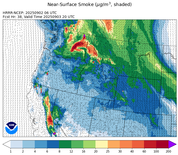
Source: HRRR-smoke
Forecast
Transport winds will be out of the north on Monday. This will send surface smoke from Canadian wildfires south into Montana in the coming days. In addition to the Canadian wildfires smoke, the western half of Montana will continue to deal with the impacts from the Ransome, Windy Rock, and Island Creek fires. High pressure will dominate the weather story in the coming days. The combination of unseasonably warm air, dry fuels, and gusty afternoon winds will lead to active fire weather behavior on many regional fires.
A northerly flow will keep at least some Canadian wildfire smoke over the region through Wednesday. By Thursday and Friday easterly and northeasterly transport winds are likely for much of the state. This will send smoke from Canadian wildfires south and west into most of Montana.
Long-range forecast models continue to advertise more of a southwesterly flow developing by this weekend. This will start a gradual cooling process for the region. More importantly for fire weather behavior and smoke production, the pattern will also increase moisture and bring better chances for showers and thunderstorms.
Conditions can change quickly as weather could stimulate active fires and the likelihood of new starts increases. Please keep track of concentrations at todaysair.mtdeq.us or the Fire and Smoke Map.
Tuesday morning’s satellite image shows some smoke covering northeast Montana because of Canadian wildfires.
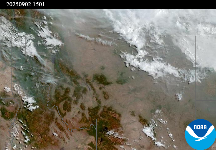
Source: NOAA
| Incident Name | State | Location | Acres | Containment |
|---|---|---|---|---|
| Rock Fire | Idaho | 5 miles southwest of Donnelly, ID | 2796 | 74% |
| White Pine | Idaho | 14 miles Northeast of Potlatch, Idaho near White Pine Campground and Trailhead | 13 | NA |
| Twin | Idaho | 29 air miles northeast of Headquarters, ID in Twin Cabin Creek drainage, a tributary to Quartz Creek on the North Fork Ranger District. | 272 | 0% |
| East | Idaho | 8 miles northwest of Powell Idaho | 735 | 0% |
| Mire | Idaho | Approximately 25 miles west of Powell Idaho and 35 miles northeast of Lowell Idaho | 810 | 0% |
| Island Creek | Idaho | Near Sob Point on the Moose Creek Ranger District. | 13891 | 5% |
| Sunset Fire | Idaho | 26 Miles N of Coeur d'Alene, ID | 3183 | 94% |
| Lightning Creek Fire | Idaho | 9 miles north of Clark Fork, ID | 2525 | 25% |
| Big Bear | Idaho | 59 Miles NE of McCall, Idaho - Frank Church-River of No Return Wilderness | 15517 | 70% |
| Rush | Idaho | 57 Miles NW of McCall, Idaho - Frank Church-River of No Return Wilderness | 7908 | 90% |
| Shingle | Idaho | NA | 100 | 55% |
| Cedar Fire | Idaho | approximately 4 miles northeast of Clyde | 898 | 90% |
| Elkhorn Fire | Idaho | 45 Miles E of Challis, ID | 1629 | 0% |
| Windy Rock Fire | Montana | 15 Miles NE of Drummond, MT | 4022 | 0% |
| Bivens Creek | Montana | 15 Miles North of Virginia City, MT | 2126 | 76% |
| Cloudrest | Montana | 15 Miles northwest of Virginia City, MT | 3135 | 20% |
| Ransome Fire | Montana | 11 Miles northwest of Libby, MT | 649 | 23% |
| Knowles Fire | Montana | 11 Miles E of Plains, MT | 3822 | 52% |
| Corral Creek Fire | Montana | 4.5 miles south of Huson, MT | 356 | 92% |
| West Fork Fire | Montana | 23 Miles NW of West Yellowstone, MT, Custer Gallatin National Forest | 954 | 75% |
| Sandbar 2 Fire | Montana | 15 miles east of Lincoln, Montana; north of Montana State Highway 279 and Flesher Pass | 243 | 75% |
| McAllister Fire | Montana | Madison County, 3 miles south of Norris, 3 miles north of Ennis Lake | 3560 | 95% |
| Gill Gulch Fire | Montana | 7 Miles south of Lincoln, MT | 34 | 75% |
| Flat Fire | Oregon | 4 Miles Northeast of Sisters, OR | 23346 | 52% |
| Emigrant Fire | Oregon | 24 miles southeast of Oakridge, Oregon | 21959 | 0% |
| Martin | Washington | 45 Miles NW of Chelan, WA | 122 | 5% |
| Pomas Fire | Washington | Approximately 36 miles northwest of Entiat, WA | 3533 | 0% |
| Bear Gulch Fire | Washington | 10 Miles Northwest of Hoodsport, WA | 9388 | 10% |
| Katy Creek | Washington | 6 Miles NW of Kettle Falls, WA | 338 | 0% |
| Crown Creek Fire | Washington | 1 Mile SE of Marble, WA | 3193 | 0% |
| Wildcat Fire | Washington | 30 miles West of Naches, WA | 1170 | 0% |
| Grande Fire | Washington | 12 miles north of Colville | 22 | 65% |
Tags: Smoke Forecast 2025