
Smoke Forecast for Monday, September 15, 2025 10:00 AM
Current Conditions
An area of low pressure will shift east across the state on Monday, providing showers and cooler temperatures.
The Ulm Creek fire, burning just west of Trout Creek, Montana, received some rain over the weekend. It has grown to 2,928 acres and is 10% contained. The Isabella fire, burning in the Cabinet Mountains just north of Noxon, remains active despite recent precipitation. It has burned 859 acres and is 0% contained. The Windy Rock fire, burning 15 miles northeast of Drummond, remains active despite recent precipitation. The Windy Rock has grown to 6,025 acres and is 43% contained. The Ransome fire, burning just north of Libby, was less active over the weekend. It has grown to 701 acres and is 31% contained. The Timber Butte fire, burning just west of Dell, Montana, was less active over the weekend. It has burned 2,245 acres and is 70% contained. There are several active wildfires burning in central and northern Idaho. The biggest of concern for Montana’s air quality are the Walk, Rhoda Creek, and Twin wildfires. Despite recent precipitation, fire activity remains moderate on these wildfires.
At 9:00 AM Monday, Libby, Columbia Falls, Sleeping Giant, and Broadus’ air quality is Moderate.
By Tuesday afternoon, the High-Resolution Rapid Refresh (HRRR) smoke model shows light surface smoke much of the state from Canadian wildfires.
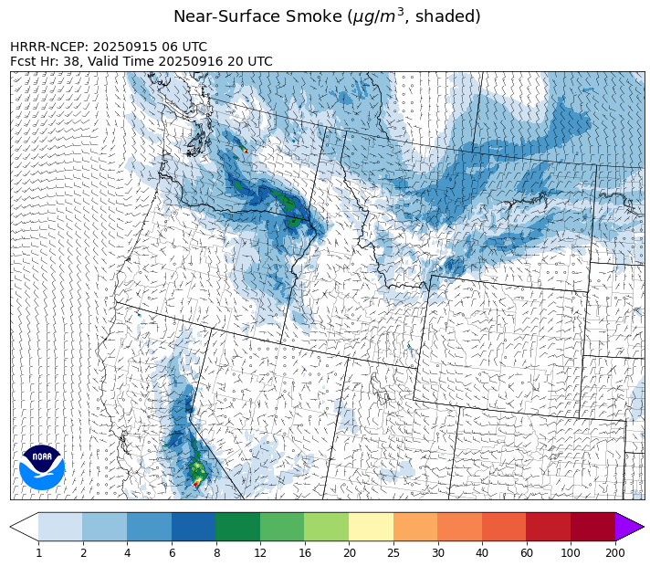
Source: HRRR-smoke
Forecast
Low pressure over Montana on Monday shifts east, bringing additional precipitation and much cooler air. Much of the region received beneficial precipitation over the weekend, helping to moderate fire behavior and limit smoke production. Northerly transport winds will keep some light surface smoke across much of the state from Canadian wildfires through Tuesday.
Ridging will build over the state beginning on Tuesday. It will provide mainly dry conditions for the state, with high temperatures running between 5-10 degrees above normal. Fire activity will perk up on regional wildfires in this pattern. However, a decreasing fall sun angle is reducing solar radiation and should help limit acres burned in the coming days.
By the upcoming weekend, a southwesterly flow will return to the Treasure State. It will pump monsoonal moisture into the region. This will provide scattered afternoon showers and thunderstorms across the state. It will also produce slightly cooler temperatures and gusty afternoon winds. Stay tuned!
Conditions can change quickly as weather could stimulate active fires and the likelihood of new starts increases. Please keep track of concentrations at todaysair.mtdeq.us or the Fire and Smoke Map.
Monday morning’s satellite image shows clouds covering much of the state thanks to an upper-level area of low pressure.
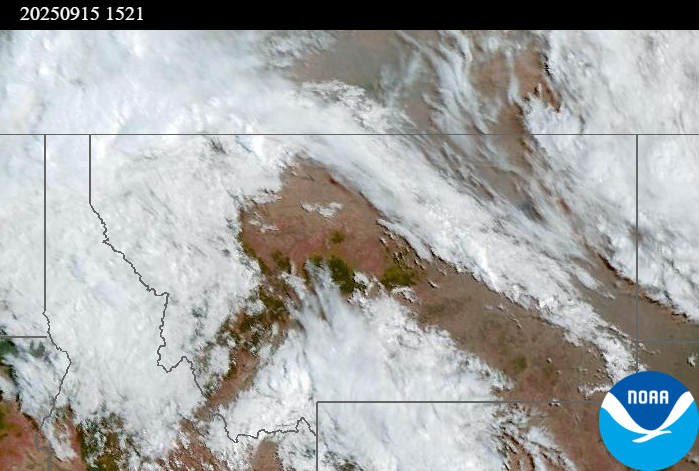
Source: NOAA
| Incident Name | State | Location | Acres | Containment |
|---|---|---|---|---|
| White Pine | Idaho | 7 Miles NE of Harvard, ID near White Pine Campground and Trailhead | 1045 | 10% |
| East | Idaho | 8 miles northwest of Powell Idaho | 2209 | 0% |
| Mire | Idaho | Approximately 25 miles west of Powell Idaho and 35 miles northeast of Lowell Idaho | 1388 | 0% |
| Island Creek | Idaho | 14 Miles N of Elk City, ID | 14938 | 5% |
| Green Rattle Complex | Idaho | NA | 541 | 0% |
| Rattle Mountain Fire | Idaho | 13 miles North/Northeast of Clark Fork, ID | 122 | 0% |
| Green Mtn Fire | Idaho | 8 miles West/Southwest of Clark Fork, ID | 69 | 0% |
| Ulm Creek Fire | Idaho | 16 miles north of Prichard, ID and 10 miles south of Heron, MT. | 2928 | 10% |
| Rock Fire | Idaho | 5 miles southwest of Donnelly, ID | 2796 | 95% |
| Rush | Idaho | 57 Miles NW of McCall, Idaho - Frank Church-River of No Return Wilderness | 7908 | 90% |
| Big Bear | Idaho | 59 Miles NE of McCall, Idaho - Frank Church-River of No Return Wilderness | 16220 | 90% |
| Twin | Idaho | 29 air miles northeast of Headquarters, ID in Twin Cabin Creek drainage, a tributary to Quartz Creek on the North Fork Ranger District. | 850 | 0% |
| Lightning Creek Fire | Idaho | 9 miles north of Clark Fork, ID | 2525 | 25% |
| Shingle | Idaho | NA | 100 | 55% |
| Elkhorn Fire | Idaho | 45 Miles E of Challis, ID | 1779 | 0% |
| Windy Rock Fire | Montana | 15 Miles NE of Drummond, MT | 6025 | 43% |
| Isabella and Lost Girl Fires | Montana | NA | 859 | 0% |
| West Fork Fire | Montana | 23 Miles NW of West Yellowstone, MT, Custer Gallatin National Forest | 963 | 83% |
| Cloudrest | Montana | 15 Miles northwest of Virginia City, MT | 3174 | 54% |
| Timber Butte | Montana | 6 miles west of Dell, MT | 2245 | 70% |
| Ransome Fire | Montana | 11 Miles northwest of Libby, MT | 701 | 31% |
| McAllister Fire | Montana | Madison County, 3 miles south of Norris, 3 miles north of Ennis Lake | 3560 | 95% |
| Gill Gulch Fire | Montana | 7 Miles south of Lincoln, MT | 34 | 75% |
| Kelsey Peak Fire | Oregon | 15 miles west of Glendale, Oregon | 1039 | 68% |
| Bridge Fire | Oregon | Malheur National Forest, Blue Mountain Ranger District | 350 | 98% |
| Emigrant Fire | Oregon | 24 miles southeast of Oakridge, Oregon | 32347 | 34% |
| Moon Complex | Oregon | 11 Miles NE of Agness, OR | 3958 | 6% |
| Foley Ridge Fire | Oregon | McKenzie River Highway | 414 | 0% |
| Black Rock Fire | Oregon | 13 miles west of Fossil, OR | 43842 | 80% |
| Marks Creek | Oregon | 18 miles east of Prineville, Oregon | 1718 | 88% |
| Flat Fire | Oregon | 4 Miles Northeast of Sisters, OR | 23346 | 81% |
| Wildcat Fire | Washington | 30 miles West of Naches, WA | 8415 | 8% |
| Rattlesnake | Washington | 2 miles West of Seven Bays, WA | 21844 | 85% |
| Lynx Mountain | Washington | 7 Miles NW of Inchelium, WA | 7839 | 22% |
| Katy Creek | Washington | 6 Miles NW of Kettle Falls, WA | 3895 | 10% |
| Crown Creek Fire | Washington | 1 Mile SE of Marble, WA | 14190 | 30% |
| Tacoma Creek Fire | Washington | 15 miles NW of Cusick, WA | 3930 | 36% |
| Martin | Washington | 45 Miles NW of Chelan, WA | 175 | 5% |
| Pomas Fire | Washington | Approximately 36 miles northwest of Entiat, WA | 3533 | 0% |
| Perry Fire | Washington | 16 miles NE of Newhalem, WA, west of Ross Lake | 1763 | 40% |
| Labor Mountain Fire | Washington | 10 miles North of Cle Elum, WA | 4797 | 0% |
| Lower Sugarloaf Fire | Washington | 12 miles northeast of Leavenworth, WA | 17298 | 0% |
| Bear Gulch Fire | Washington | 10 Miles Northwest of Hoodsport, WA | 10843 | 9% |
| Snow Peak | Washington | 19 miles W of Kettle Falls | 754 | 0% |
| Sugar | Washington | 5 Miles NE of Conconully, WA | 96 | 75% |
Tags: Smoke Forecast 2025