
Smoke Forecast for Friday, September 12, 2025 9:00 AM
Current Conditions
Low pressure will crawl slowly across the state Friday and into the weekend, producing scattered showers and a few storms.
The Ulm Creek fire, burning just west of Trout Creek, Montana, is much less active than the prior week. It has grown to 2,847 acres and is 10% contained. The Isabella fire, burning in the Cabinet Mountains just north of Noxon, remains active. It has burned 770 acres and is 0% contained. The Devil Mountain and Windy Rock fires, burning 15 miles northeast of Drummond, were active again on Thursday despite the higher humidity and precipitation. The Devil Mountain fire has burned 1,932 acres and the Windy Rock has grown to 6,022 acres and is 32% contained. The Ransome fire, burning just north of Libby, remained active on Thursday. It has grown to 701 acres and is 31% contained. The Timber Butte fire, burning just west of Dell, Montana, was less active on Thursday. It has burned 2,245 acres and is 70% contained. There are several active wildfires burning in central and northern Idaho. The biggest of concern for Montana’s air quality are the East, Mire, Twin, Rhoda Creek, Big Bear, and Island Creek wildfires. Despite recent precipitation, fire activity remains moderate on most of these wildfires.
At 9:00 AM Friday, Libby, Great Falls, Malta, Sidney, Glasgow, and Broadus’ air quality is Moderate.
By Saturday afternoon, the High-Resolution Rapid Refresh (HRRR) smoke model shows light surface smoke covering northwest Montana from regional wildfires.
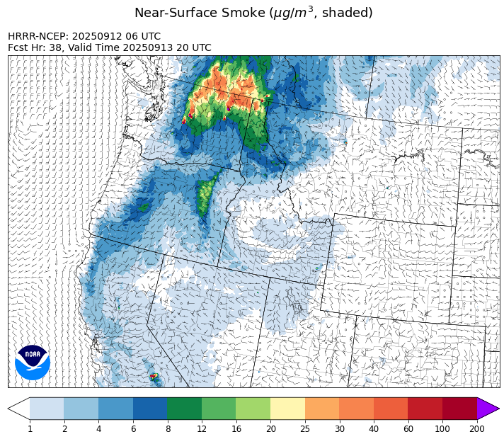
Source: HRRR-smoke
Forecast
Scattered showers and storms are possible once again over much of the state on Friday. Despite the recent precipitation and higher humidity levels, numerous fires in Idaho and western Montana remain active. Precipitation will become more widespread Friday afternoon thanks to the destabilizing influences from the afternoon sun.
By Saturday, the low moves into eastern Montana. It will generate widely isolated showers and storms, but much of the weekend will be dry for the valleys. On Sunday, if there’s enough clearing, there could be some pockets of morning fog. Some light surface smoke from regional wildfires will be transported into western Montana over the weekend.
Longer range models continue to advertise another trough moving into the area Sunday afternoon and Monday. It will produce a round of showers and storms across the Treasure State. Higher humidity, precipitation, and a decreasing fall sun angle should moderate fire behavior and limit smoke production. By Tuesday and Wednesday, a transient ridge builds, providing warmer temperatures and lower humidity. This could lead to more active fire behavior on regional wildfires. Stay tuned!
Conditions can change quickly as weather could stimulate active fires and the likelihood of new starts increases. Please keep track of concentrations at todaysair.mtdeq.us or the Fire and Smoke Map.
Friday morning’s satellite image shows clouds covering much of the state thanks to an upper-level area of low pressure.
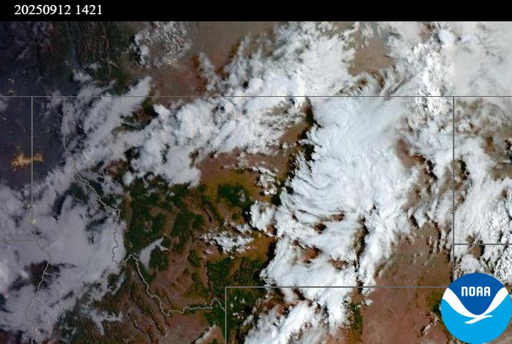
Source: NOAA
| Incident Name | State | Location | Acres | Containment |
|---|---|---|---|---|
| Green Mtn Fire | Idaho | 8 miles West/Southwest of Clark Fork, ID | 35 | 0% |
| Rattle Mountain Fire | Idaho | 13 miles North/Northeast of Clark Fork, ID | 115 | 0% |
| Green Rattle Complex | Idaho | NA | 458 | NA |
| Island Creek | Idaho | 14 Miles N of Elk City, ID | 14802 | 5% |
| Mire | Idaho | Approximately 25 miles west of Powell Idaho and 35 miles northeast of Lowell Idaho | 1321 | 0% |
| East | Idaho | 8 miles northwest of Powell Idaho | 2114 | 0% |
| Rock Fire | Idaho | 5 miles southwest of Donnelly, ID | 2796 | 95% |
| White Pine | Idaho | 7 Miles NE of Harvard, ID near White Pine Campground and Trailhead | 1031 | 10% |
| Rush | Idaho | 57 Miles NW of McCall, Idaho - Frank Church-River of No Return Wilderness | 7908 | 90% |
| Big Bear | Idaho | 59 Miles NE of McCall, Idaho - Frank Church-River of No Return Wilderness | 16220 | 90% |
| Ulm Creek Fire | Idaho | 16 miles north of Prichard, ID and 10 miles south of Heron, MT. | 2847 | 10% |
| Twin | Idaho | 29 air miles northeast of Headquarters, ID in Twin Cabin Creek drainage, a tributary to Quartz Creek on the North Fork Ranger District. | 850 | 0% |
| Lightning Creek Fire | Idaho | 9 miles north of Clark Fork, ID | 2525 | 25% |
| Shingle | Idaho | NA | 100 | 55% |
| Elkhorn Fire | Idaho | 45 Miles E of Challis, ID | 1779 | 0% |
| Windy Rock Fire | Montana | 15 Miles NE of Drummond, MT | 6022 | 32% |
| Cloudrest | Montana | 15 Miles northwest of Virginia City, MT | 3148 | 54% |
| Ransome Fire | Montana | 11 Miles northwest of Libby, MT | 701 | 31% |
| Isabella and Lost Girl Fires | Montana | NA | 770 | 0% |
| Timber Butte | Montana | 6 miles west of Dell, MT | 2245 | 70% |
| West Fork Fire | Montana | 23 Miles NW of West Yellowstone, MT, Custer Gallatin National Forest | 963 | 83% |
| Sandbar 2 Fire | Montana | 15 miles east of Lincoln, Montana; north of Montana State Highway 279 and Flesher Pass | 243 | 75% |
| McAllister Fire | Montana | Madison County, 3 miles south of Norris, 3 miles north of Ennis Lake | 3560 | 95% |
| Gill Gulch Fire | Montana | 7 Miles south of Lincoln, MT | 34 | 75% |
| Emigrant Fire | Oregon | 24 miles southeast of Oakridge, Oregon | 32294 | 21% |
| Bridge Fire | Oregon | Malheur National Forest, Blue Mountain Ranger District | 350 | 62% |
| Foley Ridge Fire | Oregon | McKenzie River Highway | 249 | 0% |
| Moon Complex | Oregon | 11 Miles NE of Agness, OR | 3910 | 4% |
| Kelsey Peak Fire | Oregon | 15 miles west of Glendale, Oregon | 1036 | 15% |
| Black Rock Fire | Oregon | 13 miles west of Fossil, OR | 43842 | 60% |
| Marks Creek | Oregon | 18 miles east of Prineville, Oregon | 1718 | 72% |
| Flat Fire | Oregon | 4 Miles Northeast of Sisters, OR | 23346 | 81% |
| Crown Creek Fire | Washington | 1 Mile SE of Marble, WA | 14235 | 25% |
| Katy Creek | Washington | 6 Miles NW of Kettle Falls, WA | 3585 | 10% |
| Lower Sugarloaf Fire | Washington | 12 miles northeast of Leavenworth, WA | 14323 | 0% |
| Wildcat Fire | Washington | 30 miles West of Naches, WA | 7930 | 8% |
| Tacoma Creek Fire | Washington | 15 miles NW of Cusick, WA | 3796 | 0% |
| Lynx Mountain | Washington | 7 Miles NW of Inchelium, WA | 5033 | 7% |
| Rattlesnake | Washington | 2 miles West of Seven Bays, WA | 21338 | 65% |
| Labor Mountain Fire | Washington | 10 miles North of Cle Elum, WA | 3934 | 0% |
| Sugar | Washington | 5 Miles NE of Conconully, WA | 96 | 75% |
| Martin | Washington | 45 Miles NW of Chelan, WA | 175 | 5% |
| Perry Fire | Washington | 16 miles NE of Newhalem, WA, west of Ross Lake | 1763 | 0% |
| Bear Gulch Fire | Washington | 10 Miles Northwest of Hoodsport, WA | 10629 | 9% |
| Pomas Fire | Washington | Approximately 36 miles northwest of Entiat, WA | 3533 | 0% |
| Snow Peak | Washington | 19 miles W of Kettle Falls | 700 | 0% |
Tags: Smoke Forecast 2025