
Smoke Forecast for Thursday, September 11, 2025 9:30 AM
Current Conditions
An area of low pressure will crawl slowly across the state, producing beneficial precipitation and helping to reduce smoke production on regional wildfires.
The Ulm Creek fire, burning just west of Trout Creek, Montana, is much less active than the prior week. It has grown to 2,713 acres and is 10% contained. The Isabella fire, burning in the Cabinet Mountains just north of Noxon, remains active. It has burned 770 acres and is 0% contained. The Devil Mountain and Windy Rock fires, burning 15 miles northeast of Drummond, were active again on Wednesday despite the higher humidity and precipitation. The Devil Mountain fire has burned 1,932 acres and the Windy Rock has grown to 6,031 acres and is 26% contained. The Ransome fire, burning just north of Libby, remained active on Wednesday. It has grown to 701 acres and is 31% contained. The Timber Butte fire, burning just west of Dell, Montana, was less active on Wednesday. It has burned 2,245 acres and is 70% contained. There are several active wildfires burning in central and northern Idaho. The biggest of concern for Montana’s air quality are the East, Mire, Twin, Rhoda Creek, Big Bear, and Island Creek wildfires. Despite recent precipitation, fire activity remains moderate on most of these wildfires.
At 9:00 AM Thursday, Helena, Great Falls, Cut Bank, Columbia Falls, Malta, and Sidney's air quality is Moderate.
By Friday afternoon, the High-Resolution Rapid Refresh (HRRR) smoke model shows light surface smoke covering much of the state from regional wildfires.
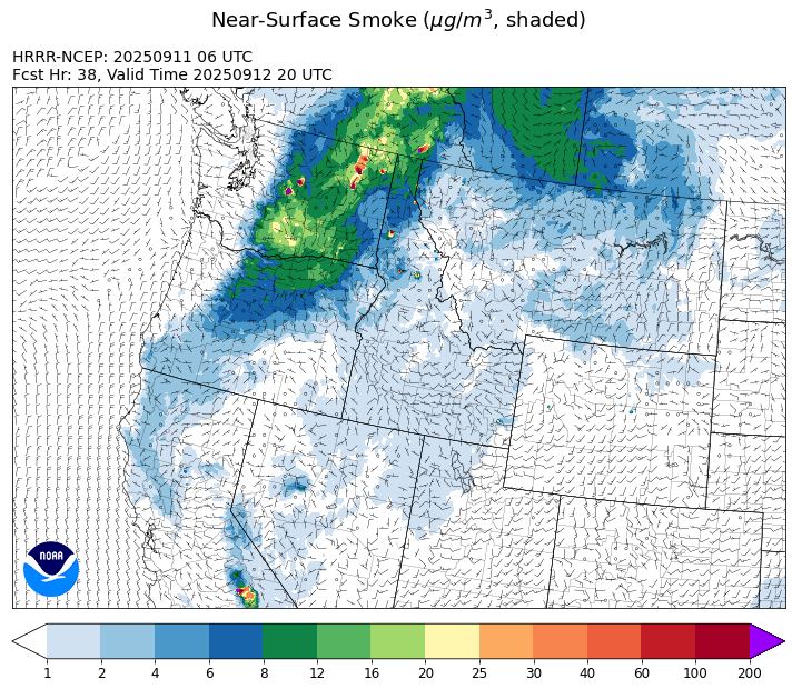
Source: HRRR-smoke
Forecast
An upper-level low will slowly move east across the Northern Rockies Thursday and Friday. It will generate scattered showers and storms. A few of the storms could produce strong outflow winds that could generate erratic fire behavior. The storms will tend to be less intense than they have been, but precipitation will be more widespread on Thursday compared to prior days. Higher humidity, cooler air, and precipitation will help to moderate fire behavior and reduce smoke production.
By this weekend, humidity levels will remain elevated thanks to the upper-level trough remaining in place over the state. A few isolated showers and storms are possible, but widespread precipitation is unlikely. There will be a brief break early Sunday before the next trough approaches from the west by Sunday evening.
Starting early next week, a strong upper-level low moves over the Northern Rockies. It will produce daily scattered showers and storms. The combination of higher humidity levels and precipitation should help to slow fire growth and limit smoke on regional wildfires. Stay tuned!
Conditions can change quickly as weather could stimulate active fires and the likelihood of new starts increases. Please keep track of concentrations at todaysair.mtdeq.us or the Fire and Smoke Map.
Thursday morning’s satellite image shows clouds covering much of the state thanks to an upper-level area of low pressure.

Source: NOAA
| Incident Name | State | Location | Acres | Containment |
|---|---|---|---|---|
| Mire | Idaho | Approximately 25 miles west of Powell Idaho and 35 miles northeast of Lowell Idaho | 1321 | 0% |
| Island Creek | Idaho | 14 Miles N of Elk City, ID | 14802 | 5% |
| East | Idaho | 8 miles northwest of Powell Idaho | 2114 | 0% |
| Green Rattle Complex | Idaho | NA | 458 | NA |
| Rattle Mountain Fire | Idaho | 13 miles North/Northeast of Clark Fork, ID | 115 | 0% |
| Green Mtn Fire | Idaho | 8 miles West/Southwest of Clark Fork, ID | 35 | 0% |
| White Pine | Idaho | 7 Miles NE of Harvard, ID near White Pine Campground and Trailhead | 938 | 10% |
| Twin | Idaho | 29 air miles northeast of Headquarters, ID in Twin Cabin Creek drainage, a tributary to Quartz Creek on the North Fork Ranger District. | 850 | 0% |
| Ulm Creek Fire | Idaho | 16 miles north of Prichard, ID and 10 miles south of Heron, MT. | 2713 | 10% |
| Rock Fire | Idaho | 5 miles southwest of Donnelly, ID | 2796 | 92% |
| Lightning Creek Fire | Idaho | 9 miles north of Clark Fork, ID | 2525 | 25% |
| Big Bear | Idaho | 59 Miles NE of McCall, Idaho - Frank Church-River of No Return Wilderness | 16249 | 70% |
| Rush | Idaho | 57 Miles NW of McCall, Idaho - Frank Church-River of No Return Wilderness | 7908 | 90% |
| Shingle | Idaho | NA | 100 | 55% |
| Elkhorn Fire | Idaho | 45 Miles E of Challis, ID | 1779 | 0% |
| Ransome Fire | Montana | 11 Miles northwest of Libby, MT | 701 | 31% |
| Isabella and Lost Girl Fires | Montana | NA | 770 | 0% |
| West Fork Fire | Montana | 23 Miles NW of West Yellowstone, MT, Custer Gallatin National Forest | 963 | 83% |
| Windy Rock Fire | Montana | 15 Miles NE of Drummond, MT | 6031 | 26% |
| Cloudrest | Montana | 15 Miles northwest of Virginia City, MT | 3148 | 54% |
| Timber Butte | Montana | 6 miles west of Dell, MT | 2245 | 70% |
| Sandbar 2 Fire | Montana | 15 miles east of Lincoln, Montana; north of Montana State Highway 279 and Flesher Pass | 243 | 75% |
| McAllister Fire | Montana | Madison County, 3 miles south of Norris, 3 miles north of Ennis Lake | 3560 | 95% |
| Gill Gulch Fire | Montana | 7 Miles south of Lincoln, MT | 34 | 75% |
| Black Rock Fire | Oregon | 13 miles west of Fossil, OR | 40684 | 59% |
| Marks Creek | Oregon | 18 miles east of Prineville, Oregon | 1718 | 72% |
| Bridge Fire | Oregon | Malheur National Forest, Blue Mountain Ranger District | 350 | 44% |
| Emigrant Fire | Oregon | 24 miles southeast of Oakridge, Oregon | 32294 | 10% |
| Kelsey Peak Fire | Oregon | 15 miles west of Glendale, Oregon | 1036 | 15% |
| Moon Complex | Oregon | 11 Miles NE of Agness, OR | 3504 | 4% |
| Foley Ridge Fire | Oregon | McKenzie River Highway | 245 | 0% |
| Flat Fire | Oregon | 4 Miles Northeast of Sisters, OR | 23346 | 81% |
| Crown Creek Fire | Washington | 1 Mile SE of Marble, WA | 14235 | 20% |
| Tacoma Creek Fire | Washington | 15 miles NW of Cusick, WA | 3686 | 0% |
| Katy Creek | Washington | 6 Miles NW of Kettle Falls, WA | 3573 | 5% |
| Lynx Mountain | Washington | 7 Miles NW of Inchelium, WA | 5033 | 6% |
| Rattlesnake | Washington | 2 miles West of Seven Bays, WA | 21338 | 50% |
| Sugar | Washington | 5 Miles NE of Conconully, WA | 96 | 75% |
| Wildcat Fire | Washington | 30 miles West of Naches, WA | 7893 | 8% |
| Pomas Fire | Washington | Approximately 36 miles northwest of Entiat, WA | 3533 | 0% |
| Martin | Washington | 45 Miles NW of Chelan, WA | 175 | 5% |
| Lower Sugarloaf Fire | Washington | 17 miles west of Entiat, WA | 13814 | 0% |
| Labor Mountain Fire | Washington | 10 miles North of Cle Elum, WA | 4000 | 0% |
| Bear Gulch Fire | Washington | 10 Miles Northwest of Hoodsport, WA | 10629 | 9% |
| Perry Fire | Washington | 16 miles NE of Newhalem, WA, west of Ross Lake | 1557 | 0% |
| Snow Peak | Washington | 19 miles W of Kettle Falls | 700 | 0% |
Tags: Smoke Forecast 2025