
Smoke Forecast for Wednesday, September 10, 2025 9:30 AM
Current Conditions
An area of low pressure will crawl slowly across the state, producing beneficial precipitation and helping to reduce smoke production on regional wildfires.
The Ulm Creek fire, burning just west of Trout Creek, Montana, is much less active than the prior week. It has grown to 2,713 acres and is 10% contained. The Knowles fire burning near Paradise, Montana remains active, and has burned 3,816 acres. The blaze is now 60% contained. The Devil Mountain and Windy Rock fires, burning 15 miles northeast of Drummond, were active again on Tuesday. The Devil Mountain fire has burned 1,932 acres and the Windy Rock has grown to 6,025 acres and is 21% contained. The Ransome fire, burning just north of Libby, remained active on Tuesday. It has grown to 701 acres and is 29% contained. The Timber Butte fire, burning just west of Dell, Montana, was less active on Tuesday. It has burned 2,245 acres and is 70% contained. There are several active wildfires burning in central and northern Idaho. The biggest of concern for Montana’s air quality are the East, Mire, Twin, Rhoda Creek, Big Bear, and Island Creek wildfires.
At 9:00 AM Wednesday, Columbia Falls, Frenchtown, Missoula, Helena, Lewistown, Cut Bank, Great Falls, Hamilton, Butte, Miles City, Billings, Glasgow, and Broadus’ air quality is Moderate.
By Thursday afternoon, the High-Resolution Rapid Refresh (HRRR) smoke model shows surface smoke covering much of the northern half of the state from regional wildfires.
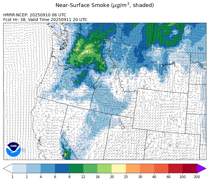
Source: HRRR-smoke
Forecast
A slow-moving area of low pressure will keep things unsettled across Montana through Friday. Most of the heaviest precipitation will fall in the afternoon and evening as daytime heating helps to destabilize the atmosphere. Afternoon transport winds will largely be out of the north Wednesday and Thursday, which should keep much of the smoke from Idaho wildfires out of the state. Gusty outflow winds near thunderstorms could lead to more active fire behavior if a storm is close enough to a wildfire.
By Thursday, the coverage and intensity of the precipitation should increase thanks to better moisture and instability. Some of the stronger storms could contain gusty winds, very heavy rain, and even some small hail. Overall, the combination of clouds, higher humidity, and cooler temperatures should moderate fire behavior and reduce smoke production.
Models continue to advertise another low moving into the Northern Rockies this weekend. It will keep scattered precipitation in the forecast along with seasonably cool temperatures. Longer range models are still hinting at yet another storm system moving into the state next week, providing additional precipitation. Stay tuned!
Conditions can change quickly as weather could stimulate active fires and the likelihood of new starts increases. Please keep track of concentrations at todaysair.mtdeq.us or the Fire and Smoke Map.
Wednesday morning’s satellite image reveals smoke covering much of the state from regional wildfires while an area of low-pressure spreads clouds and precipitation.

Source: NOAA
| Incident Name | State | Location | Acres | Containment |
|---|---|---|---|---|
| Rattle Mountain Fire | Idaho | 13 miles North/Northeast of Clark Fork, ID | 102 | 0% |
| Green Rattle Complex | Idaho | NA | 367 | NA |
| Green Mtn Fire | Idaho | 8 miles West/Southwest of Clark Fork, ID | 13 | 0% |
| Mire | Idaho | Approximately 25 miles west of Powell Idaho and 35 miles northeast of Lowell Idaho | 1321 | 0% |
| Island Creek | Idaho | 14 Miles N of Elk City, ID | 14802 | 5% |
| East | Idaho | 8 miles northwest of Powell Idaho | 2114 | 0% |
| Rock Fire | Idaho | 5 miles southwest of Donnelly, ID | 2796 | 92% |
| White Pine | Idaho | 7 Miles NE of Harvard, ID near White Pine Campground and Trailhead | 797 | 10% |
| Ulm Creek Fire | Idaho | 16 miles north of Prichard, ID and 10 miles south of Heron, MT. | 2713 | 10% |
| Lightning Creek Fire | Idaho | 9 miles north of Clark Fork, ID | 2525 | 25% |
| Twin | Idaho | 29 air miles northeast of Headquarters, ID in Twin Cabin Creek drainage, a tributary to Quartz Creek on the North Fork Ranger District. | 761 | 0% |
| Big Bear | Idaho | 59 Miles NE of McCall, Idaho - Frank Church-River of No Return Wilderness | 16249 | 70% |
| Rush | Idaho | 57 Miles NW of McCall, Idaho - Frank Church-River of No Return Wilderness | 7908 | 90% |
| Shingle | Idaho | NA | 100 | 55% |
| Elkhorn Fire | Idaho | 45 Miles E of Challis, ID | 1779 | 0% |
| Windy Rock Fire | Montana | 15 Miles NE of Drummond, MT | 6025 | 21% |
| West Fork Fire | Montana | 23 Miles NW of West Yellowstone, MT, Custer Gallatin National Forest | 963 | 83% |
| Cloudrest | Montana | 15 Miles northwest of Virginia City, MT | 3148 | 54% |
| Timber Butte | Montana | 6 miles west of Dell, MT | 2245 | 70% |
| Isabella & Lost Girl Fires | Montana | NA | 671 | 0% |
| Ransome Fire | Montana | 11 Miles northwest of Libby, MT | 701 | 29% |
| Knowles Fire | Montana | 11 Miles E of Plains, MT | 3816 | 60% |
| Sandbar 2 Fire | Montana | 15 miles east of Lincoln, Montana; north of Montana State Highway 279 and Flesher Pass | 243 | 75% |
| McAllister Fire | Montana | Madison County, 3 miles south of Norris, 3 miles north of Ennis Lake | 3560 | 95% |
| Gill Gulch Fire | Montana | 7 Miles south of Lincoln, MT | 34 | 75% |
| Black Rock Fire | Oregon | 13 miles west of Fossil, OR | 40684 | 20% |
| Emigrant Fire | Oregon | 24 miles southeast of Oakridge, Oregon | 32294 | 1% |
| Kelsey Peak Fire | Oregon | 15 miles west of Glendale, Oregon | 984 | 12% |
| Moon Complex | Oregon | 11 Miles NE of Agness, OR | 3238 | 0% |
| Bridge Fire | Oregon | Malheur National Forest, Blue Mountain Ranger District | 350 | 29% |
| Marks Creek | Oregon | 18 miles east of Prineville, Oregon | 1718 | 27% |
| Foley Ridge Fire | Oregon | McKenzie River Highway | 800 | 0% |
| Flat Fire | Oregon | 4 Miles Northeast of Sisters, OR | 23346 | 81% |
| Katy Creek | Washington | 6 Miles NW of Kettle Falls, WA | 3467 | 5% |
| Tacoma Creek Fire | Washington | 15 miles NW of Cusick, WA | 3686 | 0% |
| Wildcat Fire | Washington | 30 miles West of Naches, WA | 7893 | 8% |
| Crown Creek Fire | Washington | 1 Mile SE of Marble, WA | 14221 | 15% |
| Lynx Mountain | Washington | 7 Miles NW of Inchelium, WA | 4521 | 5% |
| Rattlesnake | Washington | 2 miles West of Seven Bays, WA | 19947 | 33% |
| Martin | Washington | 45 Miles NW of Chelan, WA | 174 | 5% |
| Bear Gulch Fire | Washington | 10 Miles Northwest of Hoodsport, WA | 10629 | 9% |
| Perry Fire | Washington | 16 miles NE of Newhalem, WA, west of Ross Lake | 1557 | 0% |
| Labor Mountain Fire | Washington | 10 miles North of Cle Elum, WA | 3063 | 0% |
| Lower Sugarloaf Fire | Washington | 17 miles west of Entiat, WA | 12685 | 0% |
| Sugar | Washington | 5 Miles NE of Conconully, WA | 114 | 0% |
| Snow Peak | Washington | 19 miles W of Kettle Falls | 700 | 0% |
| Pomas Fire | Washington | Approximately 36 miles northwest of Entiat, WA | 3533 | 0% |
Tags: Smoke Forecast 2025