
Smoke Forecast for Sunday, August 9, 2026 9:30 AM
Current Conditions
Montana Department of Environmental Quality has issued an air quality alert for Beaverhead, Deer Lodge, Flathead, Granite, Jefferson, Lake, Lewis and Clark, Lincoln, Madison, Mineral, Missoula, Powell, Ravalli, Sanders, Silver Bow counties in effect until 9AM on 08/10/2026.
An Air Resource Advisor has been assigned to the smoke event across central and western Montana due to local and regional wildfires.
Saturday afternoon, the most active Montana wildfires continued burning in the Pioneer and Sapphire Mountains. The Bobcat Lakes Fire has burned more than 7,000 acres. The Sand Creek Fire has grown quickly over the last 48-hours, burning over 11,000 acres. The Moose and Black Bear fires, burning in the Sapphire Mountains between Georgetown Lake and the Bitterroot Valley, exhibited active fire behavior again on Saturday. The Moose Fire has burned nearly 4,300 acres. The Black Bear Fire has burned more than 1,400 acres. These fires will send smoke to downstream communities like Helena through at least Monday.
As of 8 AM, particulate levels in Columbia Falls are Very Unhealthy. Particulate levels in Dillon, Libby and Thompson Falls are Unhealthy. Particulate levels in Billings, Butte, Hamilton, Lewistown and Sleeping Giant are Unhealthy for Sensitive Groups. Particulate levels in Cut Bank, Frenchtown, Great Falls, Havre, Helena, Malta and Missoula are Moderate.
By Monday afternoon, the Rapid Refresh Forecast System (RRFS) smoke model shows areas of heavy smoke covering parts of the state.
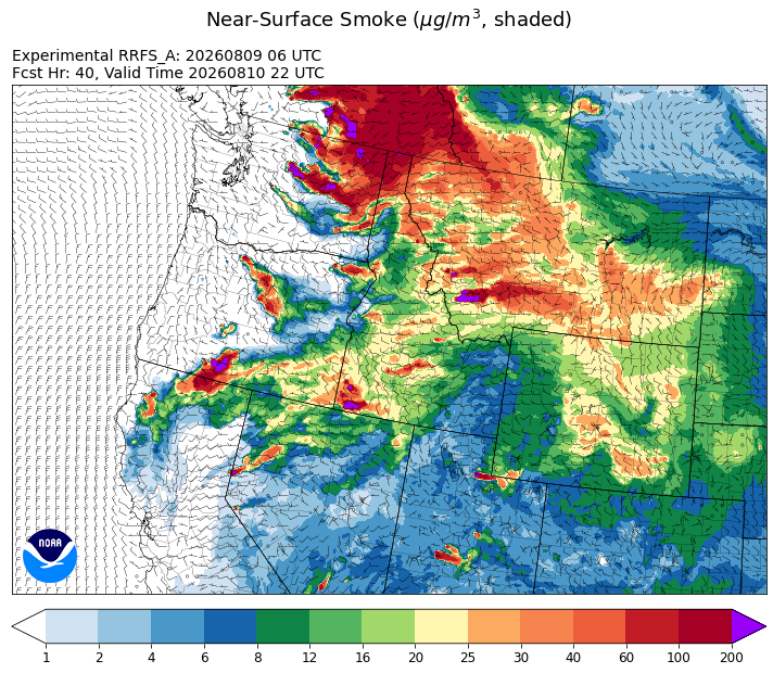
Source: HRRR-smoke
Forecast
Montana will remain under the influence of a sprawling area of high pressure centered over the Great Basin through Monday. This set-up will produce hot, dry, and breezy conditions, with elevated fire weather. Established and emerging wildfires will spread quickly in this regime. Smoke from regional wildfires will continue to bring air quality impacts, particularly to the western third of the state (see Air Quality Alert).
A trough moves into Montana between Wednesday and Thursday. This will provide some beneficial precipitation for the region. The best chances for a soaking rainfall are across the northern half of the state. The trough will begin to ease regional wildfire behavior and limit smoke production across the state.
A more active weather pattern sets up over the Northern Rockies for next weekend. This combined with a southwesterly flow will push smoke from regional wildfires across the state. The pattern will also provide daily rounds of showers and thunderstorms. Stay tuned!
Conditions can change quickly as weather could stimulate active fires and the likelihood of new starts increases. Please keep track of concentrations at todaysair.mtdeq.us or the Fire and Smoke Map.
Smoke remains visible across much of the state early Sunday from regional wildfires.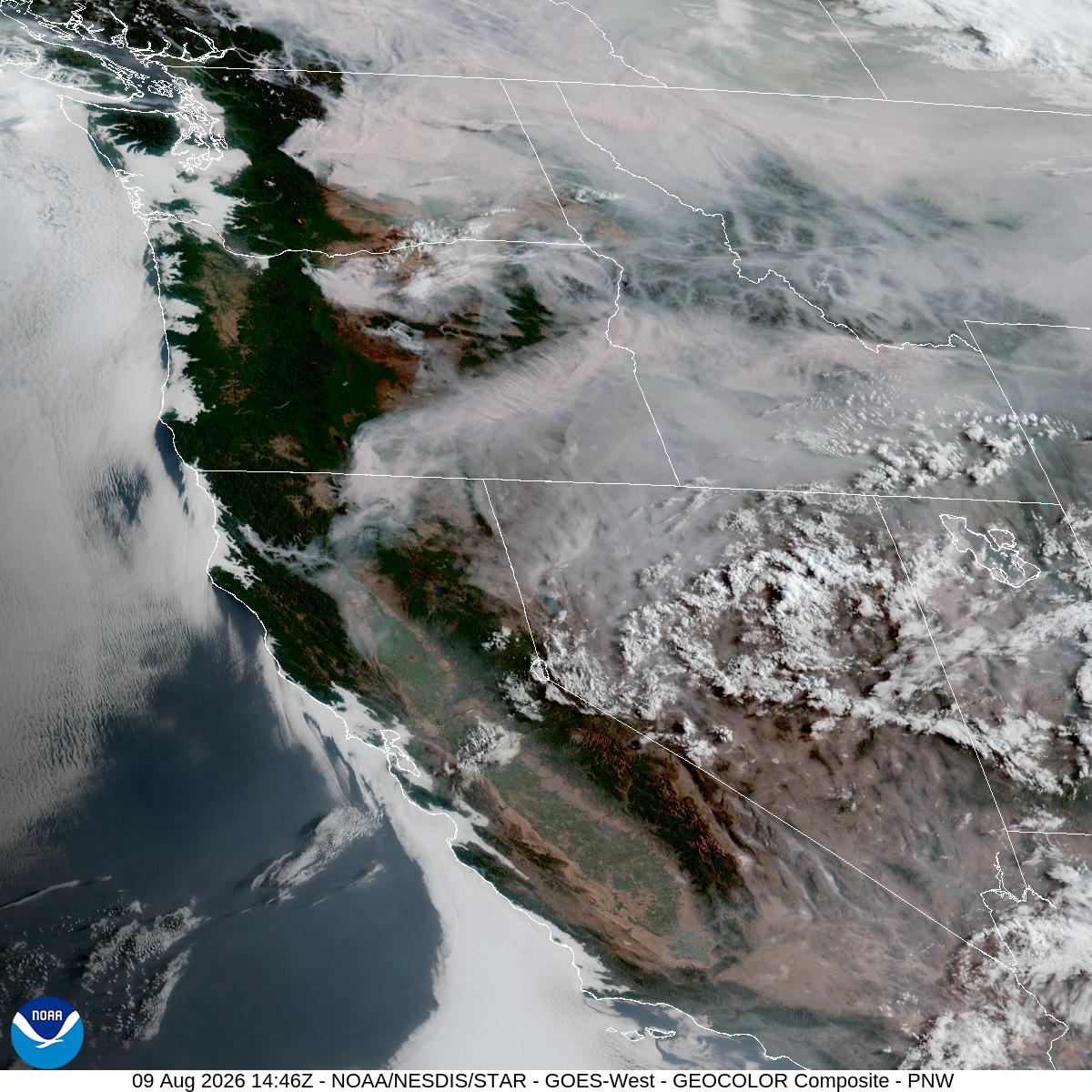
Source: NOAA
| Incident Name | State | Location | Acres | Containment |
|---|---|---|---|---|
| Lake | Idaho | 4 Miles SW of Secesh, ID | 164 | 0% |
| Cascade | Idaho | 22 miles East of Lowell, Idaho | 3300 | NA |
| Upper Smith Fire | Idaho | Six miles West of Porthill, Idaho | 3222 | 32% |
| Porcupine Fire | Idaho | NA | 75 | 0% |
| Tartar | Idaho | 21 Miles NW of Weiser, ID | 158022 | 82% |
| Moose Mountain | Idaho | Approximately 4 miles north of Kelly Forks Camp Ground | 646 | 0% |
| Chimney Fire | Idaho | 9 miles northwest of Fairfield, ID | 6521 | 80% |
| Claremont Fire | Idaho | 1 mile NE of Boise, Idaho | 6606 | 90% |
| Duncan | Idaho | 50 Miles SW of Mountain Home, ID | 16362 | 70% |
| Double Springs Fire | Idaho | 31 miles Northwest of Mackay , ID | 1547 | 5% |
| Moose Fire | Montana | 24 miles southwest of Philipsburg | 4314 | 0% |
| Skillet Fire | Montana | 15 miles west of Olney, MT | 3298 | 11% |
| Ant Park | Montana | NA | NA | NA |
| Sand Creek | Montana | 7.5 miles southeast of Wisdom, Montana | 8890 | 1% |
| Bobcat Lakes | Montana | 12 miles east of Wisdom | 5514 | 0% |
| Silvertip Fire | Montana | NA | 6221 | NA |
| Black Bear Fire | Montana | 15 Miles E of Hamilton, MT | 225 | 0% |
| North Fork Fire | Montana | 10 miles southwest of Hamilton, MT, north of North Fork Lost Horse Creek | 118 | 20% |
| Butterfly Fire | Montana | 12 miles East of Hamilton, MT | 67 | 10% |
| Grasshopper | Oregon | 3 miles North of Sportmans Park, OR | 57087 | 23% |
| Wrights Spring | Oregon | 2 Miles W of Sprague River OR | 33970 | 0% |
| Fox Fire | Oregon | 12 Miles NE of Huntington, OR | 79003 | 63% |
| Bald Mountain | Oregon | 50 Miles SE of Burns, OR | 76160 | 78% |
| Jackass Butte | Oregon | 40 Miles S of Burns, OR | 24724 | 92% |
| Coleman Creek | Oregon | ~1 mile southeast of Juntura | 308721 | 89% |
| Second Flat | Oregon | Six miles NE of Riley, OR | 105501 | 86% |
| Big Grass Fire | Oregon | 25 Miles CW of Jordan Valley, OR | 513437 | 39% |
| Rowe Creek Complex | Oregon | 10 Miles S of Fossil, OR | 367847 | 79% |
| Castle | Oregon | 23 Miles NE of Tiller, OR | 3612 | 67% |
| Horse Ridge Fire | Oregon | 25 Miles East of Pendleton, OR | 860 | 98% |
| Paradise Fire | Oregon | 15 miles south of Pendleton Oregon | 2927 | 0% |
| Hagen Fire | Oregon | 26 Miles East of Pendleton, OR | 42699 | 11% |
| Henry Fire | Oregon | 5 Miles S of PAULINA GUARD STATION, OR | 29850 | 97% |
| Coyote Fire | Oregon | 5 miles south of Post, OR | 17488 | 89% |
| Shingle Fire | Oregon | 14 Miles SE of Mitchell, OR | 73092 | 74% |
| Burnt Creek Fire | Oregon | 23 Miles N of Enterprise, OR | 4169 | 87% |
| Salmon Fire | Oregon | 34 Miles SW of Baker City, OR | 1433 | 88% |
| Powder River Fire | Oregon | 4 Miles SW of RICHLAND, OR | 21088 | 96% |
| Bench | Oregon | 4 miles south of Warm Springs, OR | 67071 | 86% |
| Akawa Butte Fire | Oregon | 13 Miles NE of Sisters, OR | 27491 | 99% |
| Hat Fire | Oregon | 40 Miles East of Burns, OR | 44122 | 99% |
| Bologna Fire | Oregon | 7 miles northeast of Kimberly, OR | 2425 | 96% |
| Hay Creek Complex | Oregon | Gilliam, Sherman and Wasco counties, Oregon | 200292 | 97% |
| Anthony Fire | Oregon | 34 miles north of Baker City, OR | 2585 | 89% |
| Stubble | Oregon | 15 Miles SW of Lawen, OR | 15673 | 87% |
| Crater | Oregon | 35 Miles S of Burns, OR | 745 | 93% |
| Egypt Fire | Oregon | 12 Miles N of Riley, OR | 4595 | 68% |
| North Cayuse Fire | Oregon | 15 miles east of Pendleton, OR. | 4887 | 91% |
| Ptarmigan Fire | Washington | 25 Miles NW of Mazama, WA | 21385 | 0% |
| Bradeen Hill Fire - | Washington | 17 Miles SW of Colville, WA | 4424 | 76% |
| Hudspeth Fire | Washington | 3 miles northeast of Hunters, Washington | 5850 | 42% |
| Kaiser Canyon | Washington | 1 mile S of Nespelem, WA | 138268 | 62% |
| Border 2 Fire | Washington | 20 Miles NE of Marblemount, WA | 8866 | 0% |
| Sinlahekin Fire | Washington | 12 Miles W of Tonasket, WA | 137611 | 34% |
| Mitre Rock Fire | Washington | 19 miles northwest of Davenport, WA | 4460 | 93% |
| Modrite Fire | Washington | 17 Miles SW of Inchelium, WA | 56860 | 57% |
| Spokane Area Fires | Washington | Spokane County, Washington | 10002 | NA |
| Little Giant Fire | Washington | 30 miles NW of Leavenworth, WA | 97539 | 2% |
| High Lava Fire | Washington | 11 Miles NW of Stabler, WA | 878 | 0% |
| Three Queens | Washington | 6 Miles E of Snoqualmie Pass, WA | 881 | 0% |
| Luna Fire | Washington | 10 Miles North of Newhalem, WA | 3583 | 0% |
| Skyo Fire | Washington | 3 Miles SW of Packwood, WA | 254 | 83% |
| Mount Tom Creek Fire | Washington | Olympic National Park | 69 | 75% |
| Chelan Hills | Washington | 1 Mile N of Orando | 9735 | 75% |
Tags: smoke forecast