
Smoke Forecast for Friday, August 29, 2025 9:30 AM
Current Conditions
An Air Resource Advisor has been assigned to the Bivens Creek and Cloudrest fires burning near Twin Bridges in southwest Montana.
Recent precipitation has moderated fire behavior on many wildfires over Montana and central Idaho, helping to reduce smoke production.
The Knowles fire burning near Paradise, Montana, has burned 3,822 acres. Recent precipitation has helped firefighting efforts, and the blaze is now 47% contained. Firefighters have begun making progress on the Bivens Creek and Cloudrest, burning in the Tobacco Root Mountains. The Bivens Creek fire is now 53% contained, and the Cloudrest fire is 20% contained. The West Fork fire, burning just north of Hebgen Lake, was less active on Thursday. The fire has burned 853 acres and is now 40% contained. The Windy Rock fire, burning 15 miles northeast of Drummond, was less active on Thursday but it continues to slowly grow. It has burned 3,968 acres and is 0% contained. The Ransome fire, burning just north of Libby, was less active on Thursday thanks to cooler air and precipitation. It has grown to 538 acres and is 0% contained. The Island Creek fire, burning in central Idaho, was less active on Thursday. It has grown to 11,591 acres and is only 5% contained. An incident meteorologist was recently ordered for this fire, highlighting the ongoing concern for this blaze.
At 9:00 AM Friday, Thompson Falls, Hamilton, and Great Falls’ air quality is Moderate.
By Saturday evening, the High-Resolution Rapid Refresh (HRRR) smoke model shows a light northwesterly flow pushing smoke from regional wildfires into the western third of the state.
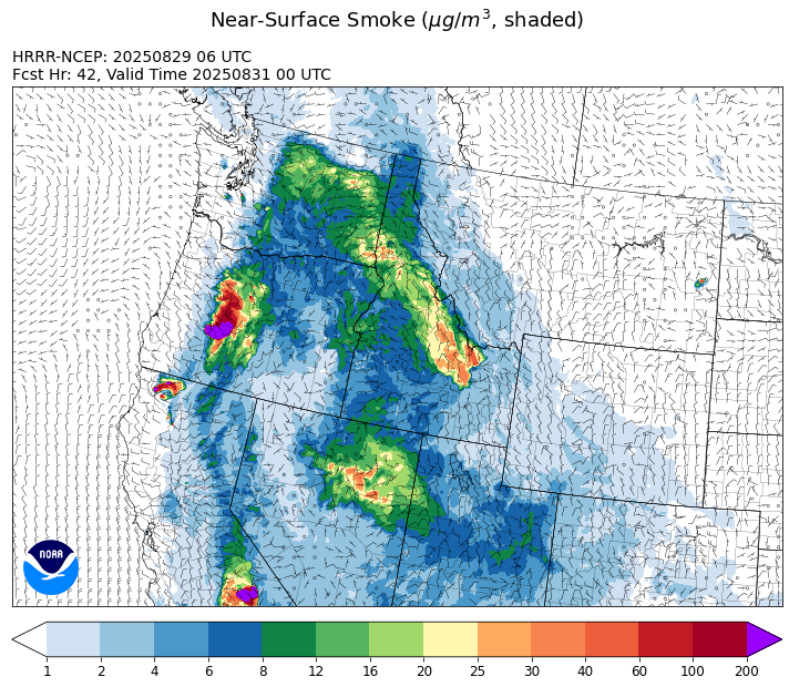
Source: HRRR-smoke
Forecast
An exiting area of low pressure will be the focus for a few showers and thunderstorms on Friday. Most of the heaviest precipitation will impact areas north of I-90 to end the week. Recent precipitation has helped to moderate fire behavior and limit smoke production on many regional wildfires. Much of southwest Montana and central Idaho picked up at least a half an inch of rain between Thursday and early Friday. A light westerly flow will send some smoke into communities on the east sides of Montana wildfires.
Warmer air and lower relative humidities should lead to more active wildfire behavior across the state by this weekend. High pressure will build across the area, bringing an end to the cool and showery weather pattern. Afternoon highs will approach 90 degrees over most valleys by Sunday.
The warmer and drier weather pattern is expected to persist over the Northern Rockies into next week. Montana will be on the eastern fringes of a strong ridge of high pressure parked over the Pacific Northwest. This will keep temperatures 10-15 degrees warmer than normal. A weak Canadian cool front arrives between Tuesday and Wednesday. It will be accompanied by some surface smoke from Canadian wildfires. Stay tuned!
Conditions can change quickly as weather could stimulate active fires and the likelihood of new starts increases. Please keep track of concentrations at todaysair.mtdeq.us or the Fire and Smoke Map.
Friday morning’s satellite image shows clouds along and ahead of a departing area of low pressure. Some smoke is visible over the western edges of the state.
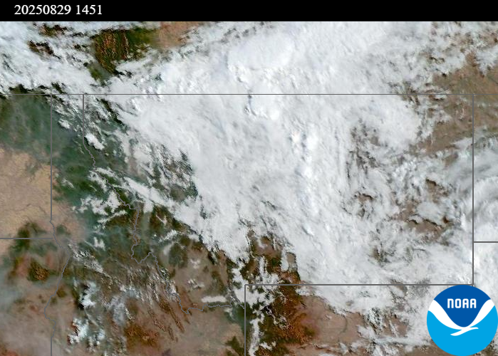
Source: NOAA
| Incident Name | State | Location | Acres | Containment |
|---|---|---|---|---|
| Rock Fire | Idaho | 5 miles southwest of Donnelly, ID | 2795 | 63% |
| Sunset Fire | Idaho | 26 Miles N of Coeur d'Alene, ID | 3230 | 75% |
| East | Idaho | 8 miles northwest of Powell Idaho | 636 | 1% |
| Mire | Idaho | Approximately 25 miles west of Powell Idaho | 744 | 0% |
| Big Bear | Idaho | 59 Miles NE of McCall, Idaho - Frank Church-River of No Return Wilderness | 15517 | 70% |
| Rush | Idaho | 57 Miles NW of McCall, Idaho - Frank Church-River of No Return Wilderness | 7908 | 90% |
| Island Creek | Idaho | Near Sob Point on the Moose Creek Ranger District. | 11591 | 5% |
| Twin | Idaho | 29 air miles northeast of Headquarters, ID in Twin Cabin Creek drainage, a tributary to Quartz Creek on the North Fork Ranger District. | 272 | 0% |
| Lightning Creek Fire | Idaho | 9 miles north of Clark Fork, ID | 2525 | 25% |
| Shingle | Idaho | NA | 100 | 55% |
| Cedar Fire | Idaho | approximately 4 miles northeast of Clyde | 898 | 90% |
| Elkhorn Fire | Idaho | 45 Miles E of Challis, ID | 1213 | 0% |
| Windy Rock Fire | Montana | 15 Miles NE of Drummond, MT | 3968 | 0% |
| Knowles Fire | Montana | 11 Miles E of Plains, MT | 3822 | 47% |
| Bivens Creek | Montana | 15 Miles North of Virginia City, MT | 2233 | 53% |
| Cloudrest | Montana | 15 Miles northwest of Virginia City, MT | 3476 | 20% |
| Corral Creek Fire | Montana | 4.5 miles south of Huson, MT | 356 | 84% |
| Ransome Fire | Montana | 11 Miles northwest of Libby, MT | 538 | 0% |
| Sandbar 2 Fire | Montana | 15 miles east of Lincoln, Montana; north of Montana State Highway 279 and Flesher Pass | 243 | 75% |
| West Fork Fire | Montana | 23 Miles NW of West Yellowstone, MT, Custer Gallatin National Forest | 853 | 40% |
| McAllister Fire | Montana | Madison County, 3 miles south of Norris, 3 miles north of Ennis Lake | 3560 | 95% |
| Gill Gulch Fire | Montana | 7 Miles south of Lincoln, MT | 34 | 75% |
| Flat Fire | Oregon | 4 Miles Northeast of Sisters, OR | 23380 | 7% |
| Emigrant Fire | Oregon | 3 miles southwest of Indigo Springs Campground | 9054 | 0% |
| Grande Fire | Washington | 12 miles north of Colville | 22 | 0% |
| Bear Gulch Fire | Washington | 10 Miles Northwest of Hoodsport, WA | 8960 | 13% |
| Pomas Fire | Washington | Approximately 36 miles northwest of Entiat, WA | 3533 | 0% |
Tags: Smoke Forecast 2025