
Smoke Forecast for Thursday, August 28, 2025 12:00 PM
Current Conditions
An Air Resource Advisor has been assigned to the Bivens Creek and Cloudrest fires burning near Twin Bridges in southwest Montana.
Cooler air, higher humidity, and precipitation have helped to moderate fire behavior on many regional wildfires.
The Knowles fire burning near Paradise, Montana, has burned 3,822 acres. Recent precipitation has helped firefighting efforts, and the blaze is now 47% contained. Firefighters have begun making progress on the Bivens Creek and Cloudrest, burning in the Tobacco Root Mountains. The Bivens Creek fire is now 34% contained, and the Cloudrest fire is 12% contained. The West Fork fire burning just north of Hebgen Lake was less active on Thursday. The fire has burned 853 acres and is now 40% contained. The Windy Rock fire, burning 15 miles northeast of Drummond, was less active on Thursday but it continues to slowly grow. It has burned 3,895 acres and is 0% contained. The Ransome fire, burning just north of Libby, was less active on Thursday thanks to clouds and cooler air. It has grown to 487 acres and is 0% contained. The Island Creek fire, burning in central Idaho, was less active on Thursday. It has grown to 11,591 acres and is only 5% contained.
At 12:00 PM Thursday, Havre, Sidney, Columbia Falls, and Great Falls’ air quality is Moderate.
By Friday evening, the High-Resolution Rapid Refresh (HRRR) smoke model shows a light northwesterly flow pushing smoke from regional wildfires into parts of the state.
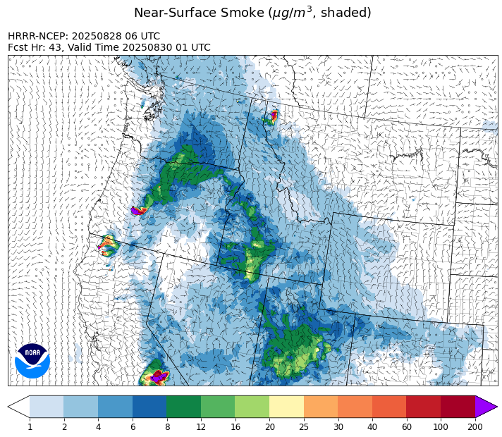
Source: HRRR-smoke
Forecast
Clouds, cooler temperatures, and precipitation have helped to moderate fire behavior and reduce smoke production on many regional wildfires. Smoke models continue to highlight an overall decrease in surface smoke over the next 48-hours. An anomalously moist airmass continues to lift slowly north across the state on Thursday, enhancing precipitation totals in many places.
The storm system shifts slowly north on Friday. A few scattered storms are possible in the afternoon, but the bulk of the precipitation will impact communities north of I-90. Transport winds will remain out of the northwest and that will bring some light surface smoke into the western third of the state from Idaho wildfires.
The monsoonal moisture exits the region over the weekend. Expect warmer and less humid air to return to the state. This will lead to more active fire behavior and an increase in smoke production. Recent thunderstorms combined with dry fuels could result in new fire starts over the weekend, particularly in southwest Montana where fuel moistures are more receptive.
Conditions can change quickly as weather could stimulate active fires and the likelihood of new starts increases. Please keep track of concentrations at todaysair.mtdeq.us or the Fire and Smoke Map.
Thursday morning’s satellite image shows monsoonal moisture spreading clouds and precipitation into the western two thirds of the state.
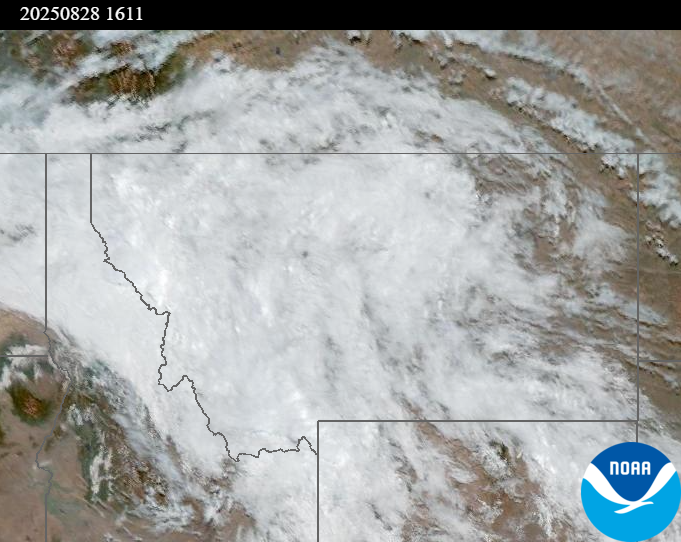
Source: NOAA
| Incident Name | State | Location | Acres | Containment |
|---|---|---|---|---|
| Rock Fire | Idaho | 5 miles southwest of Donnelly, ID | 2792 | 42% |
| Sunset Fire | Idaho | 26 Miles N of Coeur d'Alene, ID | 3230 | 66% |
| East | Idaho | 8 miles northwest of Powell Idaho | 636 | 1% |
| Mire | Idaho | Approximately 25 miles west of Powell Idaho | 744 | 0% |
| Island Creek | Idaho | Near Sob Point on the Moose Creek Ranger District. | 11591 | 5% |
| Twin | Idaho | 29 air miles northeast of Headquarters, ID in Twin Cabin Creek drainage, a tributary to Quartz Creek on the North Fork Ranger District. | 272 | 0% |
| Lightning Creek Fire | Idaho | 9 miles north of Clark Fork, ID | 2525 | 25% |
| Rush | Idaho | 57 Miles NW of McCall, Idaho - Frank Church-River of No Return Wilderness | 7908 | 90% |
| Big Bear | Idaho | 59 Miles NE of McCall, Idaho - Frank Church-River of No Return Wilderness | 15517 | 70% |
| Shingle | Idaho | NA | 100 | 55% |
| Cedar Fire | Idaho | approximately 4 miles northeast of Clyde | 898 | 90% |
| Elkhorn Fire | Idaho | 45 Miles E of Challis, ID | 1213 | 0% |
| Knowles Fire | Montana | 11 Miles E of Plains, MT | 3822 | 47% |
| Windy Rock Fire | Montana | 15 Miles NE of Drummond, MT | 3895 | 0% |
| Sandbar 2 Fire | Montana | 15 miles east of Lincoln, Montana; north of Montana State Highway 279 and Flesher Pass | 243 | 75% |
| Cloudrest | Montana | 15 Miles northwest of Virginia City, MT | 3476 | 12% |
| Bivens Creek | Montana | 15 Miles North of Virginia City, MT | 2233 | 34% |
| Ransome Fire | Montana | 11 Miles northwest of Libby, MT | 487 | 0% |
| Corral Creek Fire | Montana | 4.5 miles south of Huson, MT | 364 | 31% |
| McAllister Fire | Montana | Madison County, 3 miles south of Norris, 3 miles north of Ennis Lake | 3560 | 95% |
| West Fork Fire | Montana | 23 Miles NW of West Yellowstone, MT, Custer Gallatin National Forest | 853 | 40% |
| Gill Gulch Fire | Montana | 7 Miles south of Lincoln, MT | 34 | 75% |
| Emigrant Fire | Oregon | 3 miles southwest of Indigo Springs Campground | 7764 | 0% |
| Flat Fire | Oregon | 4 Miles Northeast of Sisters, OR | 23261 | 7% |
| Grande Fire | Washington | 12 miles north of Colville | 25 | 0% |
| Bear Gulch Fire | Washington | 10 Miles Northwest of Hoodsport, WA | 8949 | 13% |
| Pomas Fire | Washington | Approximately 36 miles northwest of Entiat, WA | 3533 | 0% |
Tags: Smoke Forecast 2025