
Smoke Forecast for Wednesday, August 27, 2025 2:00 PM
Current Conditions
An Air Resource Advisor has been assigned to the Bivens Creek and Cloudrest fires burning near Twin Bridges in southwest Montana.
Clouds, cooler temperatures, and precipitation have helped to moderate fire behavior and limit smoke production on regional wildfires.
The Knowles fire burning near Paradise, Montana, was less active on Wednesday. It has burned 3,822 acres and is 26% contained. Two wildfires continue to burn in the Tobacco Root Mountains. Firefighters have begun making progress on the Bivens Creek and Cloudrest, burning in the Tobacco Root Mountains. The Bivens Creek fire is now 34% contained, and the Cloudrest fire is 12% contained. The West Fork fire burning just north of Hebgen Lake was less active on Wednesday. The fire has burned 853 acres and is now 40% contained. The Windy Rock fire, burning 15 miles northeast of Drummond, was less active on Wednesday. It is up to 3,631 acres and is 0% contained. The Ransome fire, burning just north of Libby, was less active on Wednesday thanks to clouds and cooler air. It has grown to 473 acres and is 0% contained. The Island Creek fire, burning in central Idaho, remains active. It has grown to 11,591 acres and is only 5% contained. A light easterly flow should keep much of the smoke west of Montana.
At 2:00 PM Wednesday, Frenchtown, Seeley Lake, Libby, Thompson Falls, Hamilton, Dillon, and Great Falls’ air quality is Moderate.
By Thursday evening, the High-Resolution Rapid Refresh (HRRR) smoke model shows a light westerly flow pushing smoke from regional wildfires into parts of the state.
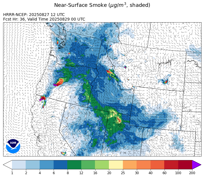
Source: HRRR-smoke
Forecast
Anomalously moist air continues to stream north into the Northern Rockies. This monsoonal moisture combined with afternoon heating should be enough to kick off scattered thunderstorms. The main threats from these storms will be from heavy rainfall and frequent lightning. The combination of dry fuels and lightning could be enough to trigger new fire starts, particularly over southwest Montana where fuel moistures are particularly dry. A light easterly flow should keep the bulk of the smoke from the central Idaho fires out of the Bitterroot Valley on Wednesday.
Scattered showers and storms will linger into Thursday. The combination of clouds, cooler air, and precipitation should help keep fire behavior in check and reduce smoke production on regional wildfires. Precipitation shifts a bit further north on Thursday, with flash flooding and debris flows possible on recent burn scars.
Temperatures should quickly rebound by this weekend as a transient ridge of high pressure builds. Highs in many western Montana valleys will climb into the 90s. Warmer air and gusty afternoon winds will produce more active fire behavior on regional wildfires. It could also lead to additional fire starts from Wednesday and Thursday’s thunderstorms. Stay tuned!
Conditions can change quickly as weather could stimulate active fires and the likelihood of new starts increases. Please keep track of concentrations at todaysair.mtdeq.us or the Fire and Smoke Map.
Wednesday afternoon’s satellite image shows monsoonal moisture spreading clouds and precipitation into the western two thirds of the state.
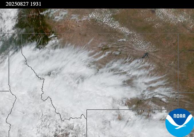
Source: NOAA
| Incident Name | State | Location | Acres | Containment |
|---|---|---|---|---|
| East | Idaho | 8 miles northwest of Powell Idaho | 636 | 0% |
| Mire | Idaho | Approximately 22 miles West/NW of Powell Idaho | 788 | 0% |
| Sunset Fire | Idaho | 26 Miles N of Coeur d'Alene, ID | 3230 | 52% |
| Rock Fire | Idaho | 5 miles southwest of Donnelly, ID | 2792 | 42% |
| Island Creek | Idaho | Near Sob Point on the Moose Creek Ranger District. | 11591 | 5% |
| Lightning Creek Fire | Idaho | 9 miles north of Clark Fork, ID | 2525 | 25% |
| Twin | Idaho | 29 air miles northeast of Headquarters, ID in Twin Cabin Creek drainage, a tributary to Quartz Creek on the North Fork Ranger District. | 272 | 0% |
| Rush | Idaho | 57 Miles NW of McCall, Idaho - Frank Church-River of No Return Wilderness | 7908 | 90% |
| Big Bear | Idaho | 59 Miles NE of McCall, Idaho - Frank Church-River of No Return Wilderness | 15517 | 70% |
| Shingle | Idaho | NA | 100 | 55% |
| Cedar Fire | Idaho | approximately 4 miles northeast of Clyde | 898 | 90% |
| Elkhorn Fire | Idaho | 45 Miles E of Challis, ID | 1213 | 0% |
| Windy Rock Fire | Montana | 15 Miles NE of Drummond, MT | 3631 | 0% |
| Sandbar 2 Fire | Montana | 15 miles east of Lincoln, Montana; north of Montana State Highway 279 and Flesher Pass | 243 | 45% |
| Cloudrest | Montana | 15 Miles northwest of Virginia City, MT | 3476 | 12% |
| Bivens Creek | Montana | 15 Miles North of Virginia City, MT | 2233 | 34% |
| West Fork Fire | Montana | 23 Miles NW of West Yellowstone, MT, Custer Gallatin National Forest | 853 | 40% |
| Knowles Fire | Montana | 11 Miles E of Plains, MT | 3822 | 26% |
| Corral Creek Fire | Montana | 4.5 miles south of Huson, MT | 368 | 15% |
| Ransome Fire | Montana | 11 Miles northwest of Libby, MT | 473 | 0% |
| Gill Gulch Fire | Montana | 7 Miles south of Lincoln, MT | 34 | 75% |
| McAllister Fire | Montana | Madison County, 3 miles south of Norris, 3 miles north of Ennis Lake | 3560 | 85% |
| Emigrant Fire | Oregon | 3 miles southwest of Indigo Springs Campground | 7400 | 0% |
| Flat Fire | Oregon | 4 Miles Northeast of Sisters, OR | 23261 | 7% |
| Bear Gulch Fire | Washington | 10 Miles Northwest of Hoodsport, WA | 8949 | 13% |
| Pomas Fire | Washington | Approximately 36 miles northwest of Entiat, WA | 3533 | 0% |
Tags: Smoke Forecast 2025