
Smoke Forecast for Tuesday, August 26, 2025 9:30 AM
Current Conditions
An Air Resource Advisor has been assigned to the Bivens Creek and Cloudrest fires burning near Twin Bridges in southwest Montana.
Increasing clouds and higher humidity on Tuesday should help to moderate fire behavior and reduce smoke production on regional wildfires.
The Knowles fire burning near Paradise, Montana, remains active. It has burned 3,638 acres and is 16% contained. Two wildfires burning in the Tobacco Root Mountains continue to expand. Expect some downstream impacts in the coming days from the Bivens Creek and Cloudrest fires which are both 0% contained. The West Fork fire burning just north of Hebgen Lake was active again on Monday. The fire has burned 619 acres and is now 33% contained. The Windy Rock fire, burning 15 miles northeast of Drummond, remains active. It is up to 3,426 acres and is 0% contained. The Ransome fire, burning just north of Libby, exhibited active fire behavior again on Monday. It has grown to 441 acres and is 0% contained. The Island Creek fire, burning in central Idaho, remains active. It has grown to 10,743 acres and is only 5% contained. A light easterly flow should keep much of the smoke west of Montana.
At 9:00 AM Tuesday, Frenchtown, Butte, Libby, Thompson Falls, Hamilton, Dillon, and Great Falls’ air quality is Moderate.
By Wednesday evening, the High-Resolution Rapid Refresh (HRRR) smoke model shows a light easterly flow keeping smoke from central Idaho fires west of Montana.
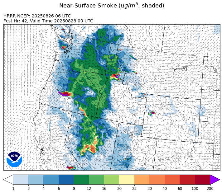
Source: HRRR-smoke
Forecast
Monsoonal moisture begins to impact southwest Montana starting Tuesday afternoon. Wildfire activity around central Idaho and western Montana was active again on Monday. However, the monsoonal moisture will be accompanied by increasing relative humidity and cloud cover, both features should help to moderate fire behavior. A light easterly flow should keep the bulk of the smoke from the central Idaho fires west of the Montana/Idaho border.
On Wednesday, the monsoonal moisture becomes better established across western and southwest Montana. This will lead to better chances for beneficial rainfall. The precipitation will come in the form of thunderstorms and with dry fuel moistures in place, there is a threat for new fire starts, particularly over southwest Montana.
By Thursday and Friday, precipitation chances for central, west, and southwest gradually increase. Some of the storms will be accompanied by very heavy rainfall and gusty winds. The rainfall should help to moderate fire behavior and reduce smoke production on regional wildfires. Unfortunately, this precipitation is unlikely to bring an end to the fire season across the Northern Rockies. Stay tuned!
Conditions can change quickly as weather could stimulate active fires and the likelihood of new starts increases. Please keep track of concentrations at todaysair.mtdeq.us or the Fire and Smoke Map.
Tuesday morning’s satellite image shows some smoke over northwest Montana as clouds increase across the state thanks to monsoonal moisture.
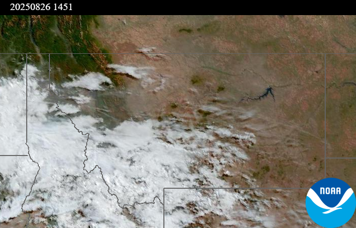
Source: NOAA
| Incident Name | State | Location | Acres | Containment |
|---|---|---|---|---|
| Rock Fire | Idaho | 5 miles southwest of Donnelly, ID | 2792 | 37% |
| Sunset Fire | Idaho | 26 Miles N of Coeur d'Alene, ID | 3230 | 42% |
| Island Creek | Idaho | Near Sob Point on the Moose Creek Ranger District. | 10743 | 5% |
| Mire | Idaho | Approximately 22 miles West/NW of Powell Idaho | 467 | 0% |
| Twin | Idaho | 29 air miles northeast of Headquarters, ID in Twin Cabin Creek drainage, a tributary to Quartz Creek on the North Fork Ranger District. | 272 | 0% |
| Lightning Creek Fire | Idaho | 9 miles north of Clark Fork, ID | 2515 | 15% |
| Rush | Idaho | 57 Miles NW of McCall, Idaho - Frank Church-River of No Return Wilderness | 7908 | 90% |
| Big Bear | Idaho | 59 Miles NE of McCall, Idaho - Frank Church-River of No Return Wilderness | 15517 | 70% |
| Shingle | Idaho | NA | 100 | 55% |
| Cedar Fire | Idaho | approximately 4 miles northeast of Clyde | 898 | 90% |
| Elkhorn Fire | Idaho | 45 Miles E of Challis, ID | 1213 | 0% |
| Windy Rock Fire | Montana | 15 Miles NE of Drummond, MT | 3368 | 0% |
| Corral Creek Fire | Montana | 4.5 miles south of Huson, MT | 368 | 0% |
| Bivens Creek | Montana | 15 Miles North of Virginia City, MT | 2233 | 34% |
| Cloudrest | Montana | 15 Miles northwest of Virginia City, MT | 2629 | 12% |
| Sandbar 2 Fire | Montana | 15 miles east of Lincoln, Montana; north of Montana State Highway 279 and Flesher Pass | 242 | 29% |
| Ransome Fire | Montana | 11 Miles northwest of Libby, MT | 473 | 0% |
| Knowles Fire | Montana | 11 Miles E of Plains, MT | 3638 | 16% |
| West Fork Fire | Montana | 23 Miles NW of West Yellowstone, MT, Custer Gallatin National Forest | 619 | 33% |
| McAllister Fire | Montana | Madison County, 3 miles south of Norris, 3 miles north of Ennis Lake | 3560 | 85% |
| Gill Gulch Fire | Montana | 7 Miles south of Lincoln, MT | 34 | 50% |
| Flat Fire | Oregon | 2 Miles Northeast of Sisters, OR | 21971 | 7% |
| Emigrant Fire | Oregon | 3 miles southwest of Indigo Springs Campground | 1200 | 0% |
| Butte Creek | Oregon | 2 miles west of Simnasho, Oregon | 2079 | 85% |
| Hagelstein Fire | Oregon | 14 miles north of Klamath Falls, Oregon | 669 | 75% |
| Elk Fire | Oregon | 7 miles SW of Beatty, Oregon | 2637 | 95% |
| Pomas Fire | Washington | Approximately 36 miles northwest of Entiat, WA | 3533 | 0% |
| Bear Gulch Fire | Washington | 10 Miles Northwest of Hoodsport, WA | 8702 | 13% |
| Bear Creek II | Washington | 18 miles N of Keller, WA | 267 | 70% |
Tags: Smoke Forecast 2025