
Smoke Forecast for Monday, August 25, 2025 9:30 AM
Current Conditions
An Air Resource Advisor has been assigned to the Bivens Creek and Cloudrest fires burning near Twin Bridges. For more information on these fires click here.
Wildfire activity increased on most regional wildfires over the weekend. That should continue again Monday with unseasonably warm air and gusty afternoon winds.
The Knowles and Mile Marker 91 fires burning near Paradise, Montana, saw a decrease in fire activity over the weekend, as firefighters start to get a handle on these blazes. Two wildfires burning in the Tobacco Root Mountains continue to expand. Expect some downstream impacts in the coming days from the Bivens Creek and Cloudrest fires. The West Fork fire burning just north of Hebgen Lake was very active again over the weekend. The fire has burned 556 acres and is now 30% contained. The Windy Rock fire, burning 15 miles northeast of Drummond, remains active. It is up to 2,723 acres and is 0% contained. The Devil Mountain fire, just north of the Windy Rock blaze, experienced rapid fire growth over the weekend thanks to gusty northeasterly winds. The Ransome fire, burning just north of Libby, exhibited active fire behavior over the weekend. It has grown to 300 acres and is 0% contained. Northerly transport winds will send some smoke into Libby on Monday. Over the weekend, there were several active wildfires burning just west of Ravalli County in central Idaho. The largest of these fires is Island Creek, which has grown to 10,743 acres and is only 5% contained. Northerly transport winds on Monday should keep the bulk of the smoke west of Montana.
At 9:00 AM Monday, Missoula, Hamilton, Frenchtown, Seeley Lake, Thompson Falls, Sleeping Giant, Butte, Dillon and Great Falls’ air quality is Moderate.
By Tuesday evening, the High-Resolution Rapid Refresh (HRRR) smoke model shows surface smoke impacting the western third of Montana from regional wildfires.
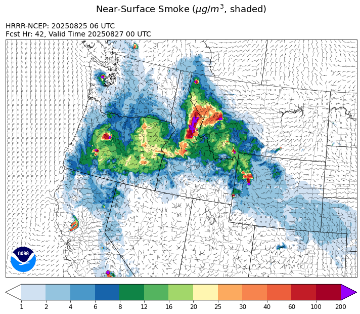
Source: HRRR-smoke
Forecast
The ridge of high pressure responsible for the warm, dry conditions over the Northern Rockies will gradually weaken and shift east. The region can expect one more warm day on Monday with highs approaching the low 90s. Numerous active wildfires over central Idaho will focus the greatest smoke impacts across Ravalli and Beaverhead Counties to start the week. However, northerly transport winds should keep the bulk of the smoke west of Montana again on Monday.
Monsoonal moisture surges north into the Treasure state between Tuesday and Friday. Precipitation should gradually push north each day this week, with the best chances for precipitation between Wednesday and Thursday. The heaviest precipitation will be focused over areas mainly south of I-90. The precipitation should help moderate fire behavior and limit smoke production. However, strong outflow winds from a few of the thunderstorms could increase fire behavior around active wildfires. Thankfully, most forecast models indicate a good soaking for central Idaho as well.
Most long-range models keep the monsoonal moisture lingering over the area through the weekend. This should keep precipitation in the forecast and help to keep regional wildfires activity in check. Expect an overall decrease in fire activity and a reduction in surface smoke in this pattern. Stay tuned!
Conditions can change quickly as weather could stimulate active fires and the likelihood of new starts increases. Please keep track of concentrations at todaysair.mtdeq.us or the Fire and Smoke Map.
Monday morning’s satellite image shows some smoke over southwest Montana from numerous regional wildfires.
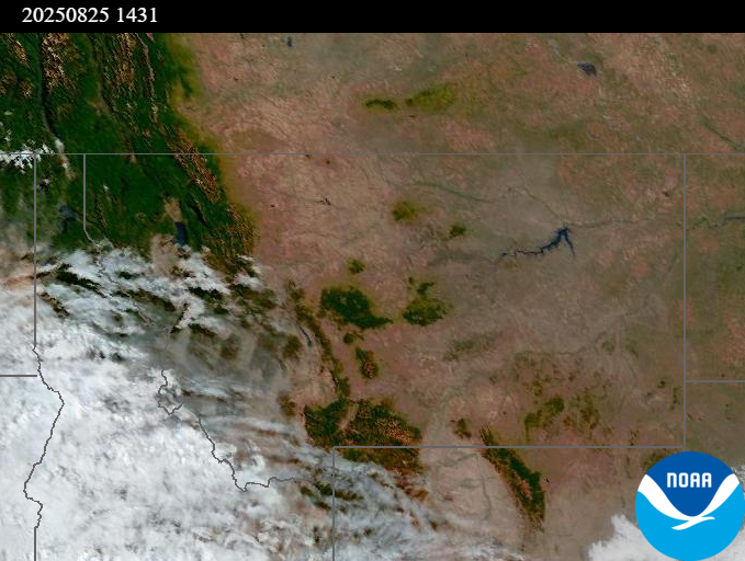
Source: NOAA
| Incident Name | State | Location | Acres | Containment |
|---|---|---|---|---|
| Mire | Idaho | Approximately 22 miles West/NW of Powell Idaho | 467 | NA |
| Rock Fire | Idaho | 5 miles southwest of Donnelly, ID | 2792 | 29% |
| Sunset Fire | Idaho | 26 Miles N of Coeur d'Alene, ID | 3230 | 32% |
| Island Creek | Idaho | Near Sob Point on the Moose Creek Ranger District. | 10743 | 5% |
| Twin | Idaho | 29 air miles northeast of Headquarters, ID in Twin Cabin Creek drainage, a tributary to Quartz Creek on the North Fork Ranger District. | 272 | NA |
| Lightning Creek Fire | Idaho | 9 miles north of Clark Fork, ID | 2515 | 15% |
| Rush | Idaho | 57 Miles NW of McCall, Idaho - Frank Church-River of No Return Wilderness | 7908 | 90% |
| Big Bear | Idaho | 59 Miles NE of McCall, Idaho - Frank Church-River of No Return Wilderness | 15517 | 70% |
| Elkhorn Fire | Idaho | Krassel Ranger District, Payette National Forest | 26048 | NA |
| Shingle | Idaho | NA | 100 | NA |
| Cedar Fire | Idaho | approximately 4 miles northeast of Clyde | 898 | 90% |
| Elkhorn Fire | Idaho | 45 Miles E of Challis, ID | 1213 | 0% |
| Knowles Fire | Montana | 11 Miles E of Plains, MT | 3638 | 16% |
| Windy Rock Fire | Montana | 15 Miles NE of Drummond, MT | 3368 | 0% |
| West Fork Fire | Montana | 23 Miles NW of West Yellowstone, MT, Custer Gallatin National Forest | 755 | 30% |
| Cloudrest | Montana | 15 Miles northwest of Virginia City, MT | 2565 | 0% |
| Bivens Creek | Montana | 15 Miles North of Virginia City, MT | 2238 | 0% |
| Sandbar 2 Fire | Montana | 15 miles east of Lincoln, Montana; north of Montana State Highway 279 and Flesher Pass | 243 | 17% |
| Corral Creek Fire | Montana | 4.5 miles south of Huson, MT | 408 | 0% |
| McAllister Fire | Montana | Madison County, 3 miles south of Norris, 3 miles north of Ennis Lake | 3560 | 50% |
| Horn Fire | Montana | Madison County, between Cliff Lake and Highway 87 | 2800 | 95% |
| Gill Gulch Fire | Montana | 7 Miles south of Lincoln, MT | 34 | 50% |
| Flat Fire | Oregon | 7 miles west of Culver, Oregon | 18594 | 0% |
| Butte Creek | Oregon | 2 miles west of Simnasho, Oregon | 2079 | 85% |
| Hagelstein Fire | Oregon | 14 miles north of Klamath Falls, Oregon | 669 | 75% |
| Elk Fire | Oregon | 7 miles SW of Beatty, Oregon | 2637 | 95% |
| Bear Gulch Fire | Washington | 10 Miles Northwest of Hoodsport, WA | 8517 | 13% |
| Pomas Fire | Washington | Approximately 36 miles northwest of Entiat, WA | 3533 | NA |
| Crescent Road | Washington | 7 Miles N of Reardan, WA | 881 | 95% |
| Bear Creek II | Washington | 18 miles N of Keller, WA | 267 | 70% |
| Castle Rock Fire | Washington | 6 Miles SE of Colville, WA | 58 | 99% |
Tags: Smoke Forecast 2025