
Smoke Forecast for Friday, August 22, 2025 9:30 AM
Current Conditions
Warm air and an easterly flow will lead to more active fire behavior on regional wildfires through Saturday.
The Knowles and Mile Marker 91 fires burning near Paradise, Montana, were active again on Thursday. Two wildfires burning in the Tobacco Root Mountains continue to expand. Expect some downstream impacts in the coming days from the Bivens Creek and Cloudrest fires. The West Fork fire burning just north of Hebgen Lake was very active again on Thursday. An easterly flow will send smoke into southern Madison and Beaverhead Counties. The Windy Rock fire, burning 15 miles northeast of Drummond, continues to expand. It is up to 1,316 acres and is 0% contained. The Devil Mountain fire, just north of the Windy Rock blaze, quickly grew to 372 acres on Thursday. Easterly transport winds will send smoke from these wildfires into portions of the Missoula and Bitterroot Valleys through Saturday. The Sandbar 2 fire, burning 15 miles east of Lincoln, was discovered on Tuesday. It is expected to expand in the next 48-hours. The Pot Mountain fire, burning in the Bob Marshall Wilderness, was active again on Thursday. The Ransome fire, burning just north of Libby, exhibited active fire behavior on Thursday. It will send smoke into the Idaho Panhandle through Saturday. The Island Creek fire, burning in central Idaho, exhibited active fire behavior again on Thursday. Fortunately for Montana, easterly transport winds should keep most of the smoke from this fire out of the Bitterroot Valley through Saturday.
At 9:00 AM Friday, Frenchtown, Hamilton, Dillon, Sidney, Missoula, Butte, Seeley Lake, and Great Falls’ air quality is Moderate.
By Saturday afternoon, the High-Resolution Rapid Refresh (HRRR) smoke model shows light easterly transport winds pushing smoke from regional wildfires off to the west.
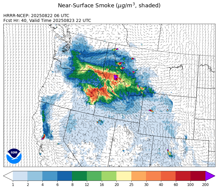
Source: HRRR-smoke
Forecast
High pressure will dominate the weather story across the state on Friday and continue through the weekend. It will produce several consecutive hot and dry days for the Northern Rockies. Regional smoke could limit how warm it gets in the afternoon, particularly for communities adjacent to some of the larger wildfires. Easterly transport winds on Friday will send smoke from the Windy Rock fire into the Missoula and Bitterroot Valleys at times. Expect some surface smoke at times over the Flathead Valley from the Pot Mountain fire.
On Saturday, the flow weakens but will still be light and out of the east. This will tend to limit smoke impacts from regional wildfires to areas closer to the fire itself. Thanks to high pressure, the diurnal impacts from smoke will become even more exaggerated. Smoke will drain and pool overnight, leading to deteriorating air quality for communities adjacent to many of the wildfires.
Monsoonal moisture will begin to creep north into the Treasure State starting Sunday. It will introduce the threat for a scattered thunderstorm or two. However, most long-range models don’t show any widespread precipitation for the area until around midweek. Stay tuned!
Conditions can change quickly as weather could stimulate active fires and the likelihood of new starts increases. Please keep track of concentrations at todaysair.mtdeq.us or the Fire and Smoke Map.
Friday morning’s air quality worm plots show several communities in western Montana with PM2.5 smoke impacts due to regional wildfires over the last 48-hours.
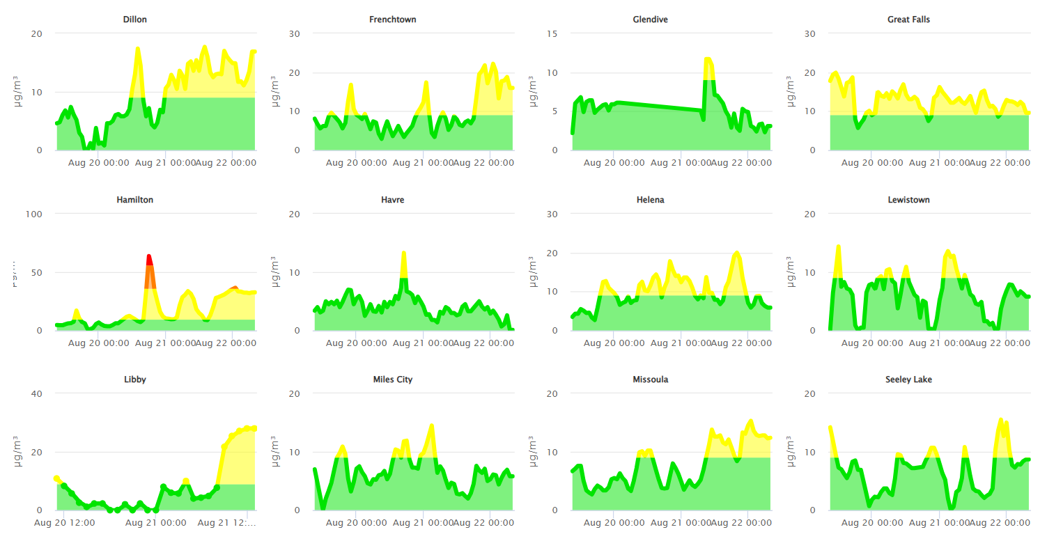
Source: DEQ Analysis
| Incident Name | State | Location | Acres | Containment |
|---|---|---|---|---|
| Lightning Creek Fire | Idaho | 9 miles north of Clark Fork, ID | 2515 | 15% |
| Rock Fire | Idaho | 5 miles southwest of Donnelly, ID | 2813 | 0% |
| Sunset Fire | Idaho | 26 Miles N of Coeur d'Alene, ID | 3208 | 11% |
| Island Creek | Idaho | Near Sob Point on the Moose Creek Ranger District. | 6831 | 5% |
| Rush | Idaho | 57 Miles NW of McCall, Idaho - Frank Church-River of No Return Wilderness | 7908 | 90% |
| Big Bear | Idaho | 59 Miles NE of McCall, Idaho - Frank Church-River of No Return Wilderness | 15517 | 70% |
| Mire | Idaho | Approximately 22 miles West/NW of Powell Idaho | 100 | 0% |
| Elkhorn Fire | Idaho | Krassel Ranger District, Payette National Forest | 26048 | 0% |
| Shingle | Idaho | NA | 100 | 55% |
| Cedar Fire | Idaho, United States | approximately 4 miles northeast of Clyde | 898 | 90% |
| Elkhorn Fire | Idaho, United States | 45 Miles E of Challis, ID | 1213 | 0% |
| Knowles Fire | Montana | 11 Miles E of Plains, MT | 1948 | 0% |
| Corral Creek Fire | Montana | 4.5 miles south of Huson, MT | 210 | 0% |
| Windy Rock Fire | Montana | 15 Miles NE of Drummond, MT | 1316 | 0% |
| Cloudrest | Montana | 15 Miles northwest of Virginia City, MT | 1733 | 0% |
| Bivens Creek | Montana | 15 Miles North of Virginia City, MT | 2219 | 0% |
| McAllister Fire | Montana | Madison County, 3 miles south of Norris, 3 miles north of Ennis Lake | 3560 | 50% |
| West Fork Fire | Montana | Custer Gallatin National Forest | 650 | 5% |
| Sandbar 2 Fire | Montana | 15 miles east of Lincoln, Montana; north of Montana State Highway 279 and Flesher Pass | 240 | 0% |
| Horn Fire | Montana | Madison County, between Cliff Lake and Highway 87 | 2800 | 95% |
| Gill Gulch Fire | Montana | 7 Miles south of Lincoln, MT | 34 | 50% |
| Butte Creek | Oregon | 2 miles west of Simnasho, Oregon | 2079 | 85% |
| Hagelstein Fire | Oregon | 14 miles north of Klamath Falls, Oregon | 669 | 75% |
| Elk Fire | Oregon | 7 miles SW of Beatty, Oregon | 2637 | 95% |
| Bear Gulch Fire | Washington | 10 Miles Northwest of Hoodsport, WA | 8373 | 11% |
| Crescent Road | Washington | 7 Miles N of Reardan, WA | 881 | 95% |
| Pomas Fire | Washington | Approximately 36 miles northwest of Entiat, WA | 3533 | 0% |
| Bear Creek II | Washington | 18 miles N of Keller, WA | 267 | 70% |
| Castle Rock Fire | Washington | 6 Miles SE of Colville, WA | 58 | 99% |
| Red Canyon Fire | Wyoming | Hot Springs County | 124701 | 48% |
| Sleeper Ranch Fire | Wyoming | Park County, Wyoming | 18298 | 0% |
| Vees Fire | Wyoming | 13 Miles South of Ten Sleep, WY. 45 Miles Southeast of Worland, WY. | 5229 | 94% |
Tags: Smoke Forecast 2025