
Smoke Forecast for Wednesday, August 20, 2025 9:30 AM
Current Conditions
Unseasonably warm temperatures, gusty winds, and dry fuels led to more active fire behavior on several wildfires on Tuesday.
The Knowles and Mile Marker 91 fires burning near Paradise, Montana, were active again on Tuesday. These fires will continue to send smoke into portions of Lake and Flathead Counties on Wednesday. An unnamed fire burning in the Flathead National Forest was active on Tuesday. Westerly transport winds will send smoke from this fire into portions of Pondera and Teton Counties. Two wildfires burning in the Tobacco Root Mountains continue to expand. Expect some downstream impacts in the coming days from the Bivens Creek and Cloudrest fires. An unnamed fire burning just north of Hebgen Lake was very active on Tuesday. It will send smoke on Wednesday into portions of Yellowstone National Park. The Red Canyon fire, burning in north central Wyoming, has grown to 113,774 acres. It will continue sending some surface smoke into sections of southeast Montana. The Windy Rock fire, burning 15 miles northeast of Drummond, is expected to grow in the coming days. Communities downwind of this fire like Helena should expect to see increasing smoke as a result.
At 9:00 AM Wednesday, Great Falls’ air quality is Moderate.
By Thursday morning, the High-Resolution Rapid Refresh (HRRR) smoke model shows surface smoke from regional wildfires impacting much of the state.
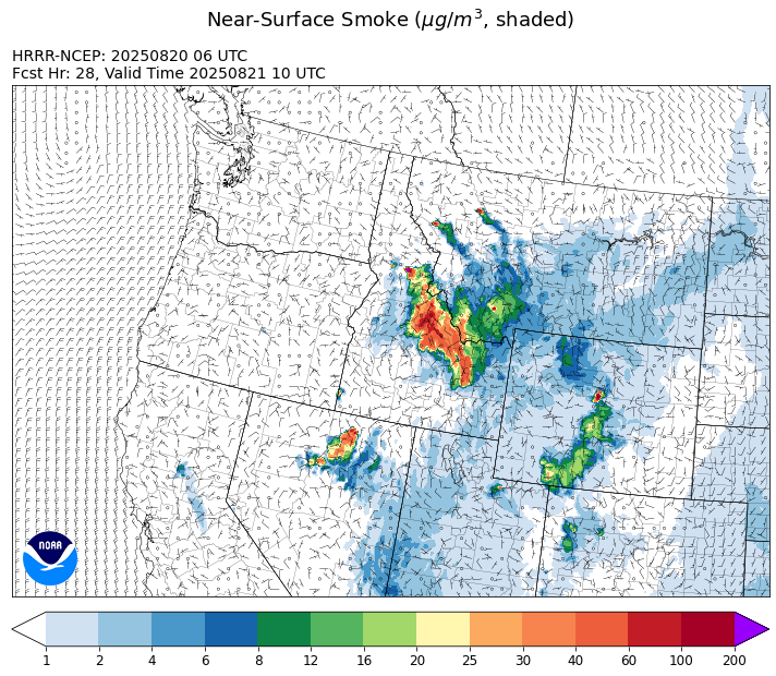
Source: HRRR-smoke
Forecast
A weak cool front will march across the Treasure State on Wednesday. It will produce slightly cooler temperatures and gusty westerly winds. These gusty winds will lead to another round of active fire behavior on numerous regional blazes starting Wednesday afternoon. On Tuesday, the most active wildfires in the state were burning near Paradise, an unnamed fire in the Flathead National Forest, and two wildfires burning in the Tobacco Root Mountains. Westerly transport winds on Wednesday will send smoke into communities on the east side of these fires. Smoke models are showing this westerly flow sending smoke from multiple fires in central Idaho into Ravalli and Beaverhead Counties over the next 48-hours.
Cooler and more seasonable temperatures will arrive Friday and linger into the weekend. An upper-level ridge builds across much of the western United States. A northwesterly flow will prevent temperatures from getting too hot. Expect the usual diurnal behavior to smoke production in this pattern. As winds pick up around midday, fire behavior increases along with smoke production. Overnight, expect smoke to drain and pool into communities adjacent to the most active wildfires, leading to deteriorating air quality.
By late next week, many long-range models are hinting at increasing monsoonal moisture creeping northward into Montana. If this were to occur, precipitation chances would increase, and fire behavior would be moderated. Right now, the bulk of this precipitation looks to impact the southern half of the state. Stay tuned!
Conditions can change quickly as weather could stimulate active fires and the likelihood of new starts increases. Please keep track of concentrations at todaysair.mtdeq.us or the Fire and Smoke Map.
Wednesday morning’s satellite shows some smoke across the southern half of the state from regional wildfires.
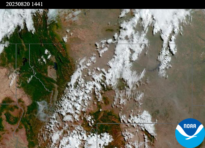
Source: NOAA
| Incident Name | State | Location | Acres | Containment |
|---|---|---|---|---|
| Rock Fire | Idaho | 5 miles southwest of Donnelly, ID | 2743 | 0% |
| Sunset Fire | Idaho | 26 Miles N of Coeur d'Alene, ID | 3208 | 4% |
| Lightning Creek Fire | Idaho | 9 miles north of Clark Fork, ID | 2515 | 25% |
| Island Creek | Idaho | Near Sob Point on the Moose Creek Ranger District. | 1000 | 5% |
| Mire | Idaho | Approximately 22 miles West/NW of Powell Idaho | 100 | 0% |
| Rush | Idaho | 57 Miles NW of McCall, Idaho - Frank Church-River of No Return Wilderness | 7539 | 90% |
| Big Bear | Idaho | 59 Miles NE of McCall, Idaho - Frank Church-River of No Return Wilderness | 15217 | 70% |
| Elkhorn Fire | Idaho | Krassel Ranger District, Payette National Forest | 26048 | 0% |
| Shingle | Idaho | NA | 100 | 55% |
| Cedar Fire | Idaho | approximately 4 miles northeast of Clyde | 898 | 86% |
| Elkhorn Fire | Idaho | 45 Miles E of Challis, ID | 953 | 0% |
| Cloudrest | Montana | 15 Miles northwest of Virginia City, MT | 1190 | 0% |
| Bivens Creek | Montana | 15 Miles North of Virginia City, MT | 2267 | 0% |
| Windy Rock Fire | Montana | 15 Miles NE of Drummond, MT | 872 | 0% |
| Knowles Fire | Montana | 11 Miles E of Plains, MT | 745 | 0% |
| Horn Fire | Montana | Madison County, between Cliff Lake and Highway 87 | 2800 | 75% |
| McAllister Fire | Montana | Madison County, 3 miles south of Norris, 3 miles north of Ennis Lake | 3500 | 30% |
| Gill Gulch Fire | Montana | 7 Miles south of Lincoln, MT | 34 | 35% |
| Butte Creek | Oregon | 2 miles west of Simnasho, Oregon | 2079 | 85% |
| Hagelstein Fire | Oregon | 14 miles north of Klamath Falls, Oregon | 669 | 75% |
| Elk Fire | Oregon | 7 miles SW of Beatty, Oregon | 2637 | 95% |
| Crescent Road | Washington | 7 Miles N of Reardan, WA | 881 | 81% |
| Pomas Fire | Washington | Approximately 36 miles northwest of Entiat, WA | 3533 | 0% |
| Bear Gulch Fire - WAOLF | Washington | 10 Miles Northwest of Hoodsport, WA | 8373 | 7% |
| Bear Creek II - | Washington | 18 miles N of Keller, WA | 267 | 70% |
| Castle Rock Fire | Washington | 6 Miles SE of Colville, WA | 58 | 99% |
| Red Canyon Fire | Wyoming | Hot Springs County | 113774 | 28% |
| Sleeper Ranch Fire | Wyoming | Park County, Wyoming | 18298 | 0% |
| Vees Fire | Wyoming | 13 Miles South of Ten Sleep, WY. 45 Miles Southeat of Worland, WY. | 5229 | 94% |
Tags: Smoke Forecast 2025