
Smoke Forecast for Wednesday, August 19, 2026 9:00 AM
Current Conditions
An Air Resource Advisor has been assigned to the Sand Creek and Bobcat Lakes Fires.
Air quality has gradually deteriorated across the western half of the state over the last 24-hours. Warmer temperatures and gusty afternoon winds produced more active fire behavior over central and northern Idaho on Tuesday. Westerly transport winds will send smoke into Ravalli, Missoula, Sanders, and Mineral Counties again by Wednesday afternoon.
As of 8 AM, particulate levels in Great Falls, Cut Bank, Missoula, Frenchtown, Butte, Hamilton, Columbia Falls, Lewistown, Malta, Havre, Helena, Sleeping Giant, Thompson Falls, and Libby are moderate.
By Thursday afternoon, the Rapid Refresh Forecast System (RRFS) smoke increasing smoke production on regional wildfire and mainly light surface smoke across parts of the state.
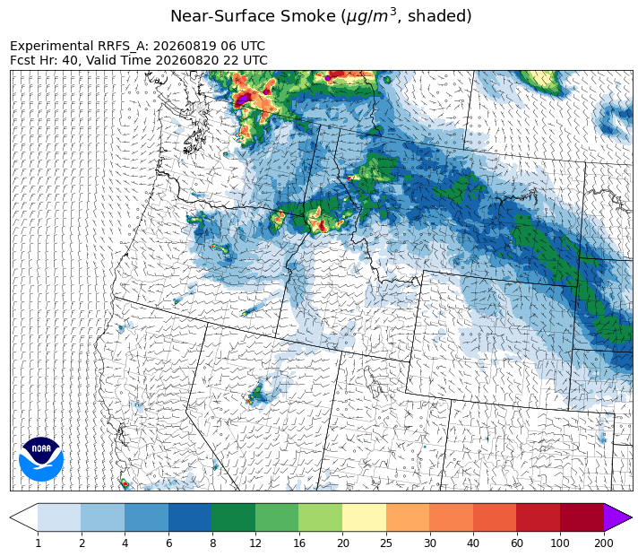
Source: HRRR-smoke
Forecast
High pressure builds over the region through the end of the week. This will provide hot, dry, and windy conditions around the region, with fire behavior becoming increasingly active as the week goes on. Transport winds will remain out of the west, pushing smoke from upstream wildfire in Oregon, Washington, and Idaho into the Treasure State. As fire behavior increases on regional wildfires, so will surface smoke production.
Some monsoonal moisture is possible around the region on Friday. This could be enough to trigger a few widely scattered showers and thunderstorms. The ridge breaks down this weekend, setting the stage for additional chances for rain. Unfortunately, this system is unlikely to produce a widespread rain event for Montana.
On Monday, a ridge of high pressure builds back over the state. This will produce more hot, dry, and windy conditions. It will also bring more active fire weather conditions on regional blazes. One potential silver lining as we head towards late August and September is the decreasing sun angle this time of year. Fires perk up later in the morning and calm down earlier in the afternoon compared to earlier in the summer, shortening the daily burning window. Stay tuned!
Conditions can change quickly as weather could stimulate active fires and the likelihood of new starts increases. Please keep track of concentrations at todaysair.mtdeq.us or the Fire and Smoke Map.
Wednesday morning’s satellite image reveals more wildfire smoke over the region, particularly the northern half of Montana.
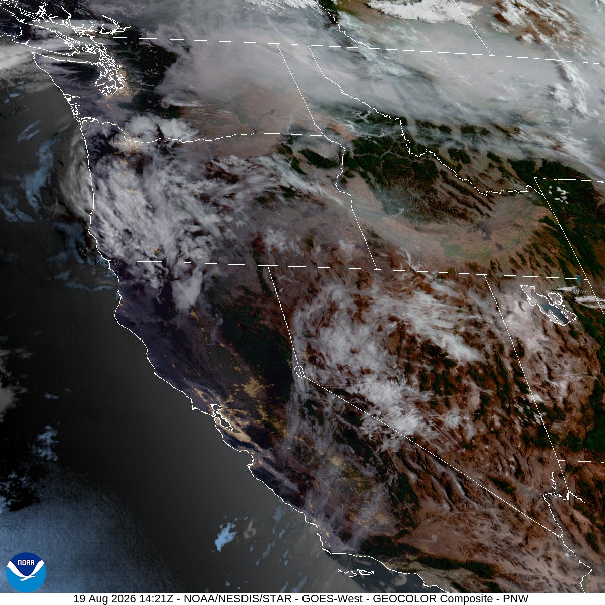
Source: NOAA
| Incident Name | State | Location | Acres | Containment |
|---|---|---|---|---|
| Moose Mountain | Idaho | Approximately 4 miles north of Kelly Forks Camp Ground | 2884 | 7% |
| Upper Smith Fire | Idaho | Six miles West of Porthill, Idaho | 3697 | 38% |
| Little Weitas | Idaho | Approximately 19 miles East of Peirce, Idaho | 400 | NA |
| Porcupine Fire | Idaho | Approximately 7 miles NE of Clark Fork, ID. | 115 | 0% |
| Tartar | Idaho | 21 Miles NW of Weiser, ID | 158027 | 98% |
| Cascade | Idaho | 22 miles East of Lowell, Idaho | 3300 | NA |
| Chimney Fire | Idaho | 9 miles northwest of Fairfield, ID | 6521 | 80% |
| Claremont Fire | Idaho | 1 mile NE of Boise, Idaho | 6606 | 90% |
| Duncan | Idaho | 50 Miles SW of Mountain Home, ID | 16362 | 70% |
| Double Springs Fire | Idaho | 31 miles Northwest of Mackay , ID | 1779 | 18% |
| Moose Fire | Montana | 24 miles southwest of Philipsburg | 5892 | 6% |
| Bobcat Lakes | Montana | 12 miles east of Wisdom | 9892 | 40% |
| Sand Creek | Montana | 7.5 miles southeast of Wisdom, Montana | 31667 | 7% |
| Silvertip Fire | Montana | NA | 6681 | 15% |
| Skillet Fire | Montana | 15 miles west of Olney, MT | 3364 | 82% |
| Ant Park | Montana | NA | NA | NA |
| North Fork Fire | Montana | 10 miles southwest of Hamilton, MT, north of North Fork Lost Horse Creek | 118 | 70% |
| Black Bear Fire | Montana | 15 Miles E of Hamilton, MT | 2145 | 20% |
| Paradise Fire | Oregon | 15 miles south of Pendleton Oregon | 5423 | 0% |
| Hagen Fire | Oregon | 26 Miles East of Pendleton, OR | 57678 | 19% |
| Austin Fire | Oregon | 25 Miles SE of Estacada, OR | 3244 | 0% |
| Grasshopper Fire | Oregon | 3 miles North of Sportmans Park, OR | 92408 | 61% |
| Jackass Butte | Oregon | 40 Miles S of Burns, OR | 24724 | 92% |
| Bald Mountain | Oregon | 50 Miles SE of Burns, OR | 76443 | 95% |
| Coleman Creek | Oregon | ~1 mile southeast of Juntura | 308721 | 95% |
| Second Flat | Oregon | Six miles NE of Riley, OR | 105854 | 95% |
| Wrights Spring | Oregon | 2 Miles W of Sprague River OR | 54016 | 55% |
| Big Grass Fire | Oregon | Malheur County, Oregon and Owyhee County, Idaho | 579169 | 85% |
| Little Bear | Oregon | 8 Miles NE of Mt. Vernon, OR | 67 | 95% |
| Bologna Fire | Oregon | 7 miles northeast of Kimberly, OR | 4509 | 89% |
| Cottonwood Fire | Oregon | 15 miles southwest of Long Creek, Oregon | 722 | 95% |
| Rosenbaum Fire | Oregon | 10 Miles NW of Spray, OR | 483 | 51% |
| Rowe Creek Complex | Oregon | 10 Miles S of Fossil, OR | 373785 | 89% |
| Shingle Fire | Oregon | 14 Miles SE of Mitchell, OR | 73183 | 91% |
| Henry Fire | Oregon | 5 Miles S of PAULINA GUARD STATION, OR | 29850 | 97% |
| Coyote Fire | Oregon | 5 miles south of Post, OR | 17459 | 88% |
| Picture Rock | Oregon | 3 Miles N of Summer Lake, OR | 1277 | 20% |
| Fielder Mountain | Oregon | 1 mile west of Rogue River, OR | 573 | 38% |
| Castle | Oregon | 23 Miles NE of Tiller, OR | 3613 | 94% |
| Fox Fire | Oregon | 12 Miles NE of Huntington, OR | 78903 | 90% |
| Powder River Fire | Oregon | 4 Miles SW of RICHLAND, OR | 21088 | 96% |
| Horse Ridge Fire | Oregon | 25 Miles East of Pendleton, OR | 860 | 98% |
| Burnt Creek Fire | Oregon | 23 Miles N of Enterprise, OR | 4169 | 87% |
| Bench | Oregon | 4 miles south of Warm Springs, OR | 67071 | 86% |
| Salmon Fire | Oregon | 34 Miles SW of Baker City, OR | 1433 | 88% |
| Akawa Butte Fire | Oregon | 13 Miles NE of Sisters, OR | 27491 | 99% |
| Hat Fire | Oregon | 40 Miles East of Burns, OR | 44122 | 99% |
| Hay Creek Complex | Oregon | Gilliam, Sherman and Wasco counties, Oregon | 200292 | 97% |
| Anthony Fire | Oregon | 34 miles north of Baker City, OR | 2585 | 89% |
| Stubble | Oregon | 15 Miles SW of Lawen, OR | 15673 | 87% |
| Crater | Oregon | 35 Miles S of Burns, OR | 745 | 93% |
| Egypt Fire | Oregon | 12 Miles N of Riley, OR | 4595 | 68% |
| North Cayuse Fire | Oregon | 15 miles east of Pendleton, OR. | 4887 | 91% |
| Little Giant Fire | Washington | 30 miles NW of Leavenworth, WA | 137294 | 10% |
| Kaiser Canyon | Washington | 1 mile S of Nespelem, WA | 138292 | 89% |
| Modrite Fire | Washington | 17 Miles SW of Inchelium, WA | 57594 | 97% |
| Three Queens | Washington | 6 Miles E of Snoqualmie Pass, WA | 3793 | 2% |
| Grand Park 2 Fire | Washington | Seven miles southwest of Snoquera, WA | 167 | 65% |
| Luna Fire | Washington | 10 Miles North of Newhalem, WA | 4477 | 0% |
| Backbone | Washington | 7 miles north-east of Packwood, Washington | 15 | 0% |
| High Lava Fire | Washington | 11 Miles NW of Stabler, WA | 1405 | 8% |
| Reevas Basin | Washington | 3 Miles SE of Tonasket, WA | 233 | 60% |
| Sinlahekin Fire | Washington | 12 Miles W of Tonasket, WA | 154162 | 44% |
| Border 2 Fire | Washington | 20 Miles NE of Marblemount, WA | 7296 | 31% |
| Ptarmigan Fire | Washington | 20 Miles NW of Mazama, WA | 24647 | 55% |
| Mount Tom Creek Fire | Washington | Olympic National Park | 69 | 75% |
| Hudspeth Fire | Washington | 3 miles northeast of Hunters, Washington | 6726 | 96% |
| Bradeen Hill Fire | Washington | 17 Miles SW of Colville, WA | 4417 | 92% |
| Spokane Area Fires | Washington | Spokane County, Washington | 9932 | NA |
| Wells Road Fire | Washington | 14 Miles NE of St John, WA | 1865 | 78% |
| Skyo Fire | Washington | 3 Miles SW of Packwood, WA | 254 | 83% |
| Chelan Hills | Washington | 1 Mile N of Orando | 9735 | 75% |
Tags: smoke forecast