
Smoke Forecast for Tuesday, August 19, 2025 9:30 AM
Current Conditions
Regional wildfire activity started to pick up on Monday thanks to moderating temperatures and drying fuel moistures.
On Monday, the Knowles and Mile Marker 91 fires burning near Paradise, Montana, were active. These fires will continue to send smoke into portions of Lake and Flathead Counties. The Island Creek fire, burning in central Idaho, exhibited active fire behavior on Monday, occasionally sending smoke into Ravalli County. Expect similar behavior over the next 48-hours thanks to moderating temperatures and southwesterly transport winds. Two wildfires burning in the Tobacco Root Mountains have grown quickly over the last 48-hours. Expect some downstream impacts in the coming days. The Red Canyon fire, burning in north central Wyoming, has grown to 107,885 acres. It will continue sending some surface smoke into sections of southeast Montana. Thanks to recent rainfall, fire behavior on the Windy Rock fire has moderated some. The fire is well-staffed with a crew of 285 assigned to it.
At 9:00 AM Tuesday, Great Falls’ air quality is Moderate.
By Wednesday evening, the High-Resolution Rapid Refresh (HRRR) smoke model shows light surface smoke from regional wildfires impacting much of the state.
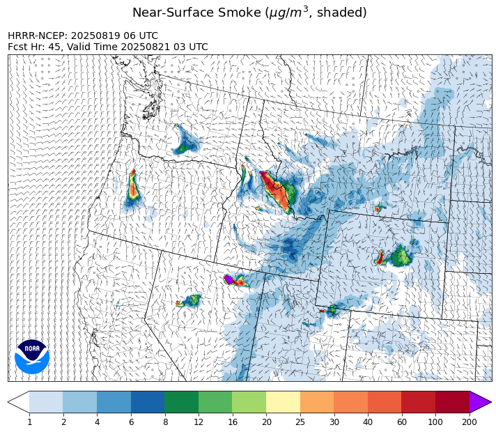
Source: HRRR-smoke
Forecast
A southwesterly flow will continue again on Tuesday. It will pump anomalously moist air into the state, kicking off scattered showers and thunderstorms. There were hundreds of lightning strikes across the region over the weekend because of widespread thunderstorms. Unseasonably warm air and gusty afternoon winds could lead to new fire starts from the weekend’s lightning activity. Two fires near Paradise, Montana were active again on Monday. Expect some smoke impacts over the Flathead Valley as southwesterly winds transport this smoke over Lake and Flathead Counties. The Island Creek fire, burning in central Idaho, will send some surface smoke into the western third of Montana by Tuesday afternoon. Lastly, the Red Canyon fire, burning in north-central Wyoming, will send some surface smoke into parts of southeast Montana.
A mostly dry front will march across the Treasures State on Wednesday. It will bring slightly cooler air, but gusty westerly winds. These gusty winds could provide more active fire behavior and increased surface smoke for communities adjacent to some of the larger wildfires.
A sprawling ridge of high pressure is expected to build over the Northern Rockies starting Thursday and Friday. It will bring northwesterly transport winds along with seasonably warm temperatures. Most long-range models are starting to indicate that monsoonal moisture will be on the increase by this weekend. If this verifies, precipitation will become more widespread, particularly across the southern half of the state. Stay tuned!
Conditions can change quickly as weather could stimulate active fires and the likelihood of new starts increases. Please keep track of concentrations at todaysair.mtdeq.us or the Fire and Smoke Map.
Tuesday morning’s satellite shows some smoke across the southern half of the state from regional wildfires.
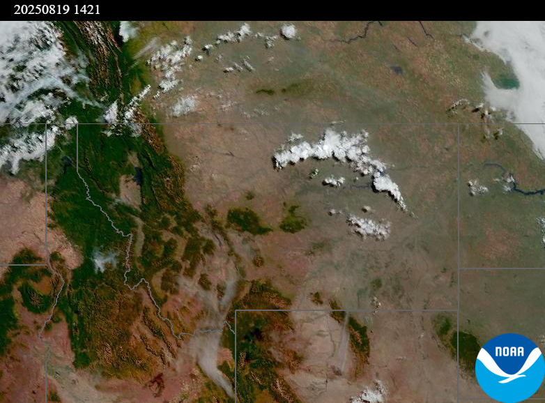
Source: NOAA
| Incident Name | State | Location | Acres | Containment |
|---|---|---|---|---|
| Rock Fire | Idaho | 5 miles southwest of Donnelly, ID | 2695 | 0% |
| Sunset Fire | Idaho | 26 Miles N of Coeur d'Alene, ID | 3208 | 0% |
| Lightning Creek Fire | Idaho | 9 miles north of Clark Fork, ID | 2515 | 25% |
| Mire | Idaho | Approximately 22 miles West/NW of Powell Idaho | 100 | 0% |
| Island Creek | Idaho | Near Sob Point on the Moose Creek Ranger District. | 1000 | 5% |
| Rush | Idaho | 57 Miles NW of McCall, Idaho - Frank Church-River of No Return Wilderness | 7539 | 90% |
| Big Bear | Idaho | 59 Miles NE of McCall, Idaho - Frank Church-River of No Return Wilderness | 15217 | 70% |
| Elkhorn Fire | Idaho | Krassel Ranger District, Payette National Forest | 26048 | 0% |
| Shingle | Idaho | NA | 100 | 55% |
| Cedar Fire | Idaho | approximately 4 miles northeast of Clyde | 898 | 86% |
| Elkhorn Fire | Idaho | 45 Miles E of Challis, ID | 953 | 0% |
| Cloudrest | Montana | 15 Miles northwest of Virginia City, MT | 1183 | 0% |
| Bivens Creek | Montana | 15 Miles North of Virginia City, MT | 2060 | 0% |
| Windy Rock Fire | Montana | 15 Miles NE of Drummond, MT | 848 | 0% |
| Knowles Fire | Montana | 11 Miles E of Plains, MT | 275 | 0% |
| Horn Fire | Montana | Madison County, between Cliff Lake and Highway 87 | 2800 | 75% |
| McAllister Fire | Montana | Madison County, 3 miles south of Norris, 3 miles north of Ennis Lake | 3500 | 30% |
| Gill Gulch Fire | Montana | 7 Miles south of Lincoln, MT | 34 | 35% |
| Butte Creek | Oregon | 2 miles west of Simnasho, Oregon | 2079 | 85% |
| Hagelstein Fire | Oregon | 14 miles north of Klamath Falls, Oregon | 669 | 75% |
| Elk Fire | Oregon | 7 miles SW of Beatty, Oregon | 2637 | 95% |
| Crescent Road | Washington | 7 Miles N of Reardan, WA | 883 | 47% |
| Pomas Fire | Washington | Approximately 36 miles northwest of Entiat, WA | 3533 | 0% |
| Bear Gulch Fire | Washington | 10 Miles Northwest of Hoodsport, WA | 8368 | 5% |
| Bear Creek II | Washington | 18 miles N of Keller, WA | 267 | 70% |
| Castle Rock Fire | Washington | 6 Miles SE of Colville, WA | 58 | 99% |
Tags: Smoke Forecast 2025