
Smoke Forecast for Monday, August 18, 2025 9:30 AM
Current Conditions
Numerous regional wildfires received rain over the weekend, moderating fire behavior and reducing surface smoke.
On Sunday, the Knowles fire burning near Paradise, Montana, was active. It has burned around 150 acres, and it will continue to send smoke into portions of Lake County. The Island Creek fire, burning in central Idaho, exhibited active fire behavior on Sunday, occasionally sending smoke into Ravalli County. Expect similar behavior over the next 48-hours thanks to moderating temperatures and westerly transport winds. Two wildfires burning in the Tobacco Root Mountain have grown quickly over the last 48-hours. Expect some downstream impacts in places like Bozeman and Livingston in the coming days. The Red Canyon fire, burning in north central Wyoming, has grown to 91,581 acres. It will continue sending some surface smoke into sections of southeast Montana. Rain fell over the weekend on the Windy Rock fire, which has burned 848 acres in Powell County just south of Mannix, Montana. Expect additional smoke impacts in places like the Helena Valley from this fire.
At 8:00 AM Monday, Sleeping Giant’s air quality is Moderate.
By Tuesday evening, the HRRR smoke model shows light surface smoke from regional wildfires impacting much of the state.
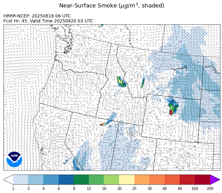
Source: HRRR-smoke
Forecast
Montana will be under the influence of a southwesterly flow again on Monday. It will send scattered showers and thunderstorms across the state, producing gusty winds and heavy rain. Wetting rains fell on several wildfires across the northern Rockies over the weekend, helping to temporarily moderate fire behavior and limit smoke production.
A ridge of high pressure builds across Montana on Tuesday. Warmer air, lower humidity, and gusty afternoon winds will produce more active fire behavior and increased smoke, particularly for communities adjacent to wildfires. The Knowles fire burning near Paradise, Montana will continue to send smoke into southern Lake County in this pattern. Portions of Ravalli County lie just east of the Island Creek fire in central Idaho. Expect some smoke impacts in the coming days from this blaze. Communities downstream of the Windy Rock fire, including much of the Helena Valley, will see smoke transported from this fire in the next 48-hours.
A dry cold front will move over the region on Wednesday. It will provide gusty westerly winds and a slight cool down. Behind the front, temperatures will be closer to average by Thursday. Most forecast models depict little to no precipitation over the next seven days. Fuel moistures will gradually dry under this pattern, allowing existing wildfires to expand while setting the stage for the potential for new starts. Stay tuned!
Conditions can change quickly as weather could stimulate active fires and the likelihood of new starts increases. Please keep track of concentrations at todaysair.mtdeq.us or the Fire and Smoke Map.
Monday morning’s satellite shows clouds associated with some light precipitation moving across southwest Montana.
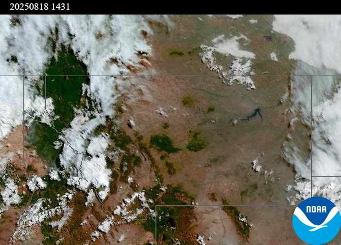
Source: NOAA
| Incident Name | State | Location | Acres | Containment |
|---|---|---|---|---|
| Rock Fire | Idaho | 5 miles southwest of Donnelly, ID | 2673 | 0% |
| Sunset Fire | Idaho | 26 Miles N of Coeur d'Alene, ID | 3199 | 0% |
| Lightning Creek Fire | Idaho | 9 miles north of Clark Fork, ID | 2515 | 25% |
| Mire | Idaho | Approximately 22 miles West/NW of Powell Idaho | 100 | 0% |
| Island Creek | Idaho | Near Sob Point on the Moose Creek Ranger District. | 1000 | 5% |
| Rush | Idaho | 57 Miles NW of McCall, Idaho - Frank Church-River of No Return Wilderness | 7539 | 90% |
| Big Bear | Idaho | 59 Miles NE of McCall, Idaho - Frank Church-River of No Return Wilderness | 15217 | 70% |
| Elkhorn Fire | Idaho | Krassel Ranger District, Payette National Forest | 26048 | 0% |
| Shingle | Idaho | NA | 100 | 55% |
| Elkhorn Fire | Idaho | 45 Miles E of Challis, ID | 953 | 0% |
| Cedar Fire | Idaho | approximately 4 miles northeast of Clyde | 898 | 86% |
| Bivens Creek | Montana | 15 Miles N of Virginia City, MT | 1932 | 0% |
| Cloudrest | Montana | 15 Miles NW of Virginia City, MT | 1156 | 0% |
| Windy Rock Fire | Montana | 15 Miles NE of Drummond, MT | 848 | 0% |
| Horn Fire | Montana | Madison County, between Cliff Lake and Highway 87 | 2800 | 50% |
| Summer Springs Fire | Montana | 13 miles SE of Custer, Montana | 2568 | 95% |
| Gill Gulch Fire | Montana | 7 Miles south of Lincoln, MT | 34 | 35% |
| Butte Creek | Oregon | 2 miles west of Simnasho, Oregon | 2079 | 85% |
| Hagelstein Fire | Oregon | 14 miles north of Klamath Falls, Oregon | 669 | 75% |
| Elk Fire | Oregon | 7 miles SW of Beatty, Oregon | 2637 | 95% |
| Bear Gulch Fire | Washington | 10 Miles Northwest of Hoodsport, WA | 8368 | 5% |
| Crescent Road | Washington | 7 Miles N of Reardan, WA | 883 | 27% |
| Pomas Fire | Washington | Approximately 36 miles northwest of Entiat, WA | 3533 | 0% |
| Bear Creek | Washington | 18 miles N of Keller, WA | 267 | 70% |
| Castle Rock Fire | Washington | 6 Miles SE of Colville, WA | 58 | 99% |
Tags: Smoke Forecast 2025