
Smoke Forecast for Friday, August 15, 2025 9:15 AM
Current Conditions
Wildfire activity has significantly increased across parts of Idaho and Montana over the last 48-hours.
Warm temperatures and breezy afternoon winds will lead to additional fire growth and increased smoke production on many regional wildfires again on Friday. New fires have popped up across Montana this week. The Cloudrest fire burning in Madison County and the Windy Rock fire north of Garrison Junction in Powell County exhibited active fire behavior on Thursday. These blazes will send smoke into communities downwind of them in the next 48-hours. The Rock fire, burning near Donnelly, Idaho, started on Wednesday, and grew significantly Thursday. It is up to 2,335 acres. It will transport smoke into southwest Montana over the next 48-hours. The Elkhorn fire, just east of the Rock fire in central Idaho, started on Wednesday, and has burned 953 acres. The Lightning Creek fire just east of Sandpoint, Idaho, has grown to 2,482 acres. It is 10% contained. The most active fire burning in the Idaho panhandle on Thursday was the Sunset fire. It will continue to send smoke into Lincoln and Flathead Counties. It has already burned 1,600 acres on the west side of Lake Pend Oreille. Expect similar fire behavior again on Friday.
At 9:00 AM Friday, Columbia Falls and Great Falls’ air quality is Moderate.
By Friday evening, the HRRR smoke model shows surface smoke from regional wildfires impacting parts of the state.
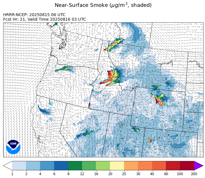
Source: HRRR-smoke
Forecast
Friday will feature a zonal, westerly flow across the state. Seasonably warm air, gusty afternoon winds, and active regional wildfires will combine to transport smoke into parts of the state. The Rock, Elkhorn, and Sunset fire burning in Idaho were active on Thursday. Smoke from these blazes will be transported east into Montana, particularly the western third of the state. Additionally, numerous new fires have started in Montana in recent days. The Cloudrest fire burning in Madison County and the Windy Rock fire north of Garrison Junction in Powell County exhibited active fire behavior on Thursday. These blazes will send smoke into communities downwind of them in the next 48-hours.
A southwesterly flow will develop on Saturday. It will pump monsoonal moisture into the state and increase our chances for showers and thunderstorms. Low pressure off the West Coast and a sprawling area of high pressure to our east will maintain the southwesterly flow through early next week. This pattern will provide seasonably warm temperatures and daily chances for afternoon and evening thunderstorms.
Most long-range models show a ridge of high pressure building over the Northern Rockies by the end of next week. This tends to favor warmer than average temperatures and little to no precipitation. Expect the usual summer patterns to smoke behavior, with smoke draining and pooling overnight into communities adjacent to wildfires. Gusty afternoon winds will tend to produce more active fire behavior on many regional wildfires.
Conditions can change quickly as weather could stimulate active fires and the likelihood of new starts increases. Please keep track of concentrations at todaysair.mtdeq.us or the Fire and Smoke Map.
Friday morning’s satellite shows some smoke over the eastern half of Montana from numerous regional wildfires.
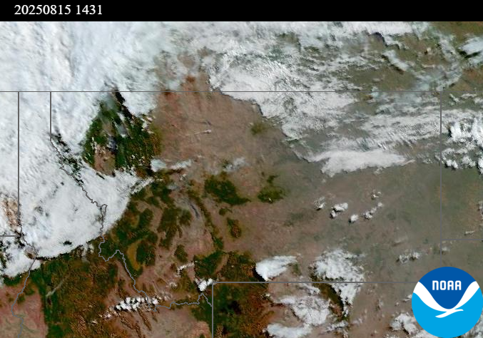
Source: NOAA
| Incident Name | State | Location | Acres | Containment |
|---|---|---|---|---|
| Rock Fire | Idaho | 5 miles SW of Donnelly Idaho | 2335 | 0% |
| Sunset Fire | Idaho | 26 Miles N of Coeur d'Alene, ID | 1600 | 0% |
| Lightning Creek Fire | Idaho | 9 miles north of Clark Fork, ID | 2482 | 10% |
| Rush | Idaho | 57 Miles NW of McCall, Idaho - Frank Church-River of No Return Wilderness | 7539 | 90% |
| Big Bear | Idaho | 59 Miles NE of McCall, Idaho - Frank Church-River of No Return Wilderness | 15217 | 70% |
| Island Creek | Idaho | Near Sob Point on the Moose Creek Ranger District. | 658 | 5% |
| Shingle | Idaho | NA | 100 | 55% |
| Elkhorn Fire | Idaho | 45 Miles E of Challis, ID | 953 | 0% |
| Cedar Fire - Idaho | Idaho | approximately 4 miles northeast of Clyde | 898 | 86% |
| Summer Springs Fire | Montana | 13 miles SE of Custer, Montana | 2568 | 0% |
| Horn Fire | Montana | Madison County, between Cliff Lake and Highway 87 | 2261 | 0% |
| Gill Gulch Fire | Montana | 7 Miles south of Lincoln, MT | 34 | 25% |
| Butte Creek | Oregon | 2 miles west of Simnasho, Oregon | 2079 | 85% |
| Hagelstein Fire | Oregon | 14 miles north of Klamath Falls, Oregon | 669 | 75% |
| Elk Fire | Oregon | 7 miles SW of Beatty, Oregon | 2637 | 95% |
| Bear Gulch Fire | Washington | 10 Miles Northwest of Hoodsport, WA | 8257 | 3% |
| Pomas Fire 2025 | Washington | Approximately 36 miles northwest of Entiat, WA | 3533 | 0% |
| Central Ferry | Washington | NA | 6,597 | 40% |
| Crescent Road | Washington | 7 Miles N of Reardan, WA | 779 | 0% |
| Bear Creek II | Washington | 18 miles N of Keller, WA | 267 | 70% |
| Castle Rock Fire | Washington | 6 Miles SE of Colville, WA | 58 | 99% |
Tags: Smoke Forecast 2025