
Smoke Forecast for Thursday, August 14, 2025 7:45 AM
Current Conditions
Critical fire weather conditions on Wednesday led to more active fire behavior and increased smoke production on numerous regional wildfires.
Warm temperatures and breezy afternoon winds will lead to additional fire growth and increased smoke production on many regional wildfires Thursday. The Rock fire, burning near Donnelly, Idaho, started on Wednesday, and grew significantly. It is up to 1,871 acres. It will send smoke into southwest Montana again on Thursday. An unnamed fire just east of the Rock fire in central Idaho started on Wednesday, exhibiting active fire behavior. The Lightning Creek fire just east of Sandpoint, Idaho, has grown to 2,482 acres. It is 10% contained. It was very active on Wednesday, sending smoke into Lincoln and Flathead Counties. Expect similar fire behavior again on Thursday. In southeast Montana, the Mission Butte, Pony Creek, and Summer Springs wildfires started in the last 48-hours thanks to critical fire weather conditions. They will remain active in the coming days.
At 7:00 AM Thursday, Columbia Falls, Frenchtown, Dillon, Seeley Lake, and Miles City's air quality is Moderate.
By Friday evening, the HRRR smoke model shows surface smoke from regional wildfires impacting parts of the state.
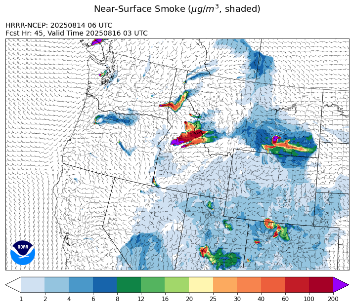
Source: HRRR-smoke
Forecast
Warm temperatures, low humidity, and gusty afternoon winds will produce active fire behavior once again on Thursday. Fire behavior in Washington, Idaho, and Montana perked up on Wednesday thanks to these same conditions. Smoke models are showing westerly transport winds continuing Thursday and the western third of Montana will see increased smoke because of fires burning upstream in Idaho and Washington. A trio of active fires in southeast Montana will keep skies hazy and lead to deteriorating air quality at times. By Thursday evening, an easterly flow could send increasing amounts of smoke into Billings.
By late Friday, the flow becomes more southwesterly. This will bring increasing monsoonal moisture to the region, providing good chances for rain over the panhandle of Idaho and northwest Montana where a couple of active wildfires continue burning. Unfortunately, most of Montana will miss out on this precipitation. Expect the usual diurnal influences to smoke production over the next few days. Smoke will tend to drain and pool into the valleys overnight, leading to deteriorating air quality. As the winds pick up around midday, fire behavior will increase as air quality will gradually improve.
Expect seasonably warm temperatures around the state by this weekend. The southwesterly flow will continue to bring monsoonal moisture into the state, producing afternoon and evening thunderstorm chances, primarily over the mountains. However, there is little widespread precipitation in the forecast over the next several days. Fire behavior on Idaho and Montana’s wildfires will remain active in this pattern, with increased smoke production for communities downwind of these blazes. Stay tuned!
Conditions can change quickly as weather could stimulate active fires and the likelihood of new starts increases. Please keep track of concentrations at todaysair.mtdeq.us or the Fire and Smoke Map.
Wednesday evening’s satellite shows numerous regional wildfires across Washington, Idaho, and Montana becoming more active thanks to critical fire weather conditions.
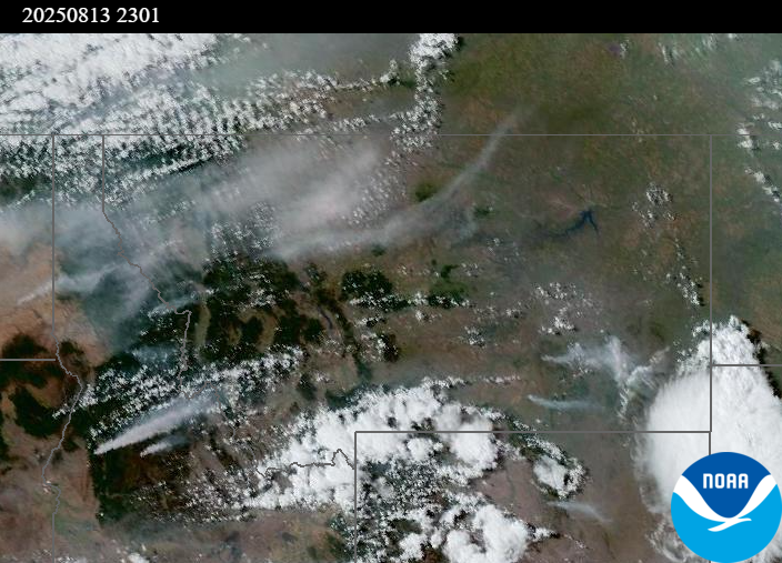
Source: NOAA
| Incident Name | State | Location | Acres | Containment |
|---|---|---|---|---|
| Lightning Creek Fire | Idaho | 9 miles north of Clark Fork, ID | 2482 | 10% |
| Island Creek | Idaho | Near Sob Point on the Moose Creek Ranger District. | 658 | 5% |
| Rush | Idaho | 57 Miles NW of McCall, Idaho - Frank Church-River of No Return Wilderness | 7392 | 90% |
| Big Bear | Idaho | 59 Miles NE of McCall, Idaho - Frank Church-River of No Return Wilderness | 14935 | 70% |
| Elkhorn Fire | Idaho | Krassel Ranger District, Payette National Forest | 26048 | 0% |
| Shingle | Idaho | NA | 100 | 55% |
| Cedar Fire - | Idaho | approximately 4 miles northeast of Clyde | 732 | 22% |
| Butte Creek | Oregon | 2 miles west of Simnasho, Oregon | 2079 | 85% |
| Hagelstein Fire | Oregon | 14 miles north of Klamath Falls, Oregon | 669 | 75% |
| Elk Fire | Oregon | 7 miles SW of Beatty, Oregon | 2637 | 95% |
| Bear Creek II | Washington | 18 miles N of Keller, WA | 267 | 70% |
| Bear Gulch Fire | Washington | 10 Miles Northwest of Hoodsport, WA | 8257 | 3% |
| Pomas Fire | Washington | Approximately 36 miles northwest of Entiat, WA | 3473 | 0% |
| Castle Rock Fire | Washington | 6 Miles SE of Colville, WA | 58 | 99% |
Tags: Smoke Forecast 2025