
Smoke Forecast for Wednesday, August 13, 2025 9:30 AM
Current Conditions
Gusty winds, low humidity, and unseasonably warm temperatures will produce critical fire weather conditions around the state on Wednesday.
Warmer temperatures and breezy afternoon winds will lead to additional fire growth and increased smoke production on many regional wildfires Wednesday. The Lightning Creek fire just east of Sandpoint, Idaho, has grown to 2,461 acres. It is 10% contained. It will send some smoke into Lincoln and Flathead Counties in the coming days. The Big Bear and Rush fires continue to burn in the Bitterroot Range of central Idaho, just southwest of the Bitterroot Valley. The Big Bear fire has grown to 14,935 acres and is 70% contained, while the Rush fire is up to 7,392 acres and is 90% contained. The South Meadow Creek fire burning west of Yaak in Lincoln County was first reported on Tuesday.
At 9:00 AM Wednesday, Libby, Columbia Falls, and Great Falls’ air quality is Moderate.
By Thursday evening, the HRRR smoke model shows light surface smoke from regional wildfires impacting the western third of Montana.
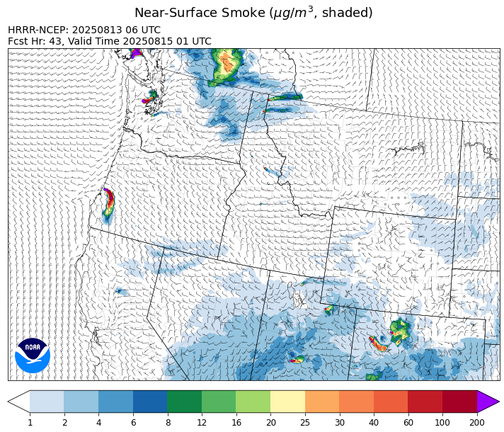
Source: HRRR-smoke
Forecast
A dry cold front will march across the state starting Wednesday afternoon. The biggest impact to our weather will be in the form of gusty westerly winds. Gusts between 30 and 40 miles per hour will be common. The combination of gusty winds, low humidity, and unseasonably warm air will create critical fire weather conditions. The Island Creek fire, burning in central Idaho just west of the Bitterroot Valley, displayed more active fire behavior on Tuesday. Westerly transport winds will send smoke into Ravalli County at times over the next 48-hours. Additionally, the Lightning Creek fire, burning near Sandpoint, Idaho, and the South Meadow Creek fire burning near Yaak, will keep some surface smoke over Lincoln and Flathead Counties in the coming days.
A westerly, zonal flow will linger into Thursday and Friday across the state. This will produce seasonably warm temperatures and gusty afternoon winds. The dry and breezy pattern will promote more active fire behavior and increased smoke production on regional wildfires. Large, active fires continue to burn over western Washington and British Columbia. Smoke models continue to indicate that some of this smoke will be transported into the Treasure State between Thursday and Friday.
By Friday night and Saturday, a system will move across the Northern Rockies providing beneficial rainfall. However, the bulk of this precipitation looks to impact northwest Montana. The precipitation should help to moderate fire behavior and limit smoke production on the Lightning Creek and South Meadow Creek fires. Stay tuned!
Conditions can change quickly as weather could stimulate active fires and the likelihood of new starts increases. Please keep track of concentrations at todaysair.mtdeq.us or the Fire and Smoke Map.
Wednesday morning’s satellite shows light smoke being transported east into northern Idaho from regional wildfires.
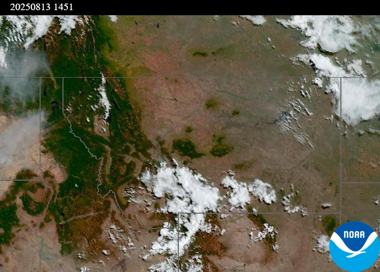
Source: NOAA
| Incident Name | State | Location | Acres | Containment |
|---|---|---|---|---|
| Lightning Creek Fire | Idaho | 9 miles north of Clark Fork, ID | 2461 | 10% |
| Island Creek | Idaho | Near Sob Point on the Moose Creek Ranger District. | 653 | NA |
| Rush | Idaho | 57 Miles NW of McCall, Idaho - Frank Church-River of No Return Wilderness | 7392 | 90% |
| Big Bear | Idaho | 59 Miles NE of McCall, Idaho - Frank Church-River of No Return Wilderness | 14935 | 70% |
| Elkhorn Fire | Idaho | Krassel Ranger District, Payette National Forest | 26048 | NA |
| Shingle | Idaho | NA | 100 | NA |
| Post Fire | Idaho | North of US Highway 12, East of Mocus Point Trailhead | 144 | 94% |
| Cedar Fire | Idaho | approximately 4 miles northeast of Clyde | 732 | 22% |
| Gill Gulch Fire | Montana | 7 Miles south of Lincoln, MT | 34 | NA |
| Butte Creek | Oregon | 2 miles west of Simnasho, Oregon | 2079 | 85% |
| Hagelstein Fire | Oregon | 14 miles north of Klamath Falls, Oregon | 669 | 75% |
| Elk Fire | Oregon | 7 miles SW of Beatty, Oregon | 2637 | 95% |
| Bear Creek II | Washington | 18 miles N of Keller, WA | 267 | 32% |
| Bear Gulch Fire | Washington | 10 Miles Northwest of Hoodsport, WA | 6196 | 3% |
| Pomas Fire | Washington | Approximately 36 miles northwest of Entiat, WA | 3473 | NA |
| Castle Rock Fire | Washington | 6 Miles SE of Colville, WA | 58 | 99% |
Tags: Smoke Forecast 2025