
Smoke Forecast for Tuesday, August 12, 2025 9:30 AM
Current Conditions
Wildfire activity is beginning to pick up across the region thanks to moderating temperatures and gusty afternoon winds.
Warmer temperatures and breezy afternoon winds will lead to additional fire growth and increased smoke production on many regional wildfires Tuesday. The Lightning Creek fire just east of Sandpoint, Idaho, has grown to 2,461 acres. It is 0% contained. It will send some smoke into Lincoln and Flathead Counties in the coming days. The Big Bear and Rush fires continue to burn in the Bitterroot Range of central Idaho, just southwest of the Bitterroot Valley. The Big Bear fire has grown to 14,935 acres and is 70% contained, while the Rush fire is up to 7,392 acres and is 90% contained. The Big Bear fire exhibited more active fire behavior on Monday compared to previous days. Thanks to warm air, low humidity, and gusty winds, expect this trend to continue.
At 9:00 AM Tuesday, Libby's air quality is Moderate.
By Wednesday evening, the HRRR smoke model shows smoke from regional wildfires impacting the western third of Montana.
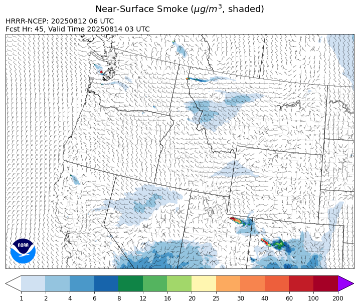
Source: HRRR-smoke
Forecast
Warm temperatures, gusty afternoon winds, and low humidity will lead to more active fire weather behavior across the region between Tuesday and Wednesday. Fuel moistures over much of southwest Montana remain seasonably dry and new fire starts are certainly a concern in this environment. Southwesterly transport winds will begin to bring light surface smoke from wildfires burning in central Idaho into portions of Ravalli and Beaverhead Counties. A shower or two is possible but most of this precipitation will remain along the Continental Divide and the Canadian border.
By Wednesday night and Thursday, a dry cold front will move across the Treasure State, bringing an end to the unseasonable warmth. However, afternoon winds will remain gusty, and this could provide more active fire behavior across the region.
Recent precipitation across northern Saskatchewan and Manitoba has moderated fire behavior and decreased smoke production. As a result, smoke from Canadian wildfires over the northern United States won't be nearly as impactful as it has been for much of the summer.
However, prrecipitation across Montana will be limited over the next seven days. This will likely be the longest dry stretch much of the state has endured this summer. The pattern will help to further dry out fuels and lead to more active fire behavior and increased smoke production on existing regional wildfires. Stay tuned!
Conditions can change quickly as weather could stimulate active fires and the likelihood of new starts increases. Please keep track of concentrations at todaysair.mtdeq.us or the Fire and Smoke Map.
Tuesday morning’s satellite shows a ribbon of elevated smoke over northeast Montana from Canadian wildfires.
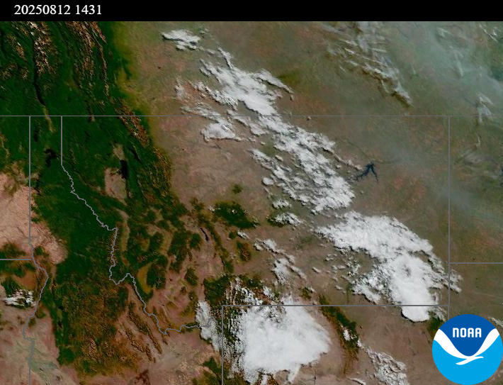
Source: NOAA
| Incident Name | State | Location | Acres | Containment |
|---|---|---|---|---|
| Lightning Creek Fire | Idaho | 9 miles north of Clark Fork, ID | 2461 | 0% |
| Island Creek | Idaho | Near Sob Point on the Moose Creek Ranger District. | 653 | 5% |
| Rush | Idaho | 57 Miles NW of McCall, Idaho - Frank Church-River of No Return Wilderness | 7392 | 90% |
| Big Bear | Idaho | 59 Miles NE of McCall, Idaho - Frank Church-River of No Return Wilderness | 14935 | 70% |
| Elkhorn Fire | Idaho | Krassel Ranger District, Payette National Forest | 26048 | 0% |
| Shingle | Idaho | NA | 100 | 55% |
| Post Fire | Idaho | North of US Highway 12, East of Mocus Point Trailhead | 144 | 94% |
| Cedar Fire | Idaho | approximately 4 miles northeast of Clyde | 732 | 22% |
| Gill Gulch Fire | Montana | 7 Miles south of Lincoln, MT | 34 | 0% |
| Butte Creek | Oregon | 2 miles west of Simnasho, Oregon | 2079 | 85% |
| Hagelstein Fire | Oregon | 14 miles north of Klamath Falls, Oregon | 669 | 75% |
| Elk Fire | Oregon | 7 miles SW of Beatty, Oregon | 2637 | 95% |
| Bear Creek II | Washington | 18 miles N of Keller, WA | 267 | 22% |
| Bear Gulch Fire | Washington | 10 Miles Northwest of Hoodsport, WA | 5777 | 3% |
| Pomas Fire | Washington | Approximately 36 miles northwest of Entiat, WA | 3473 | 0% |
| Castle Rock Fire | Washington | 6 Miles SE of Colville, WA | 58 | 99% |
| Hope Fire | Washington | Approximately 15 Miles north of Kettle Falls, WA and 5 miles southwest of Northport, WA | 8177 | 95% |
Tags: Smoke Forecast 2025