
Smoke Forecast for Monday, August 11, 2025 9:45 AM
Current Conditions
Air quality continues to improve over eastern Montana as Canadian wildfire smoke shifts east.
Despite the sunshine and warmer conditions, fire behavior on Sunday was subdued on most regional wildfires. The Lightning Creek fire just east of Sandpoint, Idaho, has grown to 2,432 acres. It is 0% contained. It will send some smoke into Lincoln and Flathead Counties in the coming days. The Big Bear and Rush fires continue to burn in the Bitterroot Range of central Idaho, just southwest of the Bitterroot Valley. The Big Bear fire has grown to 14,935 acres and is 70% contained, while the Rush fire is up to 7,392 acres and is 90% contained.
At 9:45 AM Monday, Sleeping Giant and Great Falls’ air quality is Moderate.
By Tuesday evening, the HRRR smoke model shows surface smoke from Canadian wildfires impacting the eastern third of Montana. Smoke from the Lightning Creek fire can be seen drifting into northwest Montana.
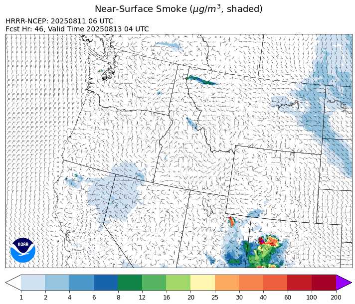
Source: HRRR-smoke
Forecast
High pressure will bring another sunny and seasonably warm day to Montana on Monday. Smoke models continue to advertise some smoke from the Lightning Creek fire, burning in the Idaho panhandle, pushing into Lincoln and Flathead Counties at times. Wildfire activity over Manitoba and Saskatchewan has moderated some of late thanks to recent precipitation. However, a northerly flow behind a weak front will bring some light surface smoke to the eastern half of Montana by Monday night and Tuesday from Canadian wildfires.
Unseasonably warm air returns to the Treasure State both Tuesday and Wednesday. Highs will climb well into the 80s and 90s over most valleys. The combination of warm temperatures, low humidity, and gusty winds will produce elevated fire weather concerns. The pattern will likely produce more active fire behavior and increased smoke production on most regional blazes.
Unlike much of the summer, precipitation will be limited across the state over the next week. Fuel moistures will gradually cure and dry out, increasing the risk for new wildfire starts. A southwesterly flow develops by Friday and into the weekend. This will raise humidity levels and introduce chances for showers and scattered thunderstorms. Stay tuned!
Conditions can change quickly as weather could stimulate active fires and the likelihood of new starts increases. Please keep track of concentrations at todaysair.mtdeq.us or the Fire and Smoke Map.
Monday morning’s satellite shows some light smoke over eastern Montana from Canadian wildfires.
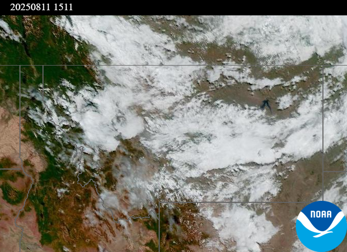
Source: NOAA
| Incident Name | State | Location | Acres | Containment |
|---|---|---|---|---|
| Lightning Creek Fire | Idaho | 9 miles north of Clark Fork, ID | 2432 | 0% |
| Island Creek | Idaho | Near Sob Point on the Moose Creek Ranger District. | 652 | 0% |
| Rush | Idaho | 57 Miles NW of McCall, Idaho - Frank Church-River of No Return Wilderness | 7392 | 90% |
| Big Bear | Idaho | 59 Miles NE of McCall, Idaho - Frank Church-River of No Return Wilderness | 14935 | 70% |
| Elkhorn Fire | Idaho | Krassel Ranger District, Payette National Forest | 26048 | 0% |
| Shingle | Idaho | NA | 100 | 55% |
| Post Fire | Idaho | North of US Highway 12, East of Mocus Point Trailhead | 144 | 94% |
| Cedar Fire | Idaho | approximately 4 miles northeast of Clyde | 732 | 56% |
| Gill Gulch Fire | Montana | 7 Miles south of Lincoln, MT | 34 | 0% |
| Dominic Point Fire | Montana | NA | 31 | 90% |
| Butte Creek | Oregon | 2 miles west of Simnasho, Oregon | 2079 | 85% |
| Hagelstein Fire | Oregon | 14 miles north of Klamath Falls, Oregon | 669 | 75% |
| Elk Fire | Oregon | 7 miles SW of Beatty, Oregon | 2637 | 95% |
| Bear Gulch Fire | Washington | 10 Miles Northwest of Hoodsport, WA | 5652 | 3% |
| Bear Creek II | Washington | 18 miles N of Keller, WA | 260 | 0% |
| Pomas Fire | Washington | Approximately 36 miles northwest of Entiat, WA | 3473 | 0% |
| Castle Rock Fire | Washington | 6 Miles SE of Colville, WA | 58 | 99% |
| Hope Fire | Washington | Approximately 15 Miles north of Kettle Falls, WA and 5 miles southwest of Northport, WA | 8177 | 95% |
Tags: Smoke Forecast 2025