
Smoke Forecast for Friday, August 8, 2025 8:30 AM
Current Conditions
Wildfires upwind of Montana in Idaho will continue to send some light smoke into the state, particularly the western third.
Rain fell on many of the Idaho wildfires on Thursday, reducing smoke and easing fire behavior. The Lightning Creek fire just east of Sandpoint, Idaho, has grown to 2,427 acres. It is 0% contained. It will send some smoke into Lincoln and Flathead Counties in the coming days. The Big Bear and Rush fires continue to burn in the Bitterroot Range of central Idaho, just southwest of the Bitterroot Valley. The Big Bear fire has grown to 14,935 acres and is 70% contained, while the Rush fire is up to 7,392 acres and is 90% contained.
At 8:00 AM Friday, Great Falls’ air quality is Moderate.
By Saturday evening, the HRRR smoke model shows surface smoke from Canadian wildfires impacting the eastern half of Montana.
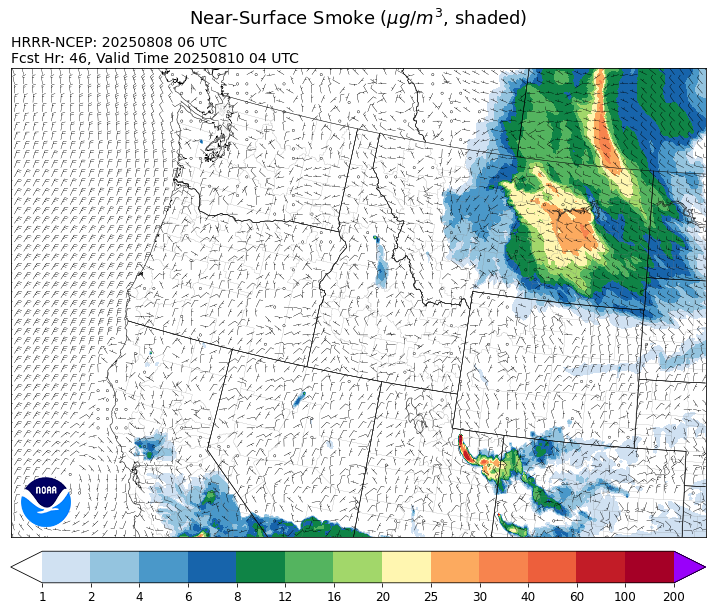
Source: HRRR-smoke
Forecast
Low pressure brought widespread rain and storms to the region on Thursday, including much of Idaho where several active fires are burning. It helped to moderate fire behavior and reduce smoke production. Precipitation will wrap around the departing storm and bring additional precipitation to parts of the state on Friday. Behind this system, expect breezy conditions and unseasonably cool temperatures to end the week.
A northwesterly flow of air will accompany an area of low pressure on Saturday. The low will drag down some surface smoke from wildfires burning across northern Saskatchewan and Manitoba. Expect some impacts to air quality because of this pattern. Smoke models indicate that this surface smoke will impact the eastern half of the state. However, by Sunday and Monday, much of this smoke will drift east into the Dakotas and Minnesota, exiting Montana.
High pressure will build over the state from west to east this weekend. It will provide more seasonable temperatures with highs climbing well into the 80s and 90s by early next week. This will lead to more active fire behavior and increased smoke production. Expect some smoke impacts in communities downwind of the Lightning Creek, Island Creek, and Big Bear fires at times, particularly in northwest Montana and in the Bitterroot Valley. Thanks to recent precipitation, fuel moistures remain unseasonably wet across the region. However, there are still pockets in southwest Montana where fuel moistures are closer to normal and may be more receptive to fire in the coming days. Stay tuned!
Conditions can change quickly as weather could stimulate active fires and the likelihood of new starts increases. Please keep track of concentrations at todaysair.mtdeq.us or the Fire and Smoke Map.
Friday morning’s satellite shows widespread clouds across Montana from a departing area of low pressure.
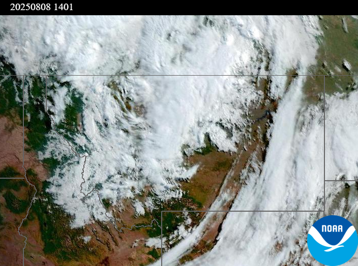
Source: NOAA
| Incident Name | State | Location | Acres | Containment |
|---|---|---|---|---|
| Island Creek | Idaho | Near Sob Point on the Moose Creek Ranger District. | 612 | NA |
| Rush | Idaho | 57 Miles NW of McCall, Idaho - Frank Church-River of No Return Wilderness | 7392 | 90% |
| Big Bear | Idaho | 59 Miles NE of McCall, Idaho - Frank Church-River of No Return Wilderness | 14935 | 70% |
| Lightning Creek Fire | Idaho | 9 miles north of Clark Fork, ID | 2427 | 0% |
| Elkhorn Fire | Idaho | Krassel Ranger District, Payette National Forest | 26048 | NA |
| Shingle | Idaho | NA | 100 | NA |
| Post Fire | Idaho | North of US Highway 12, East of Mocus Point Trailhead | 144 | 94% |
| Cedar Fire | Idaho | approximately 4 miles northeast of Clyde | 732 | 22% |
| Gill Gulch Fire | Montana | 7 Miles south of Lincoln, MT | 27 | NA |
| Dominic Point Fire | Montana | NA | 31 | 90% |
| Butte Creek | Oregon | 2 miles west of Simnasho, Oregon | 2079 | 85% |
| Hagelstein Fire | Oregon | 14 miles north of Klamath Falls, Oregon | 669 | 75% |
| Elk Fire | Oregon | 7 miles SW of Beatty, Oregon | 2637 | 95% |
| Pomas Fire | Washington | Approximately 36 miles northwest of Entiat, WA | 3468 | NA |
| Bear Gulch Fire | Washington | 10 Miles Northwest of Hoodsport, WA | 5515 | 3% |
| Kinkaid Creek | Washington | 8 Miles N of Nespelem, WA | 254 | 89% |
| Bear Creek II | Washington | 18 miles N of Keller, WA | 260 | 0% |
| Castle Rock Fire | Washington | 6 Miles SE of Colville, WA | 58 | 50% |
| Hope Fire | Washington | Approximately 15 Miles north of Kettle Falls, WA and 5 miles southwest of Northport, WA | 8177 | 95% |
Tags: Smoke Forecast 2025