
Smoke Forecast for Friday, August 1, 2025 10:00 AM
Current Conditions
Recent rain has moderated fire behavior and reduced smoke production on regional wildfires. However, there are still handful of small wildfires burning in the state.
The Sucker Creek fire started on Sunday and grew rapidly because of gusty outflow winds from thunderstorms. It is located 2 miles northwest of Lincoln and has burned 80 acres and is 10% contained. Firefighters have made good progress on the Observation Point fire burning just outside Hamilton. It is up to 105 acres and is now 87% contained. The Big Bear and Rush fires continue to burn in the Bitterroot Range of central Idaho, just southwest of the Bitterroot Valley. The Big Bear fire has grown to 14,935 acres and is 50% contained while the Rush fire is up to 7,382 acres and is 50% contained. Recent precipitation, cooler temperatures, and higher humidity continue to limit smoke production on these blazes.
At 9:00 AM Friday, Libby, Great Falls, Lewistown, Miles City, and Sidney's air quality is Moderate.
By Saturday afternoon, the HRRR smoke model shows some light surface smoke over eastern Montana from wildfires burning over the Four Corners region and Canada.
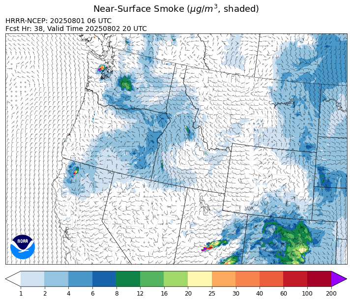
Source: HRRR-smoke
Forecast
A southerly flow will continue to pump unusually moist air into the Treasure State again on Friday. A series of weak disturbances will drift over the Northern Rockies and interact with this airmass. This will set the stage for another round showers and thunderstorms starting Friday afternoon. The southerly flow will send some light surface smoke into the eastern third of the state from active wildfires burning in Utah and Arizona. The main threats from the storms will be from frequent lightning, small hail, and gusty winds.
The pattern will bring another round of rain and storms to Montana again on Saturday. However, most of this precipitation will be focused across northwest Montana, including Lincoln, Flathead, and Lake Counties. Friday and Saturday’s precipitation should help to moderate fire behavior and limit smoke production on regional wildfires.
A ridge of high pressure will build over the state on Sunday, bringing a reprieve from the widespread afternoon thunderstorms. An area of low pressure moves inland late on Sunday along the West Coast. This will produce widely scattered thunderstorms across the Treasure State by Monday afternoon. The recent precipitation has kept fuel moistures anomalously wet across much of the state, reducing the risk for new wildfire starts. However, parts of southwest Montana have missed out on the recent rainfall and fuel moistures in this part of the state are closer to average and more receptive to new fires and fire growth. Stay tuned!
Conditions can change quickly as weather could stimulate active fires and the likelihood of new starts increases. Please keep track of concentrations at todaysair.mtdeq.us or the Fire and Smoke Map.
Friday morning’s satellite reveals some light smoke over eastern Montana from regional wildfires.
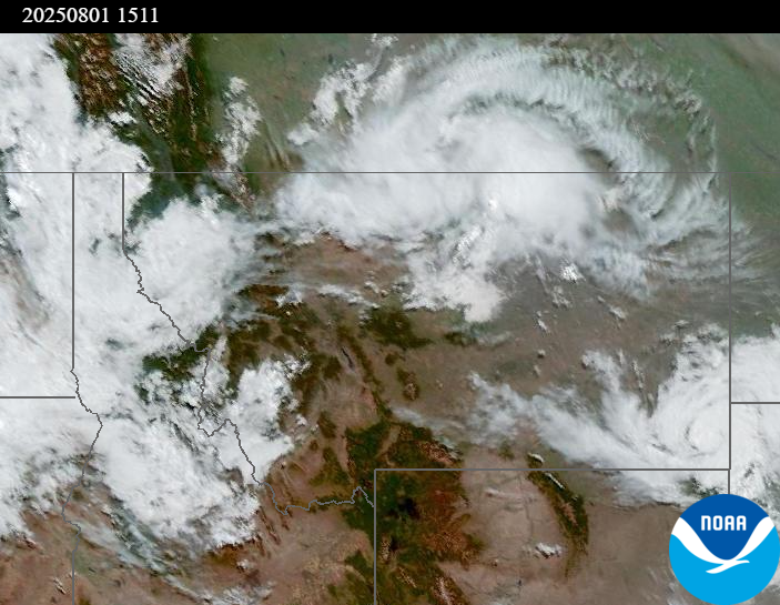
Source: NOAA
| Incident Name | State | Location | Acres | Containment |
|---|---|---|---|---|
| Rush | Idaho | 57 Miles NW of McCall, Idaho - Frank Church-River of No Return Wilderness | 7382 | 50% |
| Big Bear | Idaho | 59 Miles NE of McCall, Idaho - Frank Church-River of No Return Wilderness | 14935 | 50% |
| Shingle | Idaho | NA | 100 | NA |
| Post Fire | Idaho | NA | NA | NA |
| Cedar Fire | Idaho | approximately 4 miles northeast of Clyde | 219 | 0% |
| Sucker Creek Fire | Montana | 2 miles northwest of Lincoln, Montana | 80 | 10% |
| Green Mountain Fire & Garnet Fire | Montana | NA | NA | NA |
| Dominic Point Fire | Montana | NA | 31 | 0% |
| Observation Point Fire | Montana | Lost Horse Canyon, 10.5 miles south of Hamilton, MT | 105 | 87% |
| Butte Creek | Oregon | 2 miles west of Simnasho, Oregon | 2079 | 85% |
| Hagelstein Fire | Oregon | 14 miles north of Klamath Falls, Oregon | 669 | 75% |
| Elk Fire | Oregon | 7 miles SW of Beatty, Oregon | 2637 | 95% |
| Bear Gulch Fire | Washington | 10 Miles Northwest of Hoodsport, WA | 3055 | 3% |
| Burdoin Fire | Washington | 2.5 miles east of White Salmon | 10675 | 90% |
| Hope Fire | Washington | Approximately 15 Miles north of Kettle Falls, WA and 5 miles southwest of Northport, WA | 8177 | 90% |
| Pomas Fire | Washington | Approximately 36 miles northwest of Entiat, WA | 3458 | NA |
Tags: Smoke Forecast 2025