
Smoke Forecast for Thursday, August 1, 2024 9:30 AM
Current Conditions
High pressure continues to strengthen over the Northern Rockies Thursday. Much of Montana is enjoying a break from the smoke and haze from earlier in the week.
A good wetting rain fell on the Northern Rockies Tuesday, easing fire behavior and temporarily reducing smoke production. However, upstream of Montana, there are still several large active wildfires burning. In Oregon alone, there are 5 active wildfires over 100,000 acres in size that will continue to generate smoke over the Pacific Northwest and Northern Rockies for the foreseeable future.
At 9:00 AM Thursday, Great Falls, Lewistown, Sidney, and Broadus were enduring Moderate air quality.
Thursday morning’s satellite shows some smoke along the High Line, with abundant smoke in parts of Oregon, Idaho, and Washington.
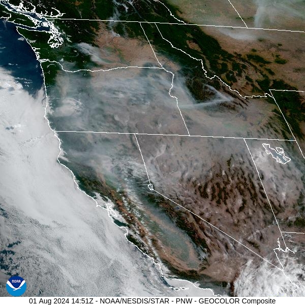
Source: NOAA
Forecast
High pressure will gradually strengthen over Montana Thursday and Friday. It will generate unseasonably warm temperatures and low relative humidity values. Southwest winds will allow smoke and haze from regional wildfires to return to the Treasure State. The skies will be noticeably smokier starting Friday.
Monsoonal moisture will return to Montana late Saturday and Sunday. The influx of moisture will bring the threat of heavy rainfall and thunderstorms. Some of these storms will generate gusty winds which could produce erratic fire behavior on existing wildfires. Considering much of the state west of the Continental Divide is in a worsening drought, any lightning has the potential to start new fires.
Next week should remain unsettled with monsoonal moisture remaining a theme. There will be chances for precipitation nearly every day, with the greatest rain totals over the higher terrain. The combination of rain and cooler temperatures should help temper wildfire activity over the Northern Rockies.
By Friday afternoon, the HRRR smoke model shows light to medium concentrations of smoke returning to Western Montana.
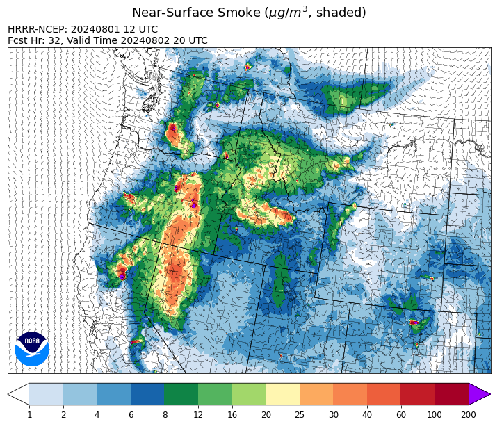
Source: HRRR Smoke
Conditions can change quickly as weather could stimulate active fires and the likelihood of new starts increases. Please keep track of concentrations at todaysair.mtdeq.us or the Fire and Smoke Map.
Current Wildfires
|
Incident |
State |
location |
acres |
containment |
|
Wolf Creek Fire - IDPAF |
Idaho |
5 miles west of Donnelly, ID |
909 |
0% |
|
Wapiti Fire - IDBOF |
Idaho |
2 miles southwest of Grandjean |
85 |
0% |
|
Bulltrout Fire - IDBOF |
Idaho |
15 MILE WNW OF STANLEY, ID |
292 |
15% |
|
Boulder Fire - IDBOF |
Idaho |
9 Miles southwest of Cascade, Idaho. |
554 |
7% |
|
Cliff Mountain - IDPAF |
Idaho |
25 Miles East of Joseph, Oregon |
1,101 |
0% |
|
Limepoint Fire - IDPAF |
Idaho |
8 miles NE of Oxbow Dam |
18,734 |
0% |
|
2024 Gwen Fire - IDIDS |
Idaho |
South of Juliaetta Idaho, about 30 miles outside Lewiston near State Highway 3 in Latah County |
28,805 |
65% |
|
Bench Lake Fire - IDSTF |
Idaho |
8 miles south of Stanley, Idaho |
2,595 |
85% |
|
Wye Fire - IDNCF |
Idaho |
Approximately four and a half miles northwest of Freeman Peak and seven miles northeast of the Moose Creek Airstrip |
3,500 |
NA |
|
Bluff Creek Complex - IDIPF |
Idaho |
The fires are burning along both sides of the Bluff Ridge, approximately 13 1/2 miles southeast of Avery, ID; five and a half miles west from Gold Creek Campground; and approximately two miles northwest of Junction Ridge. |
573 |
NA |
|
Oxbow Fire - IDPAF |
Idaho |
Near Oxbow dam in Hells Canyon |
6,000 |
NA |
|
Anchor - IDNCF |
Idaho |
About half way between Hanover Mountain and Square Mountain in the Gospel Hump Wilderness |
50 |
NA |
|
Shepp - IDNCF |
Idaho |
Approximately 30 miles Southwest of Elk City, Idaho |
75 |
NA |
|
Ace Butte - IDNCF |
Idaho |
Approximately 30 miles Southeast of Grangeville, Idaho |
75 |
NA |
|
Texas Fire - IDIDS |
Idaho |
Two miles East of Kendrick, ID |
1,582 |
90% |
|
Thunder Fire - IDSCF |
Idaho |
12 miles south, southwest of Salmon, ID |
2,474 |
34% |
|
Black Mountain - MTHLF |
Montana |
6 miles northwest of Lincoln. Mont. |
76 |
0% |
|
Miller Peak Fire - MTLNF |
Montana |
7 miles southeast of Missoula |
2,724 |
65% |
|
Muir Creek Fire - MTGNP |
Montana |
20 miles southeast of West Glacier, MT and east of the Middle Fork of the Flathead River |
30 |
0% |
|
Blacktail Canyon - MTBDF |
Montana |
4 miles southeast of Butte, MT |
80 |
95% |
|
Butler Creek Fire - MTMTS |
Montana |
5 miles northwest of Missoula |
284 |
100% |
|
Horse Gulch Fire - MTHLF |
Montana |
1/2 mile north of Canyon Ferry Dam near Helena, Montana |
15,167 |
100% |
|
Crazy Creek - OROCF |
Oregon |
Crazy Creek:16 miles north of Paulina, OR |
31,440 |
5% |
|
Adam Mountain - ORUPF |
Oregon |
Approximately 6 miles southeast of Dorena, Oregon |
9,997 |
7% |
|
Courtrock Fire - OR95S |
Oregon |
7.1 Miles S. of Monument, Oregon |
19,282 |
41% |
|
Durkee Fire - ORVAD |
Oregon |
1 mile west of Durkee, Oregon |
293,882 |
58% |
|
Microwave Tower Fire - OR95S |
Oregon |
5 miles WSW of Mosier, OR |
1,311 |
79% |
|
Red Fire - ORDEF |
Oregon |
Diamond Peak Wilderness |
428 |
0% |
|
Battle Mountain Complex - OR97S |
Oregon |
West and south of Ukiah, OR |
178,171 |
19% |
|
Whisky Creek Fire - ORMHF |
Oregon |
East fork of Herman Creek, 6 miles SE of Cascade Locks, OR |
891 |
0% |
|
Middle Fork Fire - ORCLP |
Oregon |
Middle Fork area, west of Crater Lake, Crater Lake National Park |
728 |
1% |
|
Diamond Complex - ORUPF |
Oregon |
18 miles southwest of Chemult, Oregon |
5,486 |
11% |
|
Homestead Complex - ORUPF |
Oregon |
Thirty miles northeast of Glide Oregon |
1,892 |
5% |
|
Lone Rock Fire - ORPRD |
Oregon |
Lonerock OR stretching to west of HWY 207 and south to HWY 19 |
137,221 |
80% |
|
Cottage Grove - Lane 1 - OR77S |
Oregon |
Approximately 16 miles SE of Springfield, OR |
2,112 |
7% |
|
Ore Fire - ORWIF |
Oregon |
7 Miles NE of Blue River, OR |
1,486 |
29% |
|
Telephone Fire - ORMAF |
Oregon |
16 miles north east of Burns, Oregon |
36,668 |
15% |
|
Falls Fire - ORMAF |
Oregon |
20 miles NW of Burns |
142,307 |
69% |
|
Cow Valley Fire - ORVAD |
Oregon |
West of Brogan and Northwest of Vale |
133,490 |
99% |
|
Badland Complex 2024 - ORVAD |
Oregon |
Baker County, Oregon |
54,615 |
69% |
|
Boulder Fire - ORMHF |
Oregon |
Approximately 26 miles SW of Dufur, OR. |
233 |
100% |
|
Pioneer - WASES |
Washington |
Approximate start 10 miles southeast of Stehekin, WA |
33,761 |
12% |
|
Easy Fire - WAOWF |
Washington |
North Cascades Hwy 20 Corridor, 17 air miles west of Mazama, WA |
528 |
0% |
|
Retreat - WASES |
Washington |
14 miles southwest of Naches, WA |
31,559 |
37% |
|
Black Canyon - WASES |
Washington |
10 Miles NW, Naches, WA |
9,211 |
99% |
|
Lower Granite Fire - WANES |
Washington |
Northeast of Pomeroy, WA |
14,482 |
50% |
|
Cougar Creek Fire - WASES |
Washington |
1 mile west of Hwy 129 and Grand Ronde river intersection |
17,602 |
29% |
|
Bridge Creek - WACOA |
Washington |
North of Bridge Creek, East of Elbow River |
3,950 |
50% |
|
Swawilla Fire - WACOA |
Washington |
North of Columbia River, East of Swawilla Basin, West of Hwy 21 |
48,970 |
60% |
|
Pincer Two Fire - WAMSF |
Washington |
Johanasburg Mountain. 1 Mile East of Mineral Park C.G. |
102 |
0% |
|
Big Horn Fire - WASES |
Washington |
7 miles SE of Bickleton Washington, and 7 miles N of Roosevelt, Washington |
51,569 |
100% |
Source: Inciweb
Tags: Smoke Forecast 2024