
Smoke Forecast for Friday, July 31, 2026 9:30 AM
Current Conditions
Smoke remains widespread over the state early Friday. However, outside of northwest Montana, air quality has improved compared to 24-hours ago across much of the state.
Thursday afternoon, the most active Montana wildfires were burning over the western third of the state. The Skillet Fire burning in Lincoln County, about 15 miles west of Olney grew again on Thursday. Smoke from this fire will impact communities along the Highway 93 corridor between Olney and Stryker, and the northern half of Glacier National Park. The Skillet Fire has now burned over 800 acres. The Silvertip Fire burning in the Bob Marshall Wilderness, between Choteau and Flathead Lake, was active again on Thursday. Smoke from this fire will continue to impact communities along the Hi-Line between Cut Bank and Chester. The Silvertip Fire has burned over 4,000 acres.
At 9:00 AM Friday, particulate levels in Havre, Butte, Great Falls, Hamilton, Helena, Lewistown, Sleeping Giant, Columbia Falls, Cut Bank, Dillon, Frenchtown, Libby, Missoula and Thompson Falls are Moderate.
By Saturday afternoon, the Rapid Refresh Forecast System (RRFS) smoke model shows strong winds pushing areas of near-surface smoke across the state from local and regional wildfires.
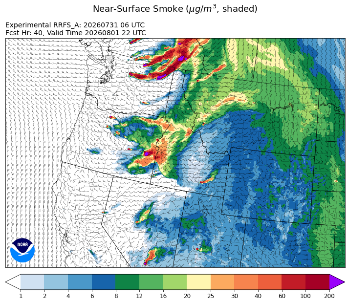
Source: HRRR-smoke
Forecast
Outside of northwest Montana, air quality has improved for most Montana communities compared to 24-hours ago. Some beneficial precipitation fell over parts of the state on Thursday. However, there was quite a bit of lightning with Thursday’s storms, and it will be interesting to see if there are any new fire starts in the coming days from this event. The upper-level ridge of high pressure lingers again on Friday, producing unseasonably warm air and low humidity.
The ridge begins to break down on Saturday as the southwesterly flow increases. Saturday will feature record warmth for many Montana communities with afternoon highs surging into the 90s and triple digits. The combination of very strong winds, low humidity, and hot temperatures will create elevated fire weather conditions for much of the state. A moisture-challenged front will sweep across the state, providing much cooler air starting Sunday and continuing the first half of next week.
Looking ahead, there is little reason for optimism in terms of fire weather conditions. Precipitation will be almost non-existent. The combination of drying fuels, seasonably warm air, low humidity, and gusty afternoon winds will contribute to active fire weather throughout much of the following week.
Conditions can change quickly as weather could stimulate active fires and the likelihood of new starts increases. Please keep track of concentrations at todaysair.mtdeq.us or the Fire and Smoke Map.
Widespread smoke remains visible across much of the state early Friday from regional wildfires.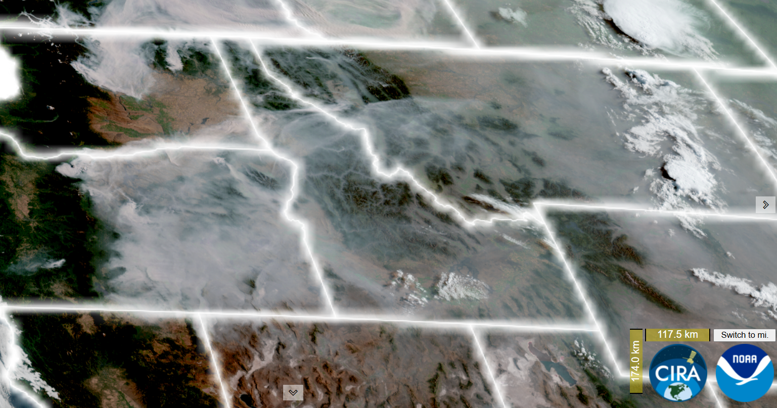
Source: NOAA
| Incident Name | State | Location | Acres | Containment |
|---|---|---|---|---|
| Tartar | Idaho | 21 Miles NW of Weiser, ID | 12208 | 57% |
| Upper Smith Fire | Idaho | Approx 20 miles northwest of Bonners Ferry, ID, up the Smith Creek Drainage | 1929 | 13% |
| Cascade | Idaho | 22 miles East of Lowell, Idaho | 430 | NA |
| Chimney Fire | Idaho | 9 miles northwest of Fairfield, ID | 6521 | 80% |
| Claremont Fire | Idaho | 1 mile NE of Boise, Idaho | 6606 | 90% |
| Duncan | Idaho | 50 Miles SW of Mountain Home, ID | 16362 | 70% |
| Elder 1 Fire | Montana | 7 Miles west of Frenchtown, MT | 1034 | 14% |
| Twin Sisters Fire | Montana | 10 miles northwest of Judith Gap, MT | 92 | 60% |
| Skillet Fire | Montana | 15 miles west of Olney, MT | 600 | 0% |
| Silvertip Fire | Montana | NA | 4142 | NA |
| Moose | Montana | 24 miles southwest of Philipsburg | 225 | 0% |
| North Fork Fire | Montana | 10 miles southwest of Hamilton, MT, north of North Fork Lost Horse Creek | 105 | NA |
| Bench | Oregon | 4 miles south of Warm Springs, OR | 65130 | 32% |
| Hay Creek Complex | Oregon | Gilliam, Sherman and Wasco counties, Oregon | 200292 | 90% |
| Rowe Creek Complex | Oregon | 10 Miles S of Fossil, OR | 309765 | 52% |
| Horse Ridge Fire | Oregon | 25 Miles East of Pendleton, OR | 838 | 95% |
| Hat Fire | Oregon | 40 Miles East of Burns, OR | 44122 | 93% |
| Hagen Fire | Oregon | 26 Miles East of Pendleton, OR | 33504 | 3% |
| Paradise Fire | Oregon | 15 miles south of Pendleton Oregon | 765 | NA |
| Powder River Fire | Oregon | 4 Miles SW of RICHLAND, OR | 21088 | 96% |
| Fox Fire | Oregon | 12 Miles NE of Huntington, OR | 75841 | 58% |
| Big Grass Fire | Oregon | 25 Miles CW of Jordan Valley, OR | 304237 | 21% |
| Anthony Fire | Oregon | 34 miles north of Baker City, OR | 2583 | 89% |
| Burnt Creek Fire | Oregon | 23 Miles N of Enterprise, OR | 3666 | 16% |
| Akawa Butte Fire | Oregon | 13 Miles NE of Sisters, OR | 27428 | 43% |
| Coleman Creek | Oregon | ~1 mile southeast of Juntura | 204279 | 0% |
| Second Flat | Oregon | Six miles NE of Riley, OR | 102926 | 18% |
| Castle | Oregon | 23 Miles NE of Tiller, OR | 1983 | 8% |
| Bologna Fire | Oregon | 7 miles northeast of Kimberly, OR | 2425 | 95% |
| Coyote Fire | Oregon | 5 miles south of Post, OR | 17476 | 77% |
| Shingle Fire | Oregon | 14 Miles SE of Mitchell, OR | 66299 | 10% |
| Henry Fire | Oregon | 5 Miles S of PAULINA GUARD STATION, OR | 29881 | 65% |
| Salmon Fire | Oregon | 34 Miles SW of Baker City, OR | 1426 | 70% |
| Jackass Butte | Oregon | 40 Miles S of Burns, OR | 24569 | 70% |
| Stubble | Oregon | 15 Miles SW of Lawen, OR | 15673 | 87% |
| Bald Mountain | Oregon | 50 Miles SE of Burns, OR | 84255 | 29% |
| Crater | Oregon | 35 Miles S of Burns, OR | 745 | 93% |
| Grasshopper | Oregon | 3 miles North of Sportmans Park, OR | 21126 | 0% |
| Egypt Fire | Oregon | 12 Miles N of Riley, OR | 4595 | 68% |
| North Cayuse Fire | Oregon | 15 miles east of Pendleton, OR. | 4887 | 91% |
| Modrite Fire | Washington | 17 Miles SW of Inchelium, WA | 22673 | 27% |
| Skyo Fire | Washington | 3 Miles SW of Packwood, WA | 253 | 38% |
| Bradeen Hill Fire | Washington | 17 Miles SW of Colville, WA | 4168 | 7% |
| Little Giant Fire | Washington | 30 miles NW of Leavenworth, WA | 25209 | 0% |
| Ptarmigan Fire | Washington | 25 Miles NW of Mazama, WA | 18000 | 0% |
| Luna Fire | Washington | 10 Miles north of Newhalem, WA | 392 | 0% |
| Border 2 Fire | Washington | 20 Miles NE of Marblemount, WA | 3000 | 0% |
| Sinlahekin Fire | Washington | 12 Miles W of Tonasket, WA | 11316 | 0% |
| Kaiser Canyon Fire | Washington | Nespelem Okanogan / Kaiser Canyon | 128212 | 27% |
| Mount Tom Creek Fire | Washington | Olympic National Park | 69 | 75% |
| B and O Fire | Washington | 23200 Block of State Route 20, Okanogan, Washington | 2762 | 95% |
| Chelan Hills | Washington | 1 Mile N of Orando | 9735 | 75% |
Tags: smoke forecast