
Smoke Forecast for Thursday, July 31, 2025 9:45 AM
Current Conditions
Recent rain has moderated fire behavior on regional wildfires and reduced smoke production. Some surface smoke is moving into southern Montana from wildfires burning to the south of the state.
The Sucker Creek fire started on Sunday and grew rapidly because of gusty outflow winds from thunderstorms. It is located 2 miles northwest of Lincoln and has burned 80 acres. Firefighters have made good progress on the Observation Point fire burning just outside Hamilton. It is up to 105 acres and is now 57% contained. The Deer fire just southeast of Missoula has burned 75 acres and is 100% contained. The Big Bear and Rush fires continue to burn in the Bitterroot Range of central Idaho, just southwest of the Bitterroot Valley. The Big Bear fire has grown to 14,935 acres and is 75% contained while the Rush fire is up to 7,392 acres and is 50% contained. Recent precipitation, cooler temperatures, and higher humidity continue to limit smoke production on these blazes.
At 9:00 AM Thursday, Libby, Great Falls, Billings, Malta, Sidney, Glendive, Miles City, and Havre’s air quality is Moderate.
By Friday afternoon, the HRRR smoke model shows some light surface smoke over eastern Montana from wildfires burning over the Four Corners region.
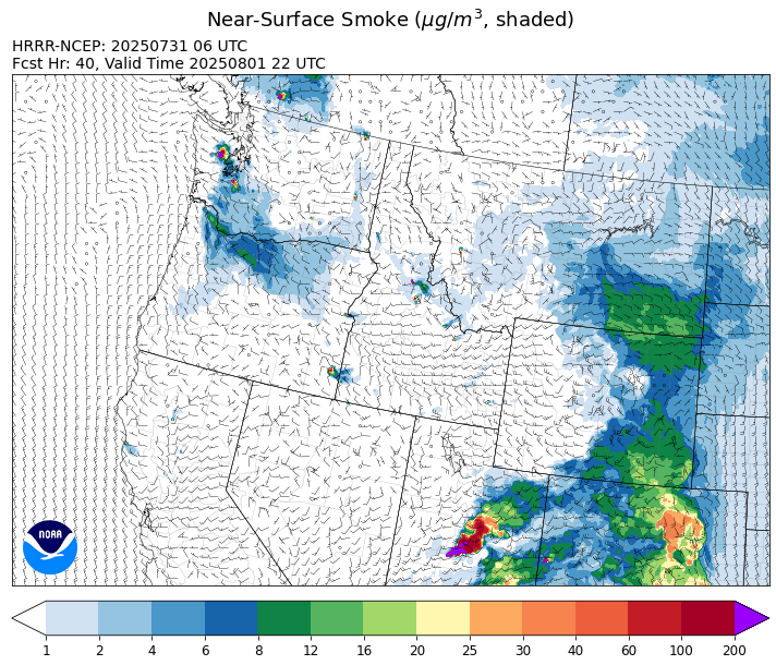
Source: HRRR-smoke
Forecast
Smoke models continue to signal that light surface smoke will move into the southern part of the Treasure State on Thursday from active wildfires burning in Utah and Arizona. This southerly flow will also send anomalously moist, monsoonal air into the state. The moisture combined with afternoon heating should be enough to initiate scattered thunderstorms. Main threats from these storms will be from heavy rain and frequent lightning. Fuel moistures remain unusually wet for the end of July. However, portions of southwest Montana have fuel moistures that are closer to normal, and more conducive to seeing new fire starts due to lightning. On average, fuels are driest and most receptive to fire over Montana by late July and early August.
The threat for storms shifts a bit north on Friday, particularly over the higher terrain. Unusually most monsoonal air will be in place and another round of heavy rain is possible. Easterly surface winds will funnel light surface smoke over the eastern half of the state from wildfires burning in Canada.
A large trough will keep precipitation in the forecast through early next week. At the same time, a southwesterly flow will continue pumping moisture into the state. Precipitation combined with seasonably cool temperatures should moderate fire behavior and limit smoke production on regional wildfires. Stay tuned!
Conditions can change quickly as weather could stimulate active fires and the likelihood of new starts increases. Please keep track of concentrations at todaysair.mtdeq.us or the Fire and Smoke Map.
Thursday morning’s satellite reveals some light smoke over eastern Montana from regional wildfires.
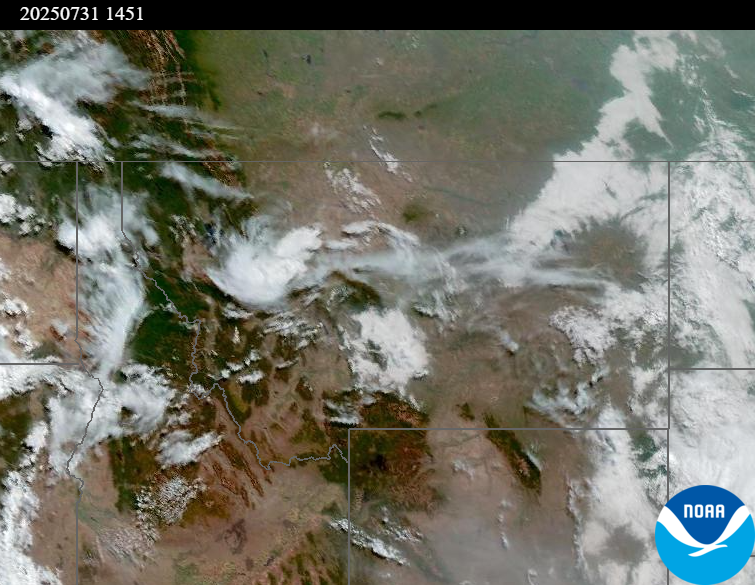
Source: NOAA
| Incident Name | State | Location | Acres | Containment |
|---|---|---|---|---|
| Rush | Idaho | 57 Miles NW of McCall, Idaho - Frank Church-River of No Return Wilderness | 7382 | 50% |
| Big Bear | Idaho | 59 Miles NE of McCall, Idaho - Frank Church-River of No Return Wilderness | 14935 | 75% |
| Shingle | Idaho | NA | 100 | NA |
| Post Fire | Idaho | North of US Highway 12, East of Mocus Point Trailhead | 144 | 94% |
| Sucker Creek Fire | Montana | 2 miles northwest of Lincoln, Montana | 80 | NA |
| Green Mountain Fire & Garnet Fire | Montana | NA | 70 | 75% |
| Observation Point Fire | Montana, United States | Lost Horse Canyon, 10.5 miles south of Hamilton, MT | 105 | 57% |
| Dominic Point Fire | Montana, United States | NA | 20 | 0% |
| Butte Creek | Oregon | 2 miles west of Simnasho, Oregon | 2079 | 85% |
| Hagelstein Fire | Oregon | 14 miles north of Klamath Falls, Oregon | 669 | 75% |
| Elk Fire | Oregon | 7 miles SW of Beatty, Oregon | 2637 | 95% |
| Burdoin Fire | Washington | 2.5 miles east of White Salmon | 10675 | 79% |
| Hope Fire | Washington | Approximately 15 Miles north of Kettle Falls, WA and 5 miles southwest of Northport, WA | 8177 | 79% |
| Bear Gulch Fire | Washington | 10 Miles Northwest of Hoodsport, WA | 1989 | 3% |
| Pomas Fire | Washington | Approximately 36 miles northwest of Entiat, WA | 3454 | NA |
Tags: Smoke Forecast 2025