
Smoke Forecast for Wednesday, July 31, 2024 10:00 AM
Current Conditions
The area of low pressure that brough rain to the Northern Rockies and Montana on Tuesday has moved east of the state. It helped to scour out much of the smoke from regional wildfires, leaving Montana with better air quality.
The rain that fell on Tuesday helped to reduce smoke production on existing wildfires. As much as an inch of rain fell in the Bitterroot Mountains where numerous wildfires continue to burn. The Wye fire just west of Hamilton is 0% contained and has grown to over 7,000 acres. The Thunder fire south of Salmon, Idaho is around 2,500 acres and is 34% contained.
At 9:00 AM Wednesday, Great Falls, Miles City, Glendive, Sidney, and Broadus were enduring Moderate air quality.
Wednesday morning’s satellite shows smoke-free skies over Western Montana, with abundant smoke to the south.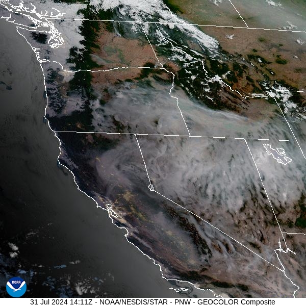
Source: NOAA
Forecast
The area of low pressure responsible for Tuesday’s rain is slowly moving away from the Northern Rockies. The storm produced as much as an inch of rain over the higher terrain of Montana and Idaho, temporarily reducing smoke production.
A ridge of high pressure builds over the region Wednesday and will remain a theme into the weekend. The ridge will bring another round of unseasonably warm temperatures back to the state. The combination of drying fuels, low humidity, and warm temperatures will lead to increased fire behavior on existing blazes. As a result, smoke production will increase on many of the regional wildfires, eventually leading to degrading air quality in Montana.
By late Saturday and Sunday, monsoonal moisture will move into the Treasure State. Some forecast models want to keep this moisture around into early next week. This moisture will increase our chances for rain and scattered thunderstorms. If verified, the pattern will also help to ease fire behavior on existing wildfire and reduce smoke production for the Northern Rockies.
By Thursday afternoon, the HRRR smoke model shows much of the heaviest smoke concentrations remaining south of Montana.
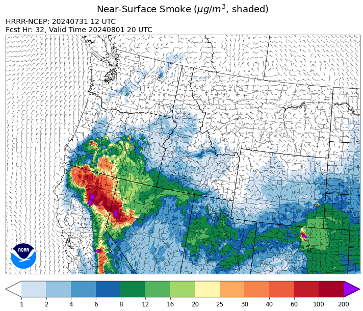
Source: HRRR Smoke
Conditions can change quickly as weather could stimulate active fires and the likelihood of new starts increases. Please keep track of concentrations at todaysair.mtdeq.us or the Fire and Smoke Map.
Current Wildfires
|
Incident |
State |
location |
acres |
containment |
|
Limepoint Fire - IDPAF |
Idaho |
8 miles NE of Oxbow Dam |
17,908 |
0% |
|
Wolf Creek Fire - IDPAF |
Idaho |
5 miles west of Donnelly, ID |
750 |
0% |
|
Bench Lake Fire - IDSTF |
Idaho |
8 miles south of Stanley, Idaho |
2,595 |
85% |
|
Cliff Mountain - IDPAF |
Idaho |
25 Miles East of Joseph, Oregon |
1,101 |
0% |
|
Boulder Fire - IDBOF |
Idaho |
9 Miles southwest of Cascade, Idaho. |
325 |
0% |
|
Wapiti Fire - IDBOF |
Idaho |
2 miles southwest of Grandjean |
50 |
NA |
|
Bulltrout Fire - IDBOF |
Idaho |
Southwest of Bull Trout Lake |
100 |
0% |
|
2024 Gwen Fire - IDIDS |
Idaho |
South of Juliaetta Idaho, about 30 miles outside Lewiston near State Highway 3 in Latah County |
28,805 |
34% |
|
Bluff Creek Complex - IDIPF |
Idaho |
The fires are burning along both sides of the Bluff Ridge, approximately 13 1/2 miles southeast of Avery, ID; five and a half miles west from Gold Creek Campground; and approximately two miles northwest of Junction Ridge. |
573 |
NA |
|
Oxbow Fire - IDPAF |
Idaho |
Near Oxbow dam in Hells Canyon |
6,000 |
NA |
|
Anchor - IDNCF |
Idaho |
About half way between Hanover Mountain and Square Mountain in the Gospel Hump Wilderness |
50 |
NA |
|
Shepp - IDNCF |
Idaho |
Approximately 30 miles Southwest of Elk City, Idaho |
75 |
NA |
|
Ace Butte - IDNCF |
Idaho |
Approximately 30 miles Southeast of Grangeville, Idaho |
75 |
NA |
|
Wye Fire - IDNCF |
Idaho |
Approximately four and a half miles northwest of Freeman Peak and seven miles northeast of the Moose Creek Airstrip |
3,500 |
NA |
|
Texas Fire - IDIDS |
Idaho |
Two miles East of Kendrick, ID |
1,582 |
90% |
|
Thunder Fire - IDSCF |
Idaho, United States |
12 miles south, southwest of Salmon, ID |
2,474 |
34% |
|
Miller Peak Fire - MTLNF |
Montana |
7 miles southeast of Missoula |
2,724 |
65% |
|
Black Mountain - MTHLF |
Montana |
6 miles northwest of Lincoln. Mont. |
65 |
0% |
|
Muir Creek Fire - MTGNP |
Montana |
20 miles southeast of West Glacier, MT and east of the Middle Fork of the Flathead River |
30 |
0% |
|
Blacktail Canyon - MTBDF |
Montana |
4 miles southeast of Butte, MT |
80 |
95% |
|
Butler Creek Fire - MTMTS |
Montana |
5 miles northwest of Missoula |
284 |
100% |
|
Courtrock Fire - OR95S |
Oregon |
7.1 Miles S. of Monument, Oregon |
19,834 |
37% |
|
Adam Mountain - ORUPF |
Oregon |
Approximately 6 miles southeast of Dorena, Oregon |
8,027 |
7% |
|
Durkee Fire - ORVAD |
Oregon |
1 mile west of Durkee, Oregon |
293,882 |
52% |
|
Whisky Creek Fire - ORMHF |
Oregon |
East fork of Herman Creek, 6 miles SE of Cascade Locks, OR |
891 |
0% |
|
Battle Mountain Complex - OR97S |
Oregon |
West and south of Ukiah, OR |
178,171 |
14% |
|
Winding Waters Complex - OR97S |
Oregon |
23 miles east of Union, OR |
752 |
5% |
|
Homestead Complex - ORUPF |
Oregon |
Thirty miles northeast of Glide Oregon |
1,636 |
5% |
|
Badland Complex 2024 - ORVAD |
Oregon |
Baker County, Oregon |
54,615 |
65% |
|
Red Fire - ORDEF |
Oregon |
Diamond Peak Wilderness |
428 |
0% |
|
Ore Fire - ORWIF |
Oregon |
7 Miles NE of Blue River, OR |
1,452 |
29% |
|
Microwave Tower Fire - OR95S |
Oregon |
5 miles WSW of Mosier, OR |
1,306 |
53% |
|
Middle Fork Fire - ORCLP |
Oregon |
Middle Fork area, west of Crater Lake, Crater Lake National Park |
728 |
1% |
|
Diamond Complex - ORUPF |
Oregon |
18 miles southwest of Chemult, Oregon |
5,188 |
9% |
|
Boulder Fire - ORMHF |
Oregon |
Approximately 26 miles SW of Dufur, OR. |
233 |
100% |
|
Lone Rock Fire - ORPRD |
Oregon |
Lone Rock OR stretching to west of HWY 207 and south to HWY 19 |
137,221 |
80% |
|
Mineral - ORUPF |
Oregon |
Approximately 7 miles southeast of Dorena, Oregon |
1,201 |
0% |
|
Quartz - ORUPF |
Oregon |
10 miles SSE Dorena, OR |
974 |
0% |
|
Jack Saddle - ORUPF |
Oregon |
Approximately 10 miles SSE of Dorena, Oregon |
1,248 |
0% |
|
Puddin - ORUPF |
Oregon |
Approximately 13 miles southeast of Dorena, OR |
392 |
0% |
|
Cottage Grove - Lane 1 - OR77S |
Oregon |
Approximately 16 miles SE of Springfield, OR |
1,932 |
0% |
|
Clark 900 - OR770S |
Oregon |
37 miles northeast of Roseburg, OR |
3,747 |
0% |
|
Falls Fire - ORMAF |
Oregon |
20 miles NW of Burns |
142,307 |
69% |
|
Telephone Fire - ORMAF |
Oregon |
16 miles north east of Burns, Oregon |
31,721 |
0% |
|
Crazy Creek - OROCF |
Oregon |
Crazy Creek:16 miles north of Paulina, OR |
21,937 |
0% |
|
Cow Valley Fire - ORVAD |
Oregon |
West of Brogan and Northwest of Vale |
133,490 |
99% |
|
South Columbia Basin - WANES |
Washington |
9.5 Miles WSW of Cheney, WA |
252 |
85% |
|
Big Horn Fire - WASES |
Washington |
7 miles SE of Bickleton Washington, and 7 miles N of Roosevelt, Washington |
51,569 |
100% |
|
Retreat - WASES |
Washington |
14 miles southwest of Naches, WA |
29,203 |
18% |
|
Easy Fire - WAOWF |
Washington |
North Cascades Hwy 20 Corridor, 17 air miles west of Mazama, WA |
528 |
0% |
|
Cougar Creek Fire - WASES |
Washington |
1 mile west of Hwy 129 and Grand Ronde river intersection |
17,602 |
29% |
|
Pioneer - WASES |
Washington |
Approximate start 10 miles southeast of Stehekin, WA |
33,276 |
15% |
|
Swawilla Fire - WACOA |
Washington |
North of Columbia River, East of Swawilla Basin, West of Hwy 21 |
47,190 |
45% |
|
Bridge Creek - WACOA |
Washington |
North of Bridge Creek, East of Elbow River |
3,950 |
43% |
|
Lower Granite Fire - WANES |
Washington |
Northeast of Pomeroy, WA |
14,482 |
0% |
|
Pincer Two Fire - WAMSF |
Washington |
Johanasburg Mountain. 1 Mile East of Mineral Park C.G. |
102 |
0% |
|
Black Canyon - WASES |
Washington |
10 Miles NW, Naches, WA |
9,211 |
89% |
Source: Inciweb
Tags: Smoke Forecast 2024