
Smoke Forecast for Wednesday, July 30, 2025 9:45 AM
Current Conditions
Beneficial rain fell on Tuesday across parts of Montana. Some surface smoke is impacting eastern Montana from wildfires burning in Canada.
The Sucker Creek fire started on Sunday and grew rapidly because of gusty outflow winds from thunderstorms. It is located 2 miles northwest of Lincoln and has burned 80 acres. Firefighters have made good progress on the Observation Point fire burning just outside Hamilton. It is up to 105 acres and is now 57% contained. The Deer fire burning just southeast of Missoula has burned 75 acres and is 90% contained. The Big Bear and Rush fires continue to burn in the Bitterroot Range of central Idaho, just southwest of the Bitterroot Valley. The Big Bear fire has grown to 11,241 acres and is 75% contained while the Rush fire is up to 7,185 acres and is 50% contained. Cooler weather and higher humidity continue to limit smoke production on these blazes.
At 9:00 AM Wednesday, Sidney, Malta, Havre, Great Falls, Glendive, Miles City, and Bozeman's air quality is Moderate.
By late Thursday morning, the HRRR smoke model shows some light surface smoke over eastern Montana from Canadian wildfires.
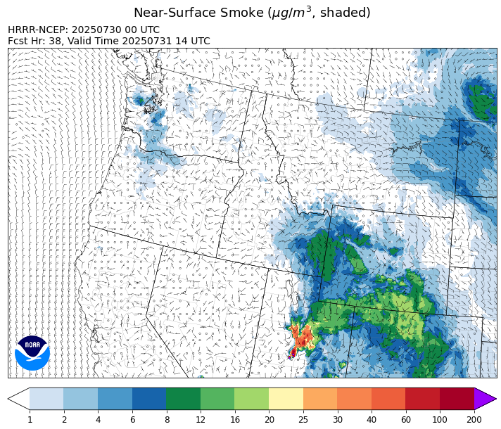
Source: HRRR-smoke
Forecast
Easterly winds will help to push surface smoke from Canadian wildfires into the eastern third of the state on Wednesday. However, smoke models indicate that it won’t be a major impact to air quality, and that the Air Quality Index should generally stay below Unhealthy for Sensitive Groups.
Monsoonal moisture continues to stream north into the Treasure State over the coming days. Afternoon heating should be enough to kick off a few scattered thunderstorms on Wednesday, primarily over the mountains. The main threats from these storms will be torrential rain, gusty winds, and even some hail. Since these storms will be slow movers, there is the potential for flash flooding, particularly in the mountains and in communities adjacent to these storms.
The anomalously moist airmass remains in place across the Treasure State between Thursday and Friday. A series of disturbances will be enough to initiate convection across the area, with more widespread thunderstorms and heavy rainfall a good bet. The precipitation should help to moderate fire behavior and limit smoke production on existing wildfires. Fuel moistures are unseasonably wet across most of the state. However, fuel moisture over parts of southwest Montana are closer to normal, and will be more conducive to new fire starts with the lightning anticipated between Thursday and Friday. Stay tuned!
Conditions can change quickly as weather could stimulate active fires and the likelihood of new starts increases. Please keep track of concentrations at todaysair.mtdeq.us or the Fire and Smoke Map.
Wednesday morning’s satellite shows light smoke over northeast Montana from Canadian wildfires.
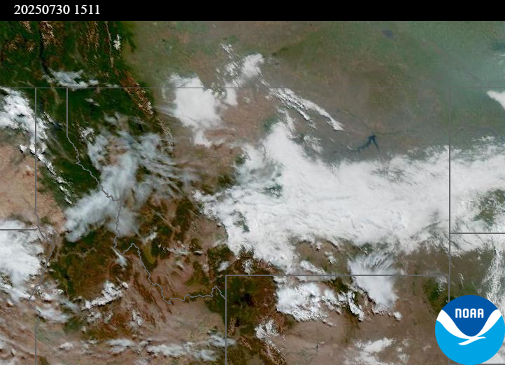
Source: NOAA
| Incident Name | State | Location | Acres | Containment |
|---|---|---|---|---|
| Rush | Idaho | 57 Miles NW of McCall, Idaho - Frank Church-River of No Return Wilderness | 7185 | 50% |
| Big Bear | Idaho | 59 Miles NE of McCall, Idaho - Frank Church-River of No Return Wilderness | 11241 | 75% |
| Shingle | Idaho | NA | 100 | NA |
| Post Fire | Idaho | North of US Highway 12, East of Mocus Point Trailhead | 144 | 94% |
| Sucker Creek Fire | Montana | 2 miles northwest of Lincoln, Montana | 80 | NA |
| Deer Fire | Montana | NA | 75 | 90% |
| Green Mountain Fire & Garnet Fire | Montana | NA | 70 | 75% |
| Dominic Butte Fire | Montana | NA | 20 | 0% |
| Observation Point Fire | Montana | Lost Horse Canyon, 10.5 miles south of Hamilton, MT | 105 | 57% |
| Butte Creek | Oregon | 2 miles west of Simnasho, Oregon | 2079 | 85% |
| Hagelstein Fire | Oregon | 14 miles north of Klamath Falls, Oregon | 669 | 75% |
| Elk Fire | Oregon | 7 miles SW of Beatty, Oregon | 2637 | 95% |
| Hope Fire | Washington | Approximately 15 Miles north of Kettle Falls, WA and 5 miles southwest of Northport, WA | 8157 | 79% |
| Bear Gulch Fire | Washington | 10 Miles Northwest of Hoodsport, WA | 1275 | 8% |
| Pomas Fire | Washington | Approximately 36 miles northwest of Entiat, WA | 3452 | NA |
| Burdoin Fire | Washington | 2.5 miles east of White Salmon | 11192 | 72% |
Tags: Smoke Forecast 2025