
Smoke Forecast for Tuesday, July 30, 2024 10:30 AM
Current Conditions
Several regional wildfires have expanded significantly over the last 48-hours. However, a trough of low pressure will march across the Northern Rockies on Tuesday. It will gradually provide better air quality across the state.
The Wye fire just west of the Bitterroot Valley continues to grow. It has experienced significant growth this week with 0% of the fire contained. Showers and scattered thunderstorms are expected on Tuesday which should ease fire behavior and smoke production on this blaze.
At 10:00 AM Tuesday, Libby, Thompson Falls, Columbia Falls, Seeley Lake, Missoula, Butte, Dillon, Bozeman, West Yellowstone, Helena, Sleeping Giant, Great Falls, Lewistown, Billings, Miles City, Glendive, Sidney were enduring Moderate air quality. Broadus was experiencing air that is considered Unhealthy for Sensitive Groups.
Tuesday morning’s satellite shows a trough of low pressure marching across the Northern Rockies.
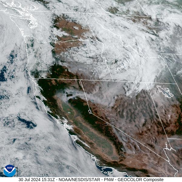
Source: NOAA
Forecast
A trough of low pressure will move across the Northern Rockies on Tuesday. It will provide some much-needed rainfall for the state and cooler temperatures. The rainfall should help to ease fire behavior and smoke production on existing wildfires. Apart from communities immediately adjacent to wildfires, the trough should provide a brief break from the heavy smoke we’ve endured of late. The spine of the Bitterroot Mountains, including the Wye fire, will see the most rain from this system. Up to half an inch of rain is possible along the Montana/Idaho border. The rain will gradually taper off by early Wednesday.
A ridge of high pressure will begin to move over the area on Wednesday and Thursday. It will allow temperatures to warm back up above average. Due to warm temperatures, gusty winds, and low humidity, there is a good chance for elevated fire weather conditions over parts of Montana between Friday and Saturday.
There are still numerous fires burning across California, Oregon, Washington, and Idaho. As the ridge builds and southerly winds return Friday and Saturday, some of the smoke from these fires will begin to move back into Montana. Stay tuned!
By Wednesday afternoon, the HRRR smoke model shows a departing trough providing some temporary relief from the smoke to much of the state.
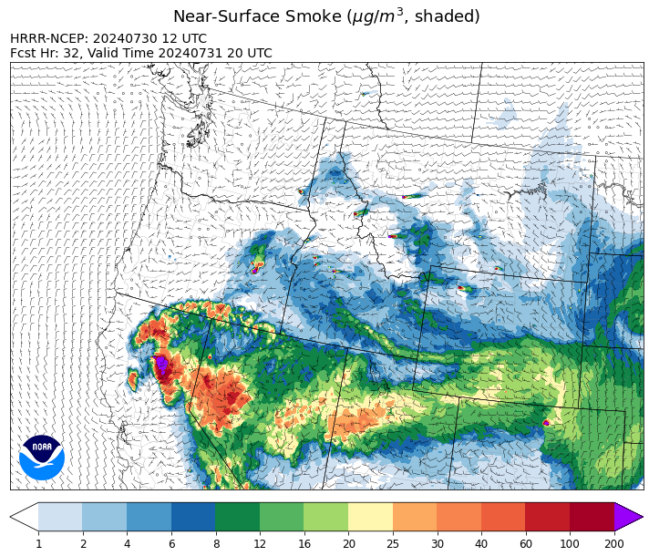
Source: HRRR Smoke
Conditions can change quickly as weather could stimulate active fires and the likelihood of new starts increases. Please keep track of concentrations at todaysair.mtdeq.us or the Fire and Smoke Map.
Current Wildfires
|
Incident |
State |
location |
acres |
containment |
|
2024 Gwen Fire - IDIDS |
Idaho |
South of Juliaetta Idaho, about 30 miles outside Lewiston near State Highway 3 in Latah County |
28,805 |
0% |
|
Wolf Creek Fire - IDPAF |
Idaho |
West facing slope of West Mountain, Council Ranger District, Payette National Forest |
909 |
0% |
|
Oxbow Fire - IDPAF |
Idaho |
Near Oxbow dam in Hells Canyon |
6,000 |
NA |
|
Limepoint Fire - IDPAF |
Idaho |
Hells Canyon, Council Ranger District Payette National Forest |
6,000 |
0% |
|
Cliff Mountain - IDPAF |
Idaho |
25 Miles East of Joseph, Oregon |
817 |
0% |
|
Boulder Fire - IDBOF |
Idaho |
9 Miles southwest of Cascade, Idaho. |
324 |
0% |
|
Bench Lake Fire - IDSTF |
Idaho |
8 miles south of Stanley, Idaho |
2,595 |
85% |
|
Anchor - IDNCF |
Idaho |
About half way between Hanover Mountain and Square Mountain in the Gospel Hump Wilderness |
50 |
NA |
|
Shepp - IDNCF |
Idaho |
Approximately 30 miles Southwest of Elk City, Idaho |
75 |
NA |
|
Ace Butte - IDNCF |
Idaho |
Approximately 30 miles Southeast of Grangeville, Idaho |
75 |
NA |
|
Bluff Creek Complex - IDIPF |
Idaho |
The fires are burning along both sides of the Bluff Ridge, approximately 13 1/2 miles southeast of Avery, ID; five and a half miles west from Gold Creek Campground; and approximately two miles northwest of Junction Ridge. |
530 |
NA |
|
Wye Fire - IDNCF |
Idaho |
Approximately four and a half miles northwest of Freeman Peak and seven miles northeast of the Moose Creek Airstrip |
3,500 |
NA |
|
Bull Trout Fire - IDBOF |
Idaho |
Southwest of Bull Trout Lake |
100 |
0% |
|
Wapiti Fire - IDBOF |
Idaho |
2 miles southwest of Grandjean |
50 |
NA |
|
Texas Fire - IDIDS |
Idaho |
Two miles East of Kendrick, ID |
1,582 |
90% |
|
Thunder Fire - IDSCF |
Idaho, United States |
12 miles south, southwest of Salmon, ID |
2,474 |
34% |
|
Miller Peak Fire - MTLNF |
Montana |
7 miles southeast of Missoula |
2,724 |
65% |
|
Black Mountain - MTHLF |
Montana |
6 miles northwest of Lincoln. Mont. |
65 |
0% |
|
Blacktail Canyon - MTBDF |
Montana |
4 miles southeast of Butte, MT |
80 |
95% |
|
Muir Creek Fire - MTGNP |
Montana |
20 miles southeast of West Glacier, MT and east of the Middle Fork of the Flathead River |
30 |
0% |
|
Butler Creek Fire - MTMTS |
Montana |
5 miles northwest of Missoula |
284 |
100% |
|
Horse Gulch Fire - MTHLF |
Montana |
1/2 mile north of Canyon Ferry Dam near Helena, Montana |
15,167 |
100% |
|
Deadman Fire - MTMTS |
Montana |
Approx 17 mi south of Birney and north of the Tongue River Reservoir in Rosebud and Big Horn Counties |
47,827 |
NA |
|
Badland Complex 2024 - ORVAD |
Oregon |
Baker County, Oregon |
54,618 |
49% |
|
Ore Fire - ORWIF |
Oregon |
7 Miles NE of Blue River, OR |
1,452 |
29% |
|
Courtrock Fire - OR95S |
Oregon |
7.1 Miles S. of Monument, Oregon |
17,066 |
31% |
|
Lone Rock Fire - ORPRD |
Oregon |
Lone Rock OR stretching to west of HWY 207 and south to HWY 19 |
137,221 |
77% |
|
Whisky Creek Fire - ORMHF |
Oregon |
East fork of Herman Creek, 6 miles SE of Cascade Locks, OR |
891 |
0% |
|
Falls Fire - ORMAF |
Oregon |
20 miles NW of Burns |
142,307 |
69% |
|
Cottage Grove - Lane 1 - OR77S |
Oregon |
Approximately 16 miles SE of Springfield, OR |
1,932 |
0% |
|
Homestead Complex - ORUPF |
Oregon |
Thirty miles northeast of Glide Oregon |
1,636 |
5% |
|
Adam Mountain - ORUPF |
Oregon |
Approximately 6 miles southeast of Dorena, Oregon |
8,027 |
0% |
|
Diamond Complex - ORUPF |
Oregon |
18 miles southwest of Chemult, Oregon |
5,188 |
9% |
|
Durkee Fire - ORVAD |
Oregon |
1 mile west of Durkee, Oregon |
293,390 |
51% |
|
Winding Waters Complex - OR97S |
Oregon |
23 miles east of Union, OR |
718 |
0% |
|
Battle Mountain Complex - OR97S |
Oregon |
West and south of Ukiah, OR |
178,171 |
10% |
|
Red Fire - ORDEF |
Oregon |
Diamond Peak Wilderness |
428 |
0% |
|
Middle Fork Fire - ORCLP |
Oregon |
Middle Fork area, west of Crater Lake, Crater Lake National Park |
715 |
1% |
|
Microwave Tower Fire - OR95S |
Oregon |
5 miles WSW of Mosier, OR |
1,306 |
53% |
|
Telephone Fire - ORMAF |
Oregon |
16 miles north east of Burns, Oregon |
26,000 |
0% |
|
Cow Valley Fire - ORVAD |
Oregon |
West of Brogan and Northwest of Vale |
133,490 |
99% |
|
Quartz - ORUPF |
Oregon |
10 miles SSE Dorena, OR |
974 |
0% |
|
Mineral - ORUPF |
Oregon |
Approximately 7 miles southeast of Dorena, Oregon |
1,201 |
0% |
|
Puddin - ORUPF |
Oregon |
Approximately 13 miles southeast of Dorena, OR |
392 |
0% |
|
Jack Saddle - ORUPF |
Oregon |
Approximately 10 miles SSE of Dorena, Oregon |
1,248 |
0% |
|
Clark 900 - OR770S |
Oregon |
37 miles northeast of Roseburg, OR |
3,747 |
0% |
|
Crazy Creek - OROCF |
Oregon |
Crazy Creek:16 miles north of Paulina, OR |
16,978 |
0% |
|
Cougar Creek Fire - WASES |
Washington |
1 mile west of Hwy 129 and Grand Ronde river intersection |
17,602 |
29% |
|
Retreat - WASES |
Washington |
14 miles southwest of Naches, WA |
29,499 |
11% |
|
Pioneer - WASES |
Washington |
Approximate start 10 miles southeast of Stehekin, WA |
33,276 |
15% |
|
Easy Fire - WAOWF |
Washington |
North Cascades Hwy 20 Corridor, 17 air miles west of Mazama, WA |
528 |
0% |
|
Big Horn Fire - WASES |
Washington |
7 miles SE of Bickleton Washington, and 7 miles N of Roosevelt, Washington |
50,061 |
92% |
|
Bridge Creek - WACOA |
Washington |
North of Bridge Creek, East of Elbow River |
3,950 |
43% |
|
Swawilla Fire - WACOA |
Washington |
North of Columbia River, East of Swawilla Basin, West of Hwy 21 |
47,190 |
45% |
|
South Columbia Basin - WANES |
Washington |
9.5 Miles WSW of Cheney, WA |
252 |
20% |
|
Pincer Two Fire - WAMSF |
Washington |
Johanasburg Mountain. 1 Mile East of Mineral Park C.G. |
82 |
0% |
|
Black Canyon - WASES |
Washington |
10 Miles NW, Naches, WA |
9,211 |
89% |
Source: Inciweb
Tags: Smoke Forecast 2024