
Smoke Forecast for Tuesday, July 29, 2025 9:30 AM
Current Conditions
Some beneficial rain fell across parts of the Northern Rockies on Monday, and additional rain is possible again on Tuesday.
The Sucker Creek fire started on Sunday and grew rapidly because of gusty winds. It is located 3 miles northwest of Lincoln and has burned 80 acres. Firefighters have made good progress on the Observation Point fire burning just outside Hamilton. It is up to 105 acres and is now 57% contained. The Deer fire burning just southeast of Missoula has burned 75 acres and is 90% contained. The Big Bear and Rush fires continue to burn in the Bitterroot Range of central Idaho, just southwest of the Bitterroot Valley. The Big Bear fire has grown to 11,241 acres and is 75% contained while the Rush fire is up to 7,185 acres and is 50% contained. Cooler weather and higher humidity continue to limit smoke production on these blazes.
At 9:00 AM Tuesday, Sidney, Malta, Havre, Great Falls, Sleeping Giant, and Billings’ air quality is Moderate.
By Wednesday morning, the HRRR smoke model shows some light surface smoke over eastern Montana from Canadian wildfires.
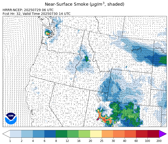
Source: HRRR-smoke
Forecast
A southwesterly flow will continue to pump moist, monsoonal moisture into the state the next several days. At the same time, a series of weak disturbances will march across Montana, initiating afternoon thunderstorm activity. Not everyone will receive rain, but any of these storms will have the potential to produce torrential rain, frequent lightning, and gusty winds. Fuel moistures remain anomalously wet across most of the state. However, fuel moistures in much of southwest Montana are closer to average and will be more conducive to new fires in the coming days, particularly with lightning on the landscape.
By late Tuesday, a weak front will shift the surface winds over eastern Montana to the east. This will bring some light surface smoke from Canadian wildfires to the eastern half of the state through Wednesday. Expect some minor impacts to air quality, but values shouldn’t get worse than Moderate during this episode.
A more robust system will march across the Northern Rockies Thursday and Friday. It will interact with the moist and unstable airmass and provide the best chances for widespread precipitation and thunderstorms across the state. The precipitation will help to moderate fire behavior around the region and reduce surface smoke. However, there will likely be additional fire starts because of the lightning, particularly where fuel moistures remain dry across southwest Montana. Stay tuned!
Conditions can change quickly as weather could stimulate active fires and the likelihood of new starts increases. Please keep track of concentrations at todaysair.mtdeq.us or the Fire and Smoke Map.
Tuesday morning’s satellite shows a few thunderstorms over eastern Montana behind a departing area of low pressure.
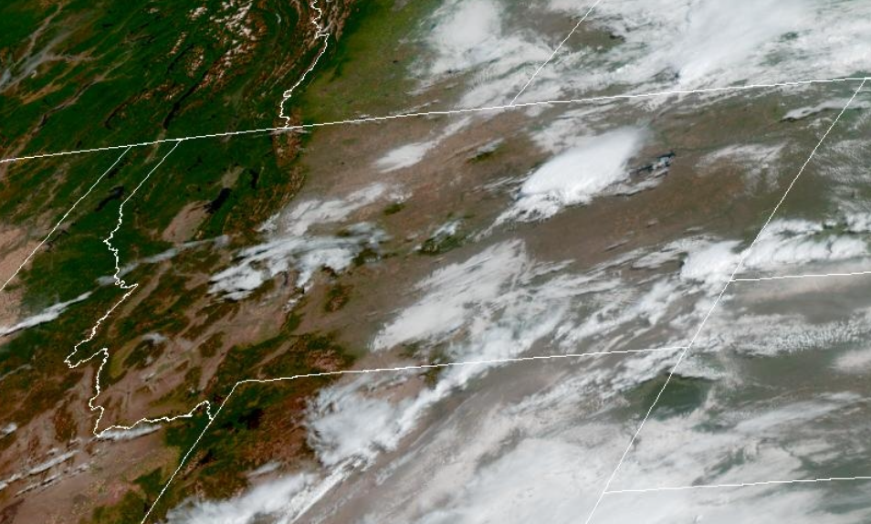
Source: NOAA
| Incident Name | State | Location | Acres | Containment |
|---|---|---|---|---|
| Big Bear | Idaho | 59 Miles NE of McCall, Idaho - Frank Church-River of No Return Wilderness | 11241 | NA |
| Rush | Idaho | 57 Miles NW of McCall, Idaho - Frank Church-River of No Return Wilderness | 7185 | NA |
| Shingle | Idaho | NA | 100 | NA |
| Post Fire | Idaho | North of US Highway 12, East of Mocus Point Trailhead | 144 | 94% |
| Sucker Creek Fire | Montana | 3 miles northwest of Lincoln, Montana | 80 | NA |
| Deer Fire | Montana | NA | 75 | 90% |
| Green Mountain Fire & Garnet Fire | Montana | NA | 70 | 75% |
| Dominic Butte Fire | Montana, United States | NA | 20 | 0% |
| Observation Point Fire | Montana, United States | Lost Horse Canyon, 10.5 miles south of Hamilton, MT | 105 | 57% |
| Butte Creek | Oregon | 2 miles west of Simnasho, Oregon | 2079 | 85% |
| Hagelstein Fire | Oregon | 14 miles north of Klamath Falls, Oregon | 669 | 75% |
| Elk Fire | Oregon | 7 miles SW of Beatty, Oregon | 2637 | 95% |
| Burdoin Fire | Washington | 2.5 miles east of White Salmon | 11192 | 69% |
| Hope Fire | Washington | Approximately 15 Miles north of Kettle Falls, WA and 5 miles southwest of Northport, WA | 8157 | 79% |
| Lake Spokane Fire | Washington | 12 Miles NW of Spokane, WA | 2512 | 90% |
| Bear Gulch Fire | Washington | 10 Miles Northwest of Hoodsport, WA | 1094 | 10% |
| Pomas Fire | Washington | Approximately 36 miles northwest of Entiat, WA | 3450 | NA |
Tags: Smoke Forecast 2025