
Smoke Forecast for Monday, July 29, 2024 10:00 AM
Current Conditions
Montana Department of Environmental Quality has issued an air quality alert for Deer Lodge, Granite, Ravalli, and Silver Bow counties in effect until 8AM 7/30/2024 due to elevated particulate levels from wildfire smoke.
The Wye fire in Idaho has grown rapidly over the last couple of days. There hasn’t been an update to the fire since Friday. The fire has burned well over 7,000 acres.
The Miller Peak fire outside Missoula has burned over 2,700 acres with 65 percent containment. It has grown little over the last few days. The staff managing the Miller Peak fire will transition to a smaller organization, as other fires in the region are becoming more of a priority.
See the latest Air Resource Advisor report from the Miller Peak/Wye Mcrd fires here
At 9:00 AM Monday, Libby, Thompson Falls, Columbia Falls, Seeley Lake, Frenchtown, Missoula, Butte, Dillon, Bozeman, West Yellowstone, Helena, Sleeping Giant, Cut Bank, Great Falls, Lewistown, Billings, Broadus, Miles City, Glendive, Sidney, Choteau, Havre, Malta, were enduring Moderate air quality.
Monday morning’s satellite reveals heavy smoke pouring into Montana from numerous regional wildfires.
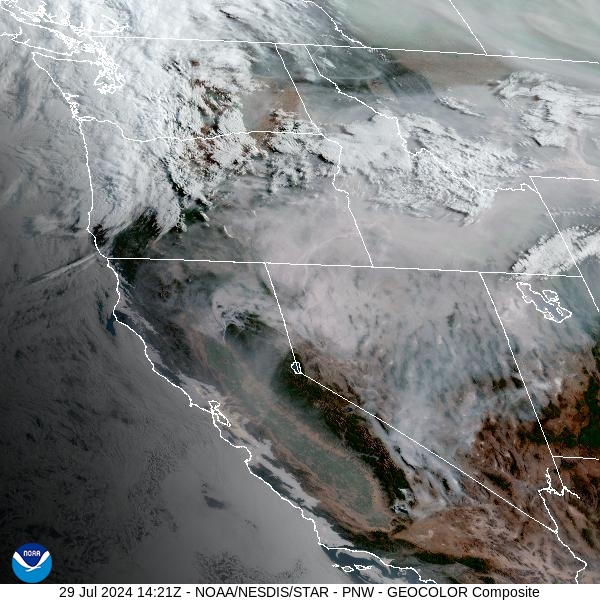
Source: NOAA
Forecast
A westerly flow will continue to send smoke from upstream fires into Montana to start the week. The Wye fire just west of the Bitterroot Mountains in Idaho has grown considerably in the last few days. It will continue to send plumes of heavy smoke into parts of Southwest Montana, impacting air quality values. Gusty winds will lead to erratic fire behavior on existing wildfires, but gradually scour out some of the smoke in the valleys by the afternoon and early evening.
Some beneficial rain is expected for parts of Western Montana by Monday afternoon and evening, particularly in the higher terrain of Northwest Montana. The Bitterroot Mountains will also see some much-needed rain from the system, and this could ease fire behavior on the Wye blaze.
High pressure builds over the area starting Wednesday. It will provide another round of unseasonably warm weather for the state and produce mostly dry conditions. The pattern will also allow existing wildfires to expand, with the usual diurnal fluctuations in smoke. High pressure tends to bring overnight pooling and draining of smoke, with deteriorating air quality. Once the inversion breaks around midday, increasing winds will help to provide gradual improvements to air quality.
By Tuesday afternoon, the HRRR smoke model shows a trough bringing some temporary relief from the smoke to parts of Southwest Montana, while the Wye fire continue to send smoke into parts of the Bitterroot Valley.
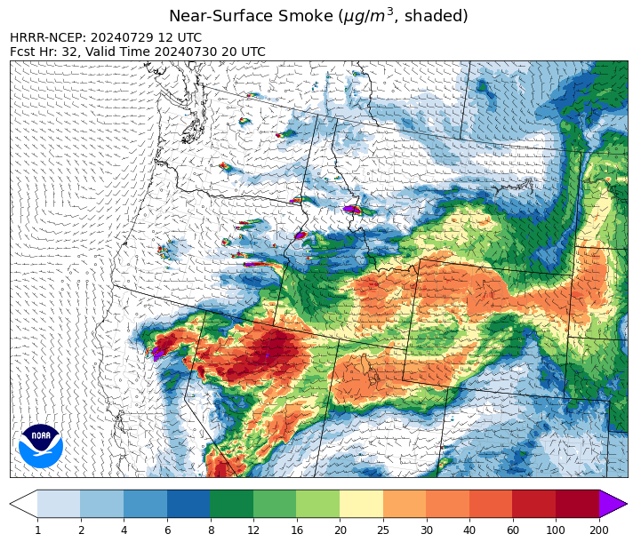
Source: HRRR Smoke
Conditions can change quickly as weather could stimulate active fires and the likelihood of new starts increases. Please keep track of concentrations at Today's Air or the Fire and Smoke Map.
Current Wildfires
|
Incident |
State |
location |
acres |
containment |
|
Boulder Fire - IDBOF |
Idaho |
9 Miles southwest of Cascade, Idaho. |
260 |
0% |
|
Bench Lake Fire - IDSTF |
Idaho |
8 miles south of Stanley, Idaho |
2,595 |
85% |
|
2024 Gwen Fire - IDIDS |
Idaho |
South of Juliaetta Idaho, about 30 miles outside Lewiston near State Highway 3 in Latah County |
27,714 |
0% |
|
Wolf Creek Fire - IDPAF |
Idaho |
West facing slope of West Mountain, Council Ranger District, Payette National Forest |
1,500 |
0% |
|
Oxbow Fire - IDPAF |
Idaho |
Near Oxbow dam in Hells Canyon |
6,000 |
NA |
|
Limepoint Fire - IDPAF |
Idaho |
Hells Canyon, Council Ranger District Payette National Forest |
3,500 |
0% |
|
Bluff Creek Complex - IDIPF |
Idaho |
The fires are burning along both sides of the Bluff Ridge, approximately 13 1/2 miles southeast of Avery, ID; five and a half miles west from Gold Creek Campground; and approximately two miles northwest of Junction Ridge. |
425 |
NA |
|
Bull Trout Fire - IDBOF |
Idaho |
Southwest of Bull Trout Lake |
100 |
0% |
|
Wapiti Fire - IDBOF |
Idaho |
2 miles southwest of Grandjean |
50 |
NA |
|
Wye Fire - IDNCF |
Idaho |
Approximately four and a half miles northwest of Freeman Peak and seven miles northeast of the Moose Creek Airstrip |
7,000 |
NA |
|
Texas Fire - IDIDS |
Idaho |
Two miles East of Kendrick, ID |
1,582 |
90% |
|
Thunder Fire - IDSCF |
Idaho |
12 miles south, southwest of Salmon, ID |
2,474 |
34% |
|
Miller Peak Fire - MTLNF |
Montana |
7 miles southeast of Missoula |
2,724 |
65% |
|
Blacktail Canyon - MTBDF |
Montana |
4 miles southeast of Butte, MT |
80 |
95% |
|
Muir Creek Fire - MTGNP |
Montana |
20 miles southeast of West Glacier, MT and east of the Middle Fork of the Flathead River |
30 |
0% |
|
Butler Creek Fire - MTMTS |
Montana |
5 miles northwest of Missoula |
284 |
100% |
|
Horse Gulch Fire - MTHLF |
Montana |
1/2 mile north of Canyon Ferry Dam near Helena, Montana |
15,167 |
100% |
|
Deadman Fire - MTMTS |
Montana |
Approx 17 mi south of Birney and north of the Tongue River Reservoir in Rosebud and Big Horn Counties |
47,827 |
NA |
|
Crazy Creek - OROCF |
Oregon |
Crazy Creek:16 miles north of Paulina, OR |
16,978 |
0% |
|
Lone Rock Fire - ORPRD |
Oregon |
Lone Rock OR stretching to west of HWY 207 and south to HWY 19 |
137,221 |
77% |
|
Homestead Complex - ORUPF |
Oregon |
Thirty miles northeast of Glide Oregon |
1,466 |
4% |
|
Courtrock Fire - OR95S |
Oregon |
7.1 Miles S. of Monument, Oregon |
17,066 |
24% |
|
Microwave Tower Fire - OR95S |
Oregon |
5 miles WSW of Mosier, OR |
1,306 |
53% |
|
Whisky Creek Fire - ORMHF |
Oregon |
East fork of Herman Creek, 6 miles SE of Cascade Locks, OR |
891 |
0% |
|
Falls Fire - ORMAF |
Oregon |
20 miles NW of Burns |
142,307 |
69% |
|
Telephone Fire - ORMAF |
Oregon |
16 miles north east of Burns, Oregon |
26,000 |
0% |
|
Durkee Fire - ORVAD |
Oregon |
1 mile west of Durkee, Oregon |
288,690 |
49% |
|
Red Fire - ORDEF |
Oregon |
Diamond Peak Wilderness |
423 |
0% |
|
Battle Mountain Complex - OR97S |
Oregon |
West and south of Ukiah, OR |
172,334 |
8% |
|
Mineral - ORUPF |
Oregon |
Approximately 7 miles southeast of Dorena, Oregon |
1,201 |
0% |
|
Jack Saddle - ORUPF |
Oregon |
Approximately 10 miles SSE of Dorena, Oregon |
1,248 |
0% |
|
Adam Mountain - ORUPF |
Oregon |
Approximately 6 miles southeast of Dorena, Oregon |
5,720 |
0% |
|
Cottage Grove - Lane 1 - OR77S |
Oregon |
Approximately 16 miles SE of Springfield, OR |
1,617 |
0% |
|
Clark 900 - OR770S |
Oregon |
37 miles northeast of Roseburg, OR |
3,747 |
0% |
|
Middle Fork Fire - ORCLP |
Oregon |
Middle Fork area, west of Crater Lake, Crater Lake National Park |
714 |
1% |
|
Diamond Complex - ORUPF |
Oregon |
18 miles southwest of Chemult, Oregon |
4,990 |
7% |
|
Ore Fire - ORWIF |
Oregon |
7 Miles NE of Blue River, OR |
1,400 |
20% |
|
Badland Complex 2024 - ORVAD |
Oregon |
Baker County, Oregon |
54,566 |
40% |
|
Puddin - ORUPF |
Oregon |
Approximately 13 miles southeast of Dorena, OR |
392 |
0% |
|
Quartz - ORUPF |
Oregon |
10 miles SSE Dorena, OR |
974 |
0% |
|
Cow Valley Fire - ORVAD |
Oregon |
West of Brogan and Northwest of Vale |
133,490 |
99% |
|
Salt Creek - OR710S |
Oregon |
5 miles SSW of Butte Falls, Oregon |
4,102 |
100% |
|
Pioneer - WASES |
Washington |
Approximate start 10 miles southeast of Stehekin, WA |
33,276 |
15% |
|
Easy Fire - WAOWF |
Washington |
North Cascades Hwy 20 Corridor, 17 air miles west of Mazama, WA |
528 |
0% |
|
Retreat - WASES |
Washington |
14 miles southwest of Naches, WA |
22,421 |
4% |
|
Cougar Creek Fire - WASES |
Washington |
1 mile west of Hwy 129 and Grand Ronde river intersection |
15,703 |
29% |
|
South Columbia Basin - WANES |
Washington |
9.5 Miles WSW of Cheney, WA |
252 |
20% |
|
Big Horn Fire - WASES |
Washington |
7 miles SE of Bickleton Washington, and 7 miles N of Roosevelt, Washington |
50,061 |
52% |
|
Bridge Creek - WACOA |
Washington |
North of Bridge Creek, East of Elbow River |
3,950 |
43% |
|
Black Canyon - WASES |
Washington |
10 Miles NW, Naches, WA |
9,211 |
89% |
|
Swawilla Fire - WACOA |
Washington |
North of Columbia River, East of Swawilla Basin, West of Hwy 21 |
46,324 |
26% |
|
Pincer Two Fire - WAMSF |
Washington |
Johanasburg Mountain. 1 Mile East of Mineral Park C.G. |
82 |
0% |
Source: Inciweb
Tags: Smoke Forecast 2024