
Smoke Forecast for Sunday, July 26, 2026 9:30 AM
Current Conditions
Montana DEQ is issuing an Air Quality Alert for Choteau, Granite, Hill, Lewis and Clark, Libery, Missoula, Pondera, Powell, Ravalli, Teton, Toole Counties because of elevated particulate levels from wildfire smoke. The alert expires at 9AM Monday, July 27, 2026.
Hot, dry, and windy conditions across Montana set the stage for rapid fire spread on new wildfires Saturday. Air quality has rapidly deteriorated over several counties in southwest and northern Montana in response to these fires, and wildfires across Oregon and Washington.
The Perkins Fire west of Anaconda, the Elder 1 Fire just south of Frenchtown, and the North Fork Lost Horse Fire southwest of Hamilton grew rapidly on Saturday. Communities downwind of these fires will continue to see the greatest impacts to air quality.
At 9:00 AM Sunday, particulate levels in Cut Bank, Hamilton and Missoula are Unhealthy for Sensitive Groups. Air quality in Butte, Columbia Falls, Dillon, Frenchtown, Great Falls, Havre, Helena, Libby, Malta, Sleeping Giant and Thompson Falls are Moderate.
By Monday afternoon, the Rapid Refresh Forecast System (RRFS) smoke model shows areas of heavy smoke over much of the state from domestic and regional wildfires.
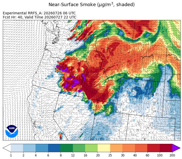
Source: HRRR-smoke
Forecast
Hot, dry, and windy conditions on Saturday led to rapid fire spread on new wildfires over Montana. Air quality will remain a concern for several counties in the state due to these fires and the blazes burning in Oregon and Washington. Sunday won’t be quite as warm as Saturday, but regional wildfires are expected to expand again Sunday thanks to unseasonably warm air and gusty afternoon winds.
The biggest concern from an air quality perspective in the coming days will be to overnight air quality. Each evening, elevated smoke will settle closer to the surface with decreased mixing, leading to worsening air quality. Starting around late morning, increasing solar radiation will increase wind speeds and help to scour out much of the valley smoke.
Unfortunately, there isn’t much relief in the immediate future. Unseasonably warm air, low humidities, and gusty afternoon winds will lead to additional fire spread on regional wildfires. However, by the end of the week, we will start to see the ridge of high pressure break down. Along with cooler temperatures, we will likely see some improvements to air quality. Stay tuned!
Conditions can change quickly as weather could stimulate active fires and the likelihood of new starts increases. Please keep track of concentrations at todaysair.mtdeq.us or the Fire and Smoke Map.
Smoke from regional wildfires is creating smoky skies early Sunday morning across much of Montana.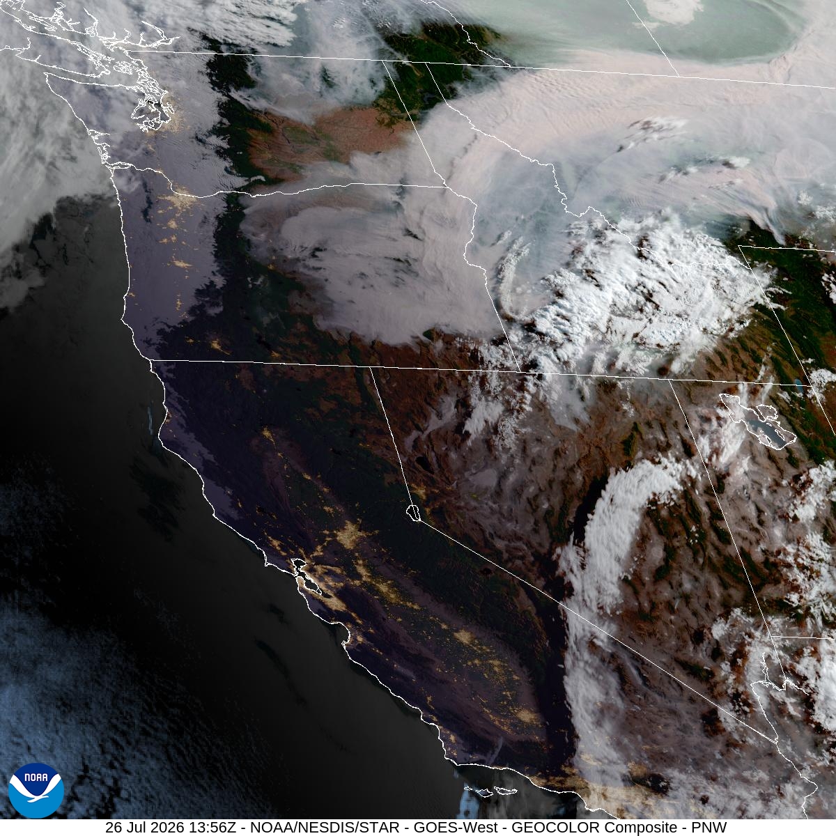
Source: NOAA
| Incident Name | State | Location | Acres | Containment |
|---|---|---|---|---|
| Upper Smith Fire | Idaho | Approx 20 miles northwest of Bonners Ferry, ID, up the Smith Creek Drainage | 1184 | 15% |
| Claremont Fire | Idaho | 1 mile NE of Boise, Idaho | 6606 | 90% |
| Duncan | Idaho | 50 Miles SW of Mountain Home, ID | 16362 | 70% |
| Cascade | Idaho | 22 miles East of Lowell, Idaho | 280 | NA |
| Elder 1 Fire | Montana | 7 Miles west of Frenchtown, MT | 200 | NA |
| Fox Fire | Oregon | 12 Miles NE of Huntington, OR | 21874 | 0% |
| Powder River Fire | Oregon | 4 Miles SW of RICHLAND, OR | 21058 | 52% |
| Second Flat | Oregon | Six miles NE of Riley, OR | 25188 | 5% |
| Hay Creek Complex | Oregon | Gilliam, Sherman and Wasco counties, Oregon | 181821 | 50% |
| Anthony Fire | Oregon | 34 miles north of Baker City, OR | 2514 | 64% |
| Burnt Creek Fire | Oregon | 23 Miles N of Enterprise, OR | 3015 | 0% |
| Shingle Fire | Oregon | 14 Miles SE of Mitchell, OR | 30000 | 0% |
| Akawa Butte Fire | Oregon | 13 Miles NE of Sisters, OR | 27222 | 5% |
| Coyote Fire | Oregon | 5 miles south of Post, OR | 17589 | 45% |
| Salmon Fire | Oregon | 34 Miles SW of Baker City, OR | 1426 | 60% |
| Grasshopper | Oregon | 7 miles west of Wamic | 4500 | 0% |
| Rowe Creek Complex | Oregon | 10 Miles S of Fossil, OR | 208759 | 31% |
| Horse Ridge Fire | Oregon | 25 Miles East of Pendleton, OR | 831 | 60% |
| Hagen Fire | Oregon | 26 Miles East of Pendleton, OR | 24038 | NA |
| Paradise Fire | Oregon | 15 miles south of Pendleton Oregon | 740 | NA |
| Bologna Fire | Oregon | 7 miles northeast of Kimberly, OR | 2421 | 35% |
| East Evans Creek Fire | Oregon | 14 Miles NE of Rogue River | 15580 | 54% |
| GREEN MOUNTAIN | Oregon | 11 Miles N of Prineville, OR | 400 | 0% |
| Brewer Fire | Oregon | 15 Miles E of Madras, OR | 37319 | 5% |
| Bald Mountain | Oregon | 50 Miles SE of Burns, OR | 150 | 0% |
| Stubble | Oregon | 15 Miles SW of Lawen, OR | 10229 | 0% |
| Crater | Oregon | 35 Miles S of Burns, OR | 700 | 0% |
| Jackass Butte | Oregon | 40 Miles S of Burns, OR | 1000 | 0% |
| Henry Fire | Oregon | 5 Miles S of PAULINA GUARD STATION, OR | 24996 | 16% |
| Egypt Fire | Oregon | 12 Miles N of Riley, OR | 4595 | 68% |
| North Cayuse Fire | Oregon | 15 miles east of Pendleton, OR. | 4887 | 91% |
| Kaiser Canyon Fire | Washington | Nespelem Okanogan / Kaiser Canyon | 121417 | 9% |
| Modrite Fire | Washington | 17 Miles SW of Inchelium, WA | 9107 | 63% |
| Bradeen Hill Fire | Washington | Gifford, WA | 449 | 0% |
| Railroad Fire | Washington | 9 miles N of Mattawa, WA | 8380 | 35% |
| Little Giant Fire | Washington | 30 miles NW of Leavenworth, WA | 19134 | 0% |
| Border 2 Fire | Washington | 20 Miles NE of Marblemount, WA | 325 | 0% |
| Luna Fire | Washington | 10 Miles north of Newhalem, WA | 125 | 0% |
| Mount Tom Creek Fire | Washington | Olympic National Park | 69 | 75% |
| Royal Lake | Washington | 8 miles NW of Othello, WA | 1995 | 95% |
| B and O Fire | Washington | 23200 Block of State Route 20, Okanogan, Washington | 2762 | 95% |
| Chelan Hills | Washington | 1 Mile N of Orando | 9735 | 75% |
Tags: smoke forecast