
Smoke Forecast for Friday, July 26, 2024 9:00 AM
Current Conditions
The Montana Department of Environmental Quality has issued an air quality alert for Beaverhead, Deer Lodge, Granite, Madison, Ravalli, and Silver Bow counties in effect until 8AM 7/27/2024 due to elevated particulate levels from wildfire smoke.
Wildfires in Idaho grew significantly on Thursday. The Thunder fire south of Salmon and the WYE MCRD fire west of Hamilton continue to send smoke up and over the Bitterroot Mountains, into Southwest Montana. There are now five active wildfires burning in Oregon that are at least 100,000 acres in size. These fires continue to send smoke into parts of the Northern Rockies and Montana.
The Miller Peak fire outside Missoula has burned over 2,600 acres with 25% containment. Gusty winds and warm temperatures could lead to increased fire activity again on Friday.
See the latest Air Resource Advisor report from the Miller Peak fire here
At 8:00 AM Friday, Libby, Columbia Falls, Cut Bank, Choteau, Seeley Lake, Frenchtown, Missoula, Helena, Dillon, Bozeman, Great Falls, Lewistown, Havre, Malta, Sidney, Glendive, Miles City, Broadus, and Billings were enduring Moderate air quality. Butte was experiencing air that is considered Unhealthy For Sensitive Groups. Hamilton was experiencing air that is considered Very Unhealthy.
Friday morning’s satellite reveals heavy smoke wildfires burning in Idaho, drifting across the border into Southwest Montana.
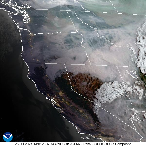
Source: NOAA
Forecast
Cooler, drier air continues to mix into the Northern Rockies. Numerous active fires burning in Idaho will continue to send smoke over the border into parts of Southwest Montana. Breezy conditions in the afternoon will help fan the flames on existing wildfires, while allowing surface smoke concentrations to improve slightly.
A zonal flow will keep temperatures closer to average this weekend. Breezy westerly winds will likely lead to additional fire growth on existing fires and continue to send plumes of smoke into the Bitterroot Valley and parts of Southwest Montana through the weekend.
Next week, a ridge of high pressure builds back over the area. Unseasonably warm temperatures are expected to return with afternoon highs well into the 90s. The combination of near-record warmth, dry fuels, and gusty afternoon winds will lead to additional fire growth. Unfortunately, rain chances will be few and far between over the next week.
By Saturday afternoon, the HRRR smoke model shows strong westerly winds pumping heavy smoke from regional wildfires into Montana. The Bitterroot Valley will continue to see some of the worst air quality from this pattern.
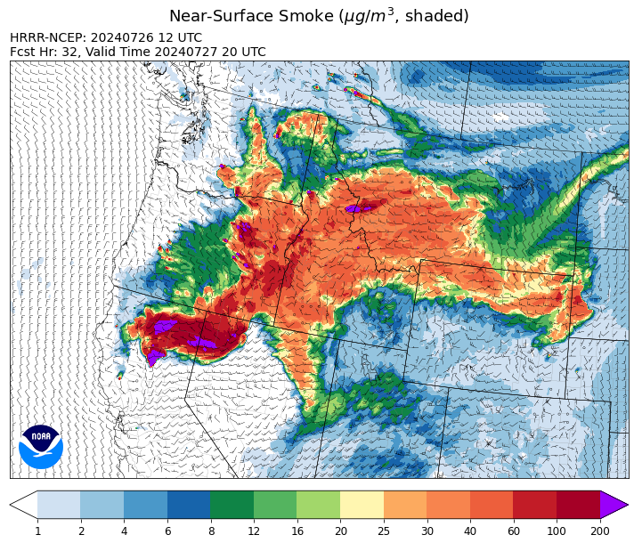
Source: HRRR Smoke
Conditions can change quickly as weather could stimulate active fires and the likelihood of new starts increases. Please keep track of concentrations at todaysair.mtdeq.us or the Fire and Smoke Map.
Current Wildfires
|
Incident |
State |
location |
acres |
containment |
|
Wolf Creek Fire - IDPAF |
Idaho |
West facing slope of West Mountain, Council Ranger District, Payette National Forest |
400 |
0% |
|
Limepoint Fire - IDPAF |
Idaho |
Hells Canyon, Council Ranger District Payette National Forest |
600 |
0% |
|
Bench Lake Fire - IDSTF |
Idaho |
8 miles south of Stanley, Idaho |
2,595 |
58% |
|
Texas Fire - IDIDS |
Idaho |
Two miles East of Kendrick, ID |
1,582 |
90% |
|
Thunder Fire - IDSCF |
Idaho, United States |
12 miles south, southwest of Salmon, ID |
2,200 |
0% |
|
Horse Gulch Fire - MTHLF |
Montana |
1/2 mile north of Canyon Ferry Dam near Helena, Montana |
15,167 |
95% |
|
Miller Peak Fire - MTLNF |
Montana |
7 miles southeast of Missoula |
2,660 |
25% |
|
Butler Creek Fire - MTMTS |
Montana |
5 miles northwest of Missoula |
307 |
70% |
|
Blacktail Canyon - MTBDF |
Montana |
4 miles southeast of Butte, MT |
80 |
NA |
|
Deadman Fire - MTMTS |
Montana |
Approx 17 mi south of Birney and north of the Tongue River Reservoir in Rosebud and Big Horn Counties |
47,827 |
NA |
|
Durkee Fire - ORVAD |
Oregon |
5 miles southwest of Durkee, Oregon |
288,690 |
20% |
|
Lone Rock Fire - ORPRD |
Oregon |
Lone Rock OR stretching to west of HWY 207 and south to HWY 19 |
136,561 |
45% |
|
Whisky Creek Fire - ORMHF |
Oregon |
East fork of Herman Creek, 6 miles SE of Cascade Locks, OR |
856 |
0% |
|
Falls Fire - ORMAF |
Oregon |
20 miles NW of Burns |
141,926 |
50% |
|
Telephone Fire - ORMAF |
Oregon |
16 miles north east of Burns, Oregon |
12,180 |
0% |
|
Jack Saddle - ORUPF |
Oregon |
Approximately 10 miles SSE of Dorena, Oregon |
1,001 |
0% |
|
Mineral - ORUPF |
Oregon |
Approximately 7 miles southeast of Dorena, Oregon |
665 |
0% |
|
Quartz - ORUPF |
Oregon |
10 miles SSE Dorena, OR |
759 |
0% |
|
Puddin - ORUPF |
Oregon |
Approximately 13 miles southeast of Dorena, OR |
210 |
0% |
|
Adam Mountain - ORUPF |
Oregon |
Approximately 6 miles southeast of Dorena, Oregon |
1,421 |
0% |
|
Clark 900 - OR770S |
Oregon |
37 miles northeast of Roseburg, OR |
1,421 |
0% |
|
Cottage Grove - Lane 1 - OR77S |
Oregon |
Approximately 16 miles SE of Springfield, OR |
1,421 |
0% |
|
Battle Mountain Complex - OR97S |
Oregon |
West and south of Ukiah, OR |
140,879 |
5% |
|
Microwave Tower Fire - OR95S |
Oregon |
5 miles WSW of Mosier, OR |
762 |
53% |
|
Badland Complex 2024 - ORVAD |
Oregon |
Baker County, Oregon |
51,196 |
0% |
|
Ore Fire - ORWIF |
Oregon |
7 Miles NE of Blue River, OR |
1,050 |
3% |
|
Cow Valley Fire - ORVAD |
Oregon |
West of Brogan and Northwest of Vale |
133,490 |
99% |
|
Diamond Complex - ORUPF |
Oregon |
18 miles southwest of Chemult, Oregon |
4,156 |
3% |
|
Courtrock Fire - OR95S |
Oregon |
7.1 Miles S. of Monument, Oregon |
5,170 |
0% |
|
Red Fire - ORDEF |
Oregon |
Diamond Peak Wilderness |
389 |
0% |
|
Homestead Complex - ORUPF |
Oregon |
NA |
1,044 |
0% |
|
Boneyard Fire - OR95S |
Oregon |
10.4 Miles north of Monument, Oregon |
49,716 |
3% |
|
Salt Creek - OR710S |
Oregon |
5 miles SSW of Butte Falls, Oregon |
4,102 |
100% |
|
Larch Creek Fire - OR95S |
Oregon |
Friend, OR, a rural community |
18,286 |
81% |
|
Retreat - WASES |
Washington |
11 Miles East of Rimrock Lake, WA |
13,183 |
0% |
|
Pioneer - WASES |
Washington |
10 miles southeast of Stehekin, WA |
31,583 |
14% |
|
Easy Fire - WAOWF |
Washington |
17 air miles west of Mazama, WA |
397 |
0% |
|
Big Horn Fire - WASES |
Washington |
7 miles SE of Bickleton Washington, and 7 miles N of Roosevelt, Washington |
32,886 |
5% |
|
Bridge Creek - WACOA |
Washington |
North of Bridge Creek, East of Elbow River |
3,903 |
20% |
|
Pincer Two Fire - WAMSF |
Washington |
Johanasburg Mountain. 1 Mile East of Mineral Park C.G. |
82 |
0% |
|
Cougar Creek Fire - WASES |
Washington |
1 mile west of Hwy 129 and Grand Ronde river intersection |
14,026 |
26% |
|
Swawilla Fire - WACOA |
Washington |
North of Columbia River, East of Swawilla Basin, West of Hwy 21 |
30,667 |
10% |
|
Black Canyon - WASES |
Washington |
10 Miles NW, Naches, WA |
11,099 |
0% |
Source: Inciweb
Tags: Smoke Forecast 2024