
Smoke Forecast for Friday, July 25, 2025 9:30 AM
Current Conditions
Friday will likely be the warmest day of the next week. Expect more active fire behavior and increased smoke production on regional wildfires to end the week.
On Thursday, a new wildfire started in the Bitterroot National Forest, just west of Hamilton. The Lost Horse fire exhibited active fire behavior on Thursday and is around 50 acres. Firefighters are getting a better handle on the Deer fire burning just southeast of Missoula. It has burned 75 acres and is 60% contained. Smoke production and fire activity increased again on Thursday on the Big Bear and Rush fires burning in the Bitterroot Range of central Idaho, just southwest of the Bitterroot Valley. The Big Bear fire has grown to 9,520 acres and is 75% contained while the Rush fire is up to 7,002 acres and is 50% contained. Firefighters have begun to get a better handle on the Cram fire burning near Madras, Oregon. It has burned through 95,736 acres and is now 77% contained.
At 9:00 AM Friday, Great Falls and Missoula’s air quality is Moderate.
By Saturday afternoon, the HRRR smoke model shows some light surface smoke over southwest Montana from regional wildfires.
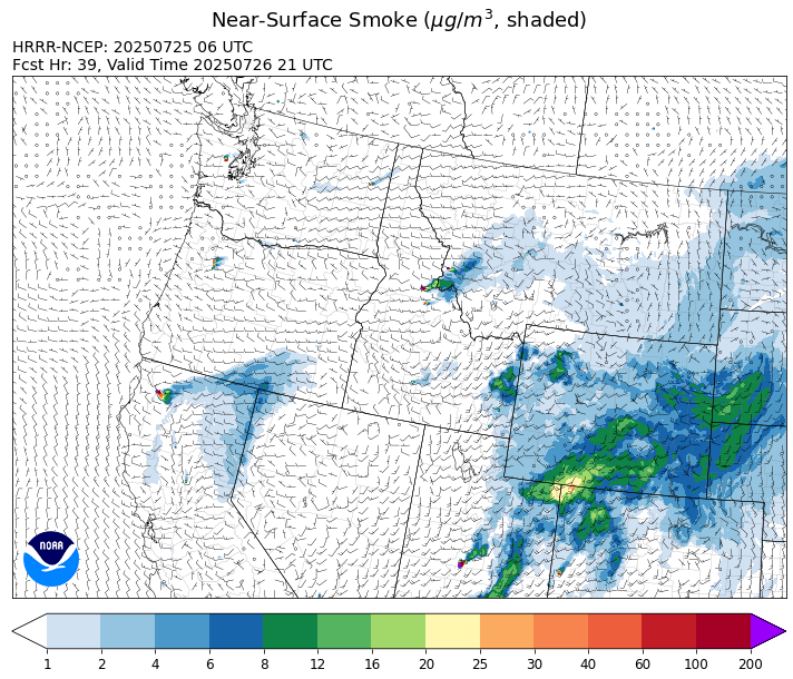
Source: HRRR-smoke
Forecast
Friday will likely be the warmest day of the next week. As a result, fire behavior on many regional wildfires is expected to pick up again Friday afternoon. The Lost Horse fire started on Thursday, just outside Hamilton. Westerly transport winds should send a plume of smoke across portions of Ravalli, Granite, and Powell Counties, particularly by Friday afternoon. Despite firefighters making good progress on containment, the Big Bear and Rush fires burning in central Idaho were active again on Thursday. These fires will continue to send smoke into Ravalli and Beaverhead Counties again on Friday.
Montana will be under the influence of a southwesterly flow starting Friday. This will pump moist, monsoonal air into the state. This pattern will coincide with the arrival of a series of weak disturbances marching across Montana. These features will combine with seasonably warm air to produce nearly daily shower and thunderstorm chances.
By next week, a large trough will push inland across the Pacific Northwest. This will provide additional lift and instability to the region, potentially enhancing rainfall rates. At the same time, monsoonal moisture is expected to continue streaming north into the Treasure State. This pattern should moderate fire behavior on regional blazes, decrease smoke production, and produce beneficial precipitation. Apart from southwest Montana, fuel moistures remain anomalously wet throughout most of the state thanks to timely rainfall. Stay tuned!
Conditions can change quickly as weather could stimulate active fires and the likelihood of new starts increases. Please keep track of concentrations at todaysair.mtdeq.us or the Fire and Smoke Map.
Friday morning’s satellite shows some light smoke over southwest Montana from regional wildfires.
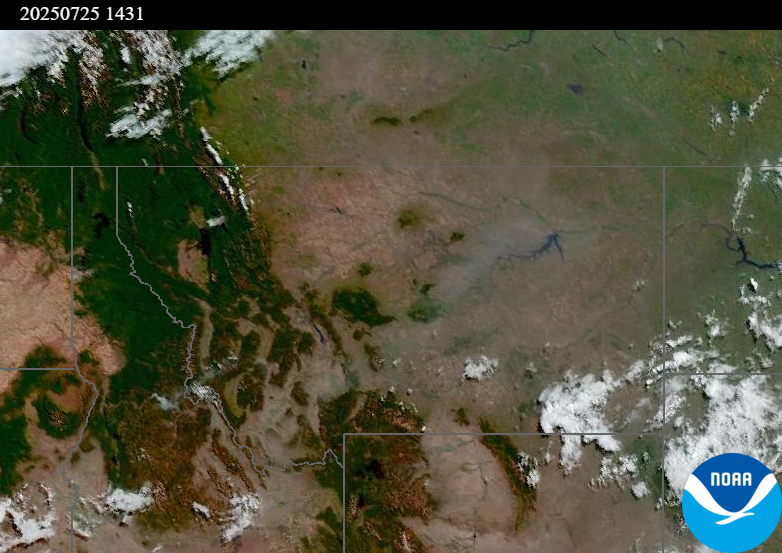
Source: NOAA
| Incident Name | State | Location | Acres | Containment |
|---|---|---|---|---|
| Rush | Idaho | Frank Church-River of No Return Wilderness | 7002 | NA |
| Big Bear | Idaho | Frank Church-River of No Return Wilderness | 9520 | NA |
| Shingle | Idaho | NA | 100 | NA |
| Post Fire | Idaho | North of US Highway 12, East of Mocus Point Trailhead | 144 | 94% |
| Deer Fire | Montana | NA | 75 | 60% |
| Green Mountain Fire & Garnet Fire | Montana | NA | 70 | 75% |
| Observation Point Fire | Montana, United States | Located up Lost Horse drainage on the Darby-Sula Ranger District, one mile SW of the Coyote Coulee Trailhead. | 91 | NA |
| Butte Creek | Oregon | 2 miles west of Simnasho, Oregon | 2071 | 30% |
| Cram Fire | Oregon | 15 miles northeast of Madras, OR | 95736 | 77% |
| Hagelstein Fire | Oregon | 14 miles north of Klamath Falls, Oregon | 669 | 75% |
| Elk Fire | Oregon | 7 miles SW of Beatty, Oregon | 2637 | 95% |
| Snyder Canyon | Washington | 3 Miles Northwest of Klickitat, WA | 53 | 13% |
| Lake Spokane Fire | Washington | 12 Miles NW of Spokane, WA | 2579 | 22% |
| Bear Gulch Fire | Washington | 10 Miles NW of Hoodsport, WA | 869 | 10% |
| Burdoin Fire | Washington | 2.5 miles east of White Salmon | 11248 | 13% |
| Pomas Fire | Washington | Approximately 36 miles northwest of Entiat, WA | 3444 | NA |
| Hope Fire | Washington | Approximately 15 Miles north of Kettle Falls, WA and 5 miles southwest of Northport, WA | 7880 | 75% |
Tags: Smoke Forecast 2025