
Smoke Forecast for Thursday, July 25, 2024 9:30 AM
Current Conditions
Most of the Canadian wildfire smoke has exited the state. However, fires in Washington and Oregon grew significantly over the past 24-hours, and westerly winds continue to send that smoke into Montana.
The Miller Peak fire outside Missoula has burned over 2,600 acres with 25% containment. Gusty winds and warm temperatures could lead to increased fire activity again on Thursday.
See the latest Air Resource Advisor report from the Miller Peak fire here
At 9:00 AM Thursday, Columbia Falls, Thompson Falls, Great Falls, Cut Bank, Missoula, Dillon, West Yellowstone, Malta, Billings, Miles City, Sidney, Glendive, and Broadus were enduring Moderate air quality. Seeley Lake and Libby were experiencing air that is considered Unhealthy For Sensitive Groups.
Thursday morning’s satellite reveals smoke from wildfires burning in California, Washington, and Oregon drifting into Western Montana.
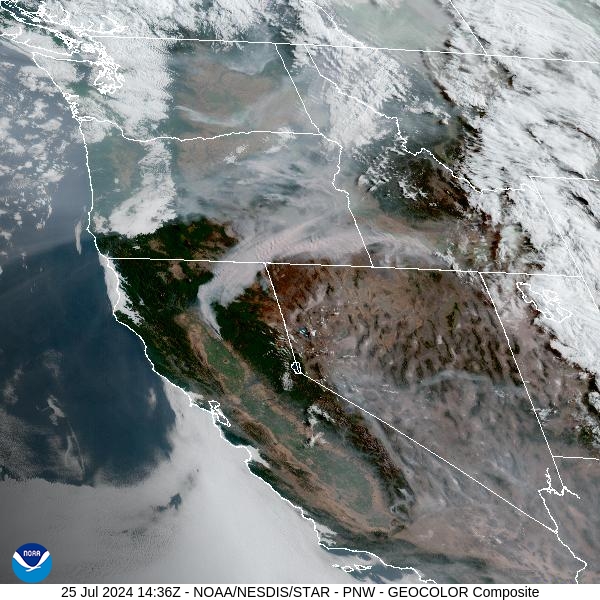
Source: NOAA
Forecast
For the first time in about three weeks, temperatures will return closer to normal. However, strong westerly winds will continue to fan the flames on existing wildfires in the region. The gusty winds will help to mix out much of the surface smoke during the day. However, winds will ease in the evening, allowing wildfire smoke to pool and drain into adjacent valleys.
Showers and storms will develop again Thursday afternoon along and east of I-15. A few of the storms could become severe with strong, damaging wind gusts. Considering how dry it’s been across the Northern Rockies, any lightning has the potential to start new wildfires.
Wednesday evening’s storms produced hundreds of lightning strikes over Western Montana. We won’t know the full extent of the damage for another day or two, but the lightning likely started numerous new fires.
By Friday afternoon, the HRRR smoke model shows strong westerly winds pumping smoke from regional wildfires into Montana.
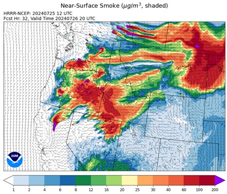
Source: HRRR Smoke
Conditions can change quickly as weather could stimulate active fires and the likelihood of new starts increases. Please keep track of concentrations at todaysair.mtdeq.us or the Fire and Smoke Map.
Current Wildfires
|
Incident |
State |
location |
acres |
containment |
|
Bench Lake Fire - IDSTF |
Idaho |
8 miles south of Stanley, Idaho |
2,595 |
45% |
|
Texas Fire - IDIDS |
Idaho |
Two miles East of Kendrick, ID |
1,582 |
90% |
|
Elk Creek - IDNCF |
Idaho |
5 miles South of Elk River Idaho |
2 |
NA |
|
Horse Gulch Fire - MTHLF |
Montana |
1/2 mile north of Canyon Ferry Dam near Helena, Montana |
15,167 |
95% |
|
Miller Peak Fire - MTLNF |
Montana |
7 miles southeast of Missoula |
2,631 |
25% |
|
Butler Creek Fire - MTMTS |
Montana |
5 miles northwest of Missoula |
307 |
70% |
|
Blacktail Canyon - MTBDF |
Montana |
4 miles southeast of Butte, MT |
80 |
NA |
|
Deadman Fire - MTMTS |
Montana |
Approx 17 mi south of Birney and north of the Tongue River Reservoir in Rosebud and Big Horn Counties |
47,827 |
NA |
|
Homestead Complex - ORUPF |
Oregon |
NA |
1,044 |
0% |
|
Durkee Fire - ORVAD |
Oregon |
5 miles southwest of Durkee, Oregon |
268,492 |
0% |
|
Telephone Fire - ORMAF |
Oregon |
16 miles north east of Burns, Oregon |
9,000 |
0% |
|
Pyramid Fire - ORWIF |
Oregon |
East of the Middle Santiam Wilderness |
615 |
0% |
|
Lone Rock Fire - ORPRD |
Oregon |
Lonerock Oregon stretching West of HWY 207 |
136,377 |
40% |
|
Falls Fire - ORMAF |
Oregon |
20 miles NW of Burns |
140,422 |
50% |
|
Red Fire - ORDEF |
Oregon |
Diamond Peak Wilderness |
389 |
0% |
|
Oakridge Lightning Fires 2024 - ORWIF |
Oregon |
NA |
NA |
0% |
|
Badland Complex 2024 - ORVAD |
Oregon |
Baker County, Oregon |
58,944 |
0% |
|
Diamond Complex - ORUPF |
Oregon |
18 miles southwest of Chemult, Oregon |
3,764 |
3% |
|
Cow Valley Fire - ORVAD |
Oregon |
West of Brogan and Northwest of Vale |
133,490 |
91% |
|
Boneyard Fire - OR95S |
Oregon |
10.4 Miles north of Monument, Oregon |
49,716 |
3% |
|
Clark 900 - OR770S |
Oregon |
37 miles northeast of Roseburg, OR |
841 |
0% |
|
Battle Mountain Complex - OR97S |
Oregon |
West and south of Ukiah, OR |
63,985 |
5% |
|
Cottage Grove - Lane 1 - OR77S |
Oregon |
Approximately 16 miles SE of Springfield, OR |
1,296 |
10% |
|
Microwave Tower Fire - OR95S |
Oregon |
5 miles WSW of Mosier, OR |
704 |
14% |
|
Whisky Creek Fire - ORMHF |
Oregon |
East fork of Herman Creek, 6 miles SE of Cascade Locks, OR |
288 |
0% |
|
Ore Fire - ORWIF |
Oregon |
7 Miles NE of Blue River, OR |
860 |
2% |
|
Salt Creek - OR710S |
Oregon |
5 miles SSW of Butte Falls, Oregon |
4,102 |
100% |
|
Larch Creek Fire - OR95S |
Oregon |
Friend, OR, a rural community |
18,286 |
81% |
|
Pioneer - WASES |
Washington |
10 miles southeast of Stehekin, WA |
30,667 |
14% |
|
Easy Fire - WAOWF |
Washington |
17 air miles west of Mazama, WA |
397 |
0% |
|
Black Canyon - WASES |
Washington |
10 Miles NW, Naches, WA |
7,500 |
0% |
|
Cougar Creek Fire - WASES |
Washington |
1 mile west of Hwy 129 and Grand Ronde river intersection |
13,511 |
26% |
|
Big Horn Fire - WASES |
Washington |
7 miles SE of Bickleton Washington, and 7 miles N of Roosevelt, Washington |
32,886 |
5% |
|
Swawilla Fire - WACOA |
Washington |
North of Columbia River, East of Swawilla Basin, West of Hwy 21 |
12,634 |
0% |
|
Pincer Two Fire - WAMSF |
Washington |
NA |
10 |
0% |
|
Bridge Creek - WACOA |
Washington |
North of Bridge Creek, East of Elbow River |
2,398 |
0% |
Source: Inciweb
Tags: Smoke Forecast 2024