
Smoke Forecast for Wednesday, July 24, 2024 9:00 AM
Current Conditions
Canadian wildfire smoke will gradually mix out of northern and eastern sections of the state on Wednesday. An approaching trough will help to spread smoke from Pacific Northwest wildfires into Western Montana in the next 24-hours.
The Miller Peak fire outside Missoula has expanded to just over 2,600 acres, with 25 percent containment. Active fire behavior is expected by Wednesday afternoon because of stronger winds along and ahead of a front.
See the latest Air Resource Advisor report from the Miller Peak fire here
At 8:00 AM Wednesday, Libby, Thompson Falls, Columbia Falls, Cut Bank, Choteau, Great Falls, Seeley Lake, Frenchtown, Missoula, Sleeping Giant, Helena, Hamilton, Butte, Dillon, West Yellowstone, Bozeman, Lewistown, Billings, Malta, Glendive, Sidney, Miles City were enduring Moderate air quality. Broadus was experiencing air that is considered Unhealthy For Sensitive Groups.
Wednesday morning’s satellite shows smoke from Oregon, Washington, and Idaho wildfires moving into the state.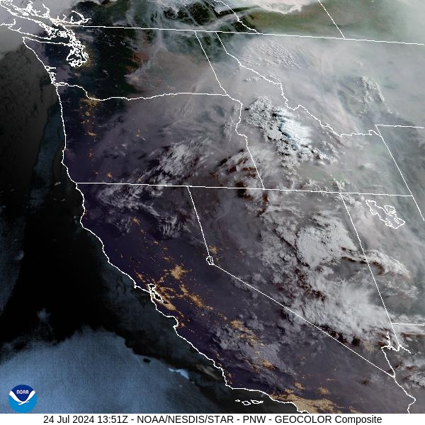
Source: NOAA
Forecast
Widespread thunderstorms are possible by Wednesday afternoon as a trough of low pressure sweeps across the state. Monsoonal moisture will arrive, and send dew point values into the 50s, providing plenty of juice for the storms to feed from. The combination of dry fuels, unseasonably warm air, and gusty winds will produce critical fire weather for much of the region. Strong outflow winds from thunderstorms could produce wind gusts over 50 MPH, exacerbating fire conditions in the area and allowing existing wildfires to quickly expand. The thunderstorms will be accompanied by frequent lightning, bringing the threat for new fires to start.
A second area of storms will begin over Western Montana close to sunset. These storms will be a bit more widespread, providing many of the same fire weather concerns. By midday Thursday, a stronger cool front will sweep across the area. It will produce gusty winds through Friday. Fortunately, it will also provide higher humidity levels and more seasonable temperatures, easing fire weather concerns a bit. Temperatures will trend closer to average by Friday and into the weekend, with highs in the 80s for the valleys.
By midday Thursday, the HRRR smoke model shows a trough bringing smoke from Oregon, Washington, and Idaho into the state.
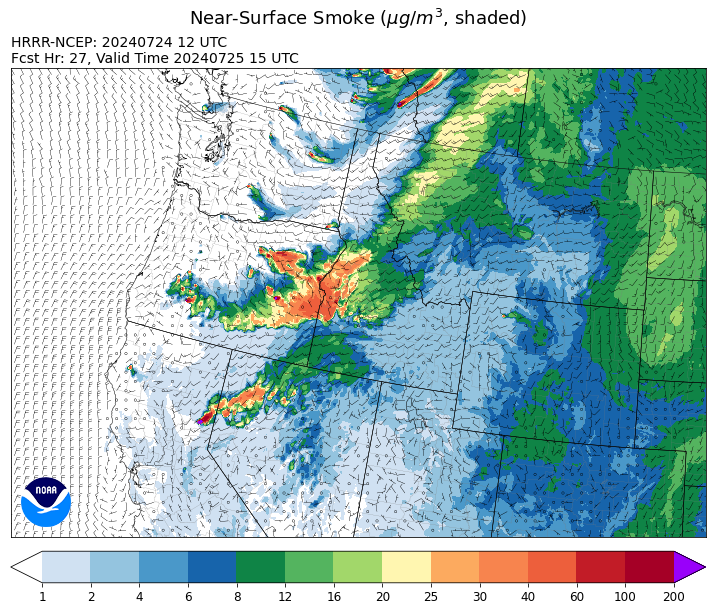
Source: HRRR Smoke
Conditions can change quickly as weather could stimulate active fires and the likelihood of new starts increases. Please keep track of concentrations at todaysair.mtdeq.us or the Fire and Smoke Map.
Current Wildfires
|
Incident |
State |
location |
acres |
containment |
|
Bench Lake Fire - IDSTF |
Idaho |
8 miles south of Stanley, Idaho |
2,595 |
34% |
|
Texas Fire - IDIDS |
Idaho |
Two miles East of Kendrick, ID |
1,582 |
80% |
|
Elk Creek - IDNCF |
Idaho |
5 miles South of Elk River Idaho |
2 |
NA |
|
Deadman Fire - MTMTS |
Montana |
Approx 17 mi south of Birney and north of the Tongue River Reservoir in Rosebud and Big Horn Counties |
47,827 |
NA |
|
Horse Gulch Fire - MTHLF |
Montana |
5 miles south of York |
15,167 |
95% |
|
Miller Peak Fire - MTLNF |
Montana |
7 miles southeast of Missoula |
2,609 |
25% |
|
Butler Creek Fire - MTMTS |
Montana |
7 miles northwest of Missoula |
307 |
15% |
|
Blacktail Canyon - MTBDF |
Montana |
4 miles southeast of Butte, MT |
76 |
NA |
|
Oakridge Lightning Fires 2024 - ORWIF |
Oregon |
NA |
NA |
0% |
|
Red Fire - ORDEF |
Oregon |
Diamond Peak Wilderness |
262 |
0% |
|
Boneyard Fire - OR95S |
Oregon |
10.4 Miles north of Monument, Oregon |
39,646 |
2% |
|
Diamond Complex - ORUPF |
Oregon |
18 miles southwest of Chemult, Oregon |
3,352 |
3% |
|
Durkee Fire - ORVAD |
Oregon |
5 miles southwest of Durkee, Oregon |
244,842 |
0% |
|
Lone Rock Fire - ORPRD |
Oregon |
Lonerock Oregon stretching West of HWY 207 |
134,752 |
40% |
|
Cow Valley Fire - ORVAD |
Oregon |
West of Brogan and Northwest of Vale |
133,490 |
91% |
|
Battle Mountain Complex - OR97S |
Oregon |
West and south of Ukiah, OR |
52,832 |
5% |
|
Cottage Grove - Lane 1 - OR77S |
Oregon |
Approximately 16 miles SE of Springfield, OR |
1,090 |
10% |
|
Homestead Complex - ORUPF |
Oregon |
NA |
767 |
0% |
|
Ore Fire - ORWIF |
Oregon |
7 Miles NE of Blue River, OR |
747 |
0% |
|
Telephone Fire - ORMAF |
Oregon |
15 miles north of Burns, Oregon |
5,000 |
0% |
|
Whisky Creek Fire - ORMHF |
Oregon |
East fork of Herman Creek, 6 miles SE of Cascade Locks, OR |
155 |
0% |
|
Falls Fire - ORMAF |
Oregon |
20 miles NW of Burns |
139,507 |
40% |
|
Pyramid Fire - ORWIF |
Oregon |
East of the Middle Santiam Wilderness |
535 |
0% |
|
Microwave Tower - OR954S |
Oregon |
5 miles WSW of Mosier, OR |
150 |
0% |
|
Salt Creek - OR710S |
Oregon |
5 miles SSW of Butte Falls, Oregon |
4,102 |
100% |
|
Larch Creek Fire - OR95S |
Oregon |
Friend, OR, a rural community |
18,286 |
81% |
|
Pioneer - WASES |
Washington |
10 miles southeast of Stehekin, WA |
30,667 |
14% |
|
Easy Fire - WAOWF |
Washington |
17 air miles west of Mazama, WA |
354 |
0% |
|
Cougar Creek Fire - WASES |
Washington |
1 mile west of Hwy 129 and Grand Ronde river intersection |
12,429 |
23% |
|
Bridge Creek - WACOA |
Washington |
North of Bridge Creek, East of Elbow River |
2,398 |
0% |
|
Swawilla Fire - WACOA |
Washington |
North of Columbia River, East of Swawilla Basin, West of Hwy 21 |
12,634 |
0% |
|
Black Canyon - WASES |
Washington |
10 Miles NW, Naches, WA |
6,500 |
0% |
|
Pincer Two Fire - WAMSF |
Washington |
NA |
10 |
0% |
Source: Inciweb
Tags: Smoke Forecast 2024