
Smoke Forecast for Wednesday, July 23, 2025 9:00 AM
Current Conditions
Clouds, precipitation, and cooler weather moderated fire behavior on many regional wildfires on Tuesday. Warmer weather and sunshine is drying out fuels and producing more active fire behavior on Wednesday.
The Deer fire burning just southeast of Missoula has burned 75 acres and is 25% contained. Fire activity was dampened by the cooler weather and rain that fell on Tuesday. Tuesday’s precipitation largely missed the Big Bear and Rush fires burning in the Bitterroot Range of central Idaho, just southwest of the Bitterroot Valley. The Big Bear fire has grown to 8,955 acres and the Rush fire is up to 6,791 acres. The Cram fire burning near Madras, Oregon is now the largest fire in the country. It has burned through 95,736 acres and is now 73% contained.
At 9:00 AM Wednesday, Great Falls, Lewistown, Cut Bank, Havre, and Malta's air quality is Moderate.
By midday Thursday, the HRRR smoke model shows some light surface smoke over southwest Montana from wildfires burning over central Idaho.
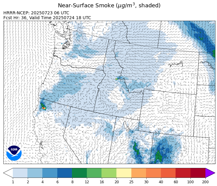
Source: HRRR-smoke
Forecast
The northeasterly flow gradually eases on Wednesday. This will reduce the amount of surface smoke from Canadian wildfires over northeast Montana. After a cool stretch of weather, a zonal flow returns on Wednesday, and it will allow temperatures to warm up closer to average. A weak system will move across the Northern Rockies by the afternoon, and it should be enough to kick off a few showers, primarily over the mountains.
A westerly flow will persist across the Treasure State between Thursday and Friday. The seasonable temperatures and dry conditions should lead to more active fire behavior on the Big Bear and Rush fires burning in central Idaho. Smoke models continue to advertise the potential for some light surface smoke from these blazes reaching southwest Montana at times.
A trough shifts across the state by this weekend. At the same time, a southwesterly flow will pump moist air into the state. The combination of these two features should be enough to kick off some scattered showers and thunderstorms. Montana’s fire season has been relatively tame thus far because of a couple of factors. First, there haven’t been any prolonged heat waves to dry out fuel moistures. Second, much of the state has received timely precipitation through the first half of summer, mitigating the risk for large wildfires on the landscape. There’s still a lot of fire season to go, but thankfully this pattern should continue until at least the first part of August. Stay tuned!
Conditions can change quickly as weather could stimulate active fires and the likelihood of new starts increases. Please keep track of concentrations at todaysair.mtdeq.us or the Fire and Smoke Map.
Wednesday morning’s satellite shows widespread cloud cover and a few storms over eastern Montana behind a departing area of low pressure.
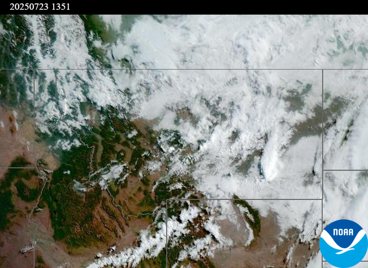
Source: NOAA
| Incident Name | State | Location | Acres | Containment |
|---|---|---|---|---|
| Rush | Idaho | Frank Church-River of No Return Wilderness | 6791 | NA |
| Big Bear | Idaho | Frank Church-River of No Return Wilderness | 8955 | NA |
| Deer Fire | Montana | NA | 75 | 25% |
| Elk Fire | Oregon | 7 miles SW of Beatty, Oregon | 2637 | 95% |
| Hagelstein Fire | Oregon | 14 miles north of Klamath Falls, Oregon | 669 | 75% |
| Cram Fire | Oregon | 15 miles north of Madras, OR | 95736 | 73% |
| Butte Creek | Oregon | 1.5 miles west of Simnasho, Oregon | 2050 | 30% |
| Burdoin Fire | Washington | 2.5 miles east of White Salmon | 10973 | 5% |
| Hope Fire | Washington | Approximately 15 Miles north of Kettle Falls, WA and 5 miles southwest of Northport, WA | 7891 | 65% |
| Lake Spokane Fire | Washington | 12 Miles NW of Spokane, WA | 2338 | 16% |
| Pomas Fire | Washington | Approximately 36 miles northwest of Entiat, WA | 3429 | NA |
| Bear Gulch Fire | Washington | 10 Miles NW of Hoodsport, WA | 762 | 19% |
Tags: Smoke Forecast 2025