
Smoke Forecast for Tuesday, July 23, 2024 9:00 AM
Current Conditions
The Montana Department of Environmental Quality has issued an airquality alert for Big Horn, Blaine, Carter, Custer, Daniels, Dawson, Fallon, Garfield, Glacier, Hill, Liberty, McCone, Phillips, Powder River, Prairie, Richland, Roosevelt, Rosebud, Sheridan, Toole, Treasure, Valley, and Wibaux counties in effect until 8AM 7/24/2024 elevated particulate levels from wildfire smoke This alert will be updated again at 8AM 7/24/2024.
Smoke from Canadian wildfires is slowly pulling away from western portions of the state. However, numerous active, large wildfires burning in Washington, Idaho, and Oregon will spread smoke into Montana ahead of an approaching trough.
The Miller Peak fire outside Missoula has grown to around 2,500 acres with 25% containment. Unseasonably warm temperatures, dry fuels, and gusty winds will generate active fire behavior again on Tuesday.
Fire crews continue to mop things up on the Horse Gulch fire outside Helena. The fire has burned more than 15,000 acres but is 95% contained.
See the latest Air Resource Advisor report from the Miller Peak fire here
At 8:00 AM Monday, Columbia Falls, Thompson Falls, Choteau, Seeley Lake, Frenchtown, Missoula, Hamilton, Butte, Helena, Sleeping Giant, Great Falls, Dillon, West Yellowstone, Bozeman, Lewistown, Billings, Malta, and Glendive were enduring Moderate air quality. Libby, Cut Bank, Miles City, Sidney, and Broadus were experiencing air that is considered Unhealthy For Sensitive Groups.
Tuesday morning’s satellite shows smoke from Oregon, Washington, and Idaho wildfires moving into the state.
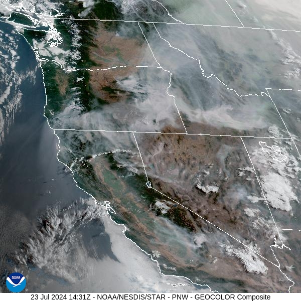
Source: NOAA
Forecast
Winds have begun to shift over eastern parts of the state. That will gradually push areas of thick Canadian wildfire smoke out of the area. Unseasonably warm air, dry fuels, and gusty winds will lead to additional growth on existing wildfires. Scattered thunderstorms will be possible by Tuesday afternoon and evening, primarily over southern parts of the state. Gusty winds will be possible with these storms, and any wildfires adjacent to these storms will experience erratic fire behavior as a result. Considering how dry the fuels are over the area, any lightning from these storms will have the potential to start new wildfires.
A series of weak cold fronts will move across the area between Wednesday and Thursday. The combination of gusty winds and low humidity levels will allow existing wildfires to continue to grow. More seasonable temperatures are anticipated for Friday into the weekend. The combination of cooler temperatures and slightly higher humidity should ease fire behavior. Unfortunately, there isn’t a soaking rain in the forecast for at least another 7-10 days.
By Wednesday afternoon, the HRRR smoke model shows a trough bringing smoke from Oregon, Washinton, and Idaho into the state.
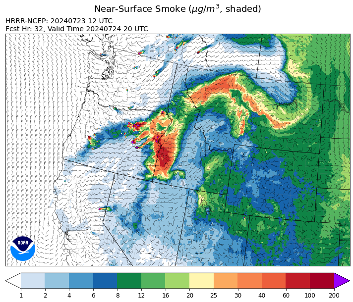
Source: HRRR Smoke
Conditions can change quickly as weather could stimulate active fires and the likelihood of new starts increases. Please keep track of concentrations at todaysair.mtdeq.us or the Fire and Smoke Map.
Current Wildfires
|
Incident |
State |
location |
acres |
containment |
|
Bench Lake Fire - IDSTF |
Idaho |
8 miles south of Stanley, Idaho |
2,595 |
23% |
|
Texas Fire - IDIDS |
Idaho |
Two miles East of Kendrick, ID |
1,565 |
70% |
|
Elk Creek - IDNCF |
Idaho |
5 miles South of Elk River Idaho |
2 |
NA |
|
Deadman Fire - MTMTS |
Montana |
Approx 17 mi south of Birney and north of the Tongue River Reservoir in Rosebud and Big Horn Counties |
47,827 |
0% |
|
Butler Creek Fire - MTMTS |
Montana |
7 miles northwest of Missoula |
307 |
15% |
|
Blacktail Canyon - MTBDF |
Montana |
4 miles southeast of Butte, MT |
76 |
NA |
|
Horse Gulch Fire - MTHLF |
Montana |
5 miles south of York |
15,167 |
95% |
|
Miller Peak Fire - MTLNF |
Montana |
7 miles southeast of Missoula |
2,581 |
25% |
|
Durkee Fire - ORVAD |
Oregon |
5 miles southwest of Durkee, Oregon |
239,255 |
0% |
|
Telephone Fire - ORMAF |
Oregon |
15 miles north of Burns, Oregon |
5000 |
0% |
|
Falls Fire - ORMAF |
Oregon |
20 miles NW of Burns |
139,507 |
40% |
|
Boneyard Fire - OR95S |
Oregon |
10.4 Miles north of Monument, Oregon |
14,602 |
2% |
|
Cow Valley Fire - ORVAD |
Oregon |
West of Brogan and Northwest of Vale |
133,490 |
78% |
|
Lone Rock Fire - ORPRD |
Oregon |
Lonerock Oregon stretching West of HWY 207 |
131,407 |
40% |
|
Diamond Complex - ORUPF |
Oregon |
Diamond Lake Ranger District of the Umpqua National Forest |
3,021 |
3% |
|
Battle Mountain Complex - OR97S |
Oregon |
West and south of Ukiah, OR |
43,067 |
3% |
|
Homestead Complex - ORUPF |
Oregon |
NA |
1,000 |
0% |
|
Lane 1 - OR77S |
Oregon |
Approximately 15 miles SE of Springfield, OR |
768 |
10% |
|
Ore Fire - ORWIF |
Oregon |
7 Miles NE of Blue River, OR |
645 |
0% |
|
Pyramid Fire - ORWIF |
Oregon |
East of the Middle Santiam Wilderness |
535 |
0% |
|
Salt Creek - OR710S |
Oregon |
5 miles SSW of Butte Falls, Oregon |
4,102 |
100% |
|
Red Fire - ORDEF |
Oregon |
Diamond Peak Wilderness |
256 |
0% |
|
Larch Creek Fire - OR95S |
Oregon |
Friend, OR, a rural community |
18,286 |
81% |
|
Pioneer - WASES |
Washington |
10 miles southeast of Stehekin, WA |
30,352 |
14% |
|
Easy Fire - WAOWF |
Washington |
17 air miles west of Mazama, WA |
345 |
0% |
|
Cougar Creek Fire - WASES |
Washington |
1 mile west of Hwy 129 and Grand Ronde river intersection |
10,766 |
23% |
|
Bridge Creek - WACOA |
Washington |
North of Bridge Creek, East of Elbow River |
2,398 |
0% |
|
Swawilla Fire - WACOA |
Washington |
North of Columbia River, East of Swawilla Basin, West of Hwy 21 |
7,291 |
0% |
|
Pincer Two Fire - WAMSF |
Washington |
NA |
10 |
0% |
Source: Inciweb
Tags: Smoke Forecast 2024