
Smoke Forecast for Tuesday, July 22, 2025 9:30 AM
Current Conditions
Smoke from Canadian wildfires continues to pour south into portions of northeast Montana early Tuesday. Low pressure is bringing another round of rain to mainly northern sections of the state.
Clouds, cooler air, and precipitation on Monday moderated regional fire behavior. The Deer fire burning just southeast of Missoula has already burned 100 acres. The Big Bear and Rush fires burning in the Bitterroot Range of central Idaho, just southwest of the Bitterroot Valley, continue to burn. The Big Bear fire has grown to 7,041 acres and the Rush fire is up to 6,082 acres. The Cram fire burning near Madras, Oregon is now the largest fire in the country. It has burned through 95,736 acres.
At 9:00 AM Tuesday, Malta's air is Unhealthy. Havre and Miles City's air is Unhealthy for Sensitive Groups. Sidney, Billings, Lewistown, and Sleeping Giant's air quality is Moderate.
By midday Wednesday, the HRRR smoke model shows some light surface smoke over northeast Montana from Canadian wildfires.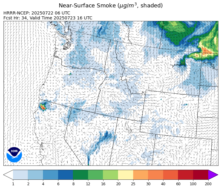
Source: HRRR-smoke
Forecast
Another area of low pressure will march across the state on Tuesday. It will focus precipitation across northern sections of Montana. Thunderstorms will develop by Tuesday afternoon and many of the same areas in northwest Montana that received heavy precipitation on Monday could see a repeat on Tuesday.
A northeasterly flow is dragging down smoke from Canadian wildfires into places like Havre, Malta, and Miles City early Tuesday. Better afternoon mixing and a subtle wind shift should provide improving air quality for the region by Tuesday afternoon.
A zonal flow develops Wednesday across the region and continues until Friday. This will promote a drying and warming trend across the Treasure State. It will also lead to more active fire weather, particularly across central Idaho where the Big Bear and Rush fires are burning. These fires will likely send smoke into parts of Ravalli and Beaverhead Counties by the end of the week.
A southwesterly flow returns by this weekend. There should be enough moisture and instability around to generate afternoon thunderstorms, particularly in the mountains. The good news about the summer thus far is that there haven’t been any prolonged hot and dry stretches to promote active fire behavior. That should continue at least until the first of August. Stay tuned!
Conditions can change quickly as weather could stimulate active fires and the likelihood of new starts increases. Please keep track of concentrations at todaysair.mtdeq.us or the Fire and Smoke Map.
Tuesday morning’s satellite shows widespread cloud cover thanks to an area of low pressure. Some smoke is visible across northeast Montana from Canadian wildfires.
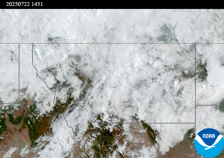
Source: NOAA
| Incident Name | State | Location | Acres | Containment |
|---|---|---|---|---|
| Big Bear | Idaho | Frank Church-River of No Return Wilderness | 7041 | NA |
| Rush | Idaho | Frank Church-River of No Return Wilderness | 6082 | NA |
| Deer Fire | Montana | NA | 75 | NA |
| Green Mountain Fire & Garnet Fire | Montana | NA | 70 | 75% |
| Butte Creek | Oregon | 5 miles northeast of Simnasho, OR | 2000 | 30% |
| Cram Fire | Oregon | 15 miles north of Madras, OR | 95736 | 73% |
| Elk Fire | Oregon | 7 miles SW of Beatty, Oregon | 2637 | 88% |
| Hagelstein Fire | Oregon | 14 miles north of Klamath Falls, Oregon | 669 | 62% |
| Bear Gulch Fire | Washington | The fire is burning on a steep, rocky slope near the Mt. Rose Trailhead along the Lake Cushman Corridor (FS-24). | 652 | 19% |
| Burdoin Fire | Washington | 2.5 miles east of White Salmon | 10973 | 0% |
| Hope Fire | Washington | Approximately 15 Miles north of Kettle Falls, WA and 5 miles southwest of Northport, WA | 7891 | 55% |
| Lake Spokane Fire | Washington | Stevens County, WA | 2338 | 16% |
| Pomas Fire | Washington | Approximately 36 miles northwest of Entiat, WA | 3429 | NA |
Tags: Smoke Forecast 2025