
Smoke Forecast for Monday, July 22, 2024 9:00 AM
Current Conditions
The Montana Department of Environmental Quality has issued an air quality alert for Blaine, Broadwater, Cascade, Chouteau, Daniels, Dawson, Deer Lodge, Fergus, Garfield, Glacier, Granite, Hill, Jefferson, Judith Basin, Lewis and Clark, Liberty, McCone, Meagher, Missoula, Petroleum, Phillips, Pondera, Powell, Prairie, Ravalli, Richland, Roosevelt, Sheridan, Silver Bow, Teton, Toole, Valley, and Wibaux counties in effect until 7AM 7/23/2024 due to elevated particulate levels from wildfire smoke This alert will be updated again at 8AM 7/23/2024.
Overall, smoke production from the Horse Gulch fire outside of Helena is minimal. The fire is nearly fully contained with only a few minor hotspots. The Miller Peak fire south of Missoula saw moderate fire activity over the weekend. Unseasonably warm temperatures and gusty winds could increase fire activity, particularly by Monday afternoon. The Blacktail Canyon fire south of Butte continues to expand and will likely grow in the coming days.
Wildfire smoke from Canada arrived on Sunday in Montana as winds shifted to the northeast. This smoke will mix with smoke from regional wildfires, contributing to our deteriorating air quality.
See the latest Air Resource Advisor report from the Horse Gulch fire here
See the latest Air Resource Advisor report from the Miller Peak fire here
At 8:00 AM Monday, Libby, Frenchtown, Cut Bank, Thompson Falls, Seeley Lake, Hamilton, Butte, Dillon, West Yellowstone, Bozeman, Choteau, Billings, Broadus, Miles City, Glendive, Sidney, and Malta were enduring Moderate air quality. Missoula, Helena, Sleeping Giant, Great Falls, and Lewistown were experiencing air that is considered Unhealthy For Sensitive Groups.
Monday morning’s satellite shows smoke from regional wildfires and from Canada moving into the state.
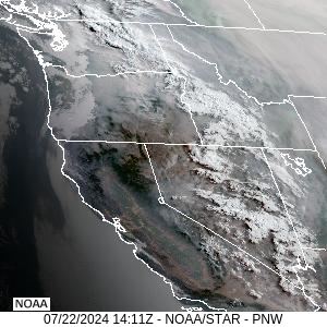
Source: NOAA
Forecast
Wildfire smoke from Canada and regional fires will impact much of the state, particularly east of the Continental Divide through at least Wednesday. By Thursday, the ridge of high pressure begins to break down. The good news about the front is that it will help to scour out surface smoke, thanks to gusty winds. The bad news is that the increased winds will likely lead to explosive growth on existing wildfires.
Showers and thunderstorms will move across the region Wednesday and Thursday. Considering how hot and dry it’s been of late, new fire starts from lightning will be of particular concern. A cold front will begin to increase the winds over Western Montana beginning late Tuesday and Wednesday.
By Tuesday afternoon, the HRRR smoke model shows a trough beginning to push Canadian wildfire smoke out of the area.
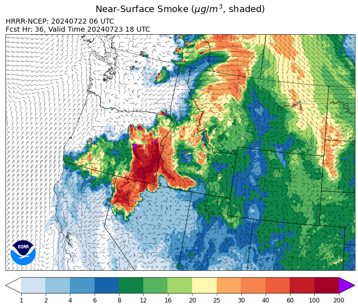
Source: HRRR Smoke
Conditions can change quickly as weather could stimulate active fires and the likelihood of new starts increases. Please keep track of concentrations at todaysair.mtdeq.us or the Fire and Smoke Map.
Current Wildfires
|
Incident |
State |
location |
acres |
containment |
|
Bench Lake Fire - IDSTF |
Idaho |
8 miles south of Stanley, Idaho |
2,567 |
13% |
|
Texas Fire - IDIDS |
Idaho |
Two miles East of Kendrick, ID |
1,575 |
60% |
|
Elk Creek - IDNCF |
Idaho |
5 miles South of Elk River Idaho |
2 |
NA |
|
Blacktail Canyon - MTBDF |
Montana |
4 miles southeast of Butte, MT |
68 |
NA |
|
Horse Gulch Fire - MTHLF |
Montana |
5 miles south of York |
15,167 |
92% |
|
Miller Peak Fire - MTLNF |
Montana |
7 miles southeast of Missoula |
2,481 |
10% |
|
Deadman Fire - MTMTS |
Montana |
Approx 17 mi south of Birney and north of the Tongue River Reservoir in Rosebud and Big Horn Counties |
47,827 |
0% |
|
Falls Fire - ORMAF |
Oregon |
20 miles NW of Burns |
132,951 |
16% |
|
Durkee Fire - ORVAD |
Oregon |
5 miles southwest of Durkee, Oregon |
173,758 |
0% |
|
Lone Rock Fire - ORPRD |
Oregon |
Lonerock Oregon stretching West of HWY 207 |
116,563 |
40% |
|
Boneyard Fire - OR95S |
Oregon |
10.4 Miles north of Monument, Oregon |
14,602 |
0% |
|
Cow Valley Fire - ORVAD |
Oregon |
West of Brogan and Northwest of Vale |
133,490 |
78% |
|
Lane 1 - OR77S |
Oregon |
Approximately 15 miles SE of Springfield, OR |
768 |
10% |
|
Red Fire - ORDEF |
Oregon |
Diamond Peak Wilderness |
350 |
0% |
|
Ore Fire - ORWIF |
Oregon |
7 Miles NE of Blue River, OR |
645 |
0% |
|
Diamond Complex - ORUPF |
Oregon |
NA |
2,816 |
NA |
|
Pyramid Fire - ORWIF |
Oregon |
East of the Middle Santiam Wilderness |
500 |
0% |
|
Battle Mountain Complex - OR97S |
Oregon |
West of Ukiah, OR |
6,408 |
0% |
|
Larch Creek Fire - OR95S |
Oregon |
Friend, OR, a rural community |
18,286 |
81% |
|
Salt Creek - OR710S |
Oregon |
5 miles SSW of Butte Falls, Oregon |
4,102 |
84% |
|
Easy Fire - WAOWF |
Washington |
17 air miles west of Mazama, WA |
300 |
0% |
|
Pioneer - WASES |
Washington |
10 miles southeast of Stehekin, WA |
29,995 |
14% |
|
Cougar Creek Fire - WASES |
Washington |
1 mile west of Hwy 129 and Grand Ronde river intersection |
8,271 |
23% |
|
Swawilla Fire - WACOA |
Washington |
North of Columbia River, East of Swawilla Basin, West of Hwy 21 |
5,500 |
0% |
|
Pincer Two Fire - WAMSF |
Washington |
NA |
10 |
0% |
|
Bridge Creek - WACOA |
Washington |
North of Bridge Creek, East of Elbow River |
1,100 |
0% |
Source: Inciweb
Tags: Smoke Forecast 2024