
Smoke Forecast for Monday, July 21, 2025 9:30 AM
Current Conditions
A trough swings across the state on Monday. It will bring some precipitation to the Deer fire, just southeast of Missoula, which began on Friday.
Clouds and light precipitation helped to moderate fire behavior on regional wildfires on Sunday. The Deer fire is just 5 miles southeast of Missoula. It started on Friday and has burned 75 acres. There is a staff of 124 assigned to the blaze. The Big Bear and Rush fires burning in the Bitterroot Range of central Idaho, just southwest of the Bitterroot Valley, continue to burn. The Big Bear fire has grown to 7,041 acres and the Rush fire is up to 6,082 acres. The Cram fire burning near Madras, Oregon is now the largest fire in the country. It has burned through 95,748 acres.
At 9:00 AM Monday, Libby’s air quality is Moderate.
By Tuesday morning, the HRRR smoke model shows increasing surface smoke over northeast Montana from Canadian wildfires.
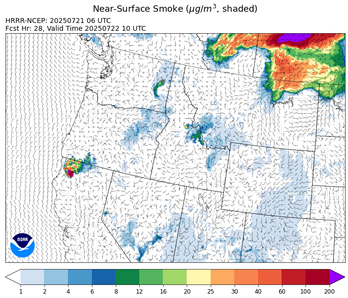
Source: HRRR-smoke
Forecast
A trough of low pressure will march across the Treasure State to start the week. It will produce some beneficial rainfall, particularly across northwest Montana. Some rain will fall on the Deer fire outside Missoula, and this should temper fire behavior and limit smoke production. Afternoon high temperatures on Monday will be 5-10 degrees below normal. The combination of clouds, cooler temperatures, and precipitation will help to moderate fire behavior on regional wildfires. Additional precipitation is expected on Tuesday, with most of the showers and thunderstorms focused on northwest Montana. A northeasterly flow will drag down some surface smoke into the area from Canadian wildfires, particularly over northeast Montana on Tuesday.
A zonal flow returns to the region starting Wednesday. This will allow temperatures to climb and humidity levels to drop. The pattern will lead to more active fire behavior and increased smoke production on regional wildfires. Afternoon highs will climb into the upper 80s and low 90s in most valley locations through Friday.
A trough will shift into the Northern Rockies by this weekend. It will likely bring another round of showers and thunderstorms to the Treasure State. Moisture will be limited, so widespread precipitation looks unlikely with this system. Stay tuned!
Conditions can change quickly as weather could stimulate active fires and the likelihood of new starts increases. Please keep track of concentrations at todaysair.mtdeq.us or the Fire and Smoke Map.
Monday morning’s satellite shows increasing clouds across the Treasure State thanks to an approaching area of low pressure. Some wildfire smoke is visible across southern Canada.
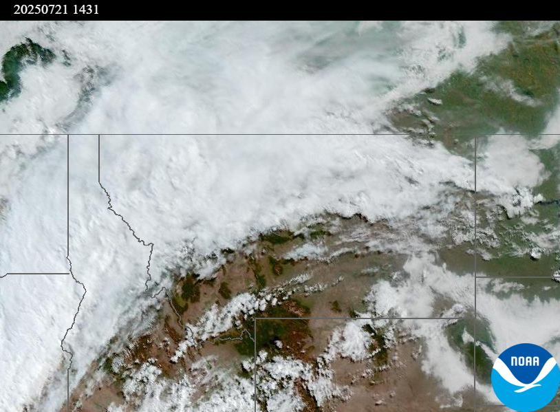
Source: NOAA
| Incident Name | State | Location | Acres | Containment |
|---|---|---|---|---|
| Big Bear - IDPAF | Idaho | Frank Church-River of No Return Wilderness | 7041 | NA |
| Rush - IDPAF | Idaho | Frank Church-River of No Return Wilderness | 6082 | NA |
| Cherry Fire - IDPDS | Idaho | Approximately 1 mile northeast of Deary | 113 | 80% |
| Deer Fire - MTLNF | Montana | NA | 75 | NA |
| Green Mountain Fire & Garnet Fire - MTMTS | Montana | NA | 70 | 75% |
| Elk Fire - OR98S | Oregon | 7 miles SW of Beatty, Oregon | 2637 | 88% |
| Hagelstein Fire - OR98S | Oregon | 14 miles north of Klamath Falls, Oregon | 669 | 45% |
| Cram Fire - ORPRD | Oregon | 15 miles north of Madras, OR | 95748 | 73% |
| Bear Gulch Fire - WAOLF | Washington | The fire is burning on a steep, rocky slope near the Mt. Rose Trailhead along the Lake Cushman Corridor (FS-24). | 652 | 19% |
| Lake Spokane Fire - WAWAS | Washington | Stevens County, WA | 1751 | 1% |
| Hope Fire - WANES | Washington | Approximately 15 Miles north of Kettle Falls, WA and 5 miles southwest of Northport, WA | 7891 | 45% |
| Pomas Fire 2025 - WAOWF | Washington | Approximately 36 miles northwest of Entiat, WA | 3530 | NA |
| Burdoin Fire - WACWC - WACWC | Washington | NA | 8776 | 0% |
Tags: Smoke Forecast 2025