
Smoke Forecast for Friday, July 19, 2024 10:00 AM
Current Conditions
Overall, smoke production from regional fires continues to increase thanks to unseasonably warm temperatures, dry fuels, and low relative humidity. Closer to Helena, the Horse Gulch Fire experienced limited growth on Thursday, with some burning on the north side of the blaze. Containment on that fire is now up to 40%. Outside Missoula, the Miller Peak fire experienced moderate fire activity on Thursday with minimal growth.
Numerous regional wildfires have grown considerably in the last 48-hours, pumping smoke into much of Montana. Additionally, dry and wet thunderstorms were responsible for hundreds of lightning strikes across Washington, Oregon, Idaho, and Montana between Wednesday and Thursday. This lightning has already led to numerous new fires across the area.
See the latest Air Resource Advisor report from the Horse Gulch fire here
See the latest Air Resource Advisor report from the Miller Peak fire here
At 9:00 AM Friday, Columbia Falls, Choteau, Seeley Lake, Helena, Sleeping Giant, Frenchtown, Great Falls, Butte, West Yellowstone, Bozeman, Billings, Broadus, Broadus, Lewistown, Sidney, Glendive, and Cut Banke were enduring Moderate air quality. Missoula was experiencing air that is considered Unhealthy For Sensitive Groups.
Friday morning’s satellite reveals smoke pouring into Western Montana from fires burning in and out of the state.
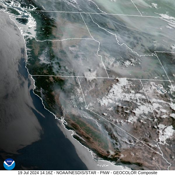
Source: NOAA
Forecast
Excessive heat is anticipated Friday and into the weekend. The combination of heat, low humidity, and dry fuels will lead to additional fire growth. Additionally, thunderstorms were responsible for hundreds of lightning strikes across the region between Wednesday and Thursday. The weather pattern will allow several of the new fires to experience rapid growth in the coming days, leading to deteriorating air quality.
Easterly winds are still forecasted to impact the region starting Saturday night through Monday. It will bring smoke from the Miller Peak fire into portions of the Bitterroot and Missoula Valleys, where air quality could be impacted. Additionally, the easterly wind will also impact the other big fires across the state. Depending on fuels and fire behavior, the easterly wind will push smoke from the Horse Gulch fire into places like York and the Helena Valley.
A backdoor cool front will impact the eastern side of the state by this weekend. It will result in Northwest winds and could open the door to smoke from large wildfires burning in Alberta and British Columbia.
By Saturday afternoon, the HRRR smoke model shows smoke from Canadian wildfires drifting south into parts of Eastern Montana.
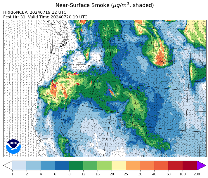
Source: HRRR Smoke
Conditions can change quickly as weather could stimulate active fires and the likelihood of new starts increases. Please keep track of concentrations at todaysair.mtdeq.us or the Fire and Smoke Map.
Current Wildfires
|
Incident |
State |
location |
acres |
containment |
|
Bench Lake Fire - IDSTF |
Idaho |
8 miles south of Stanley, Idaho |
2,037 |
8% |
|
Texas Fire - IDIDS |
Idaho |
Two miles East of Kendrick, ID |
1,556 |
10% |
|
Miller Peak Fire - MTLNF |
Montana |
8 miles southeast of Missoula |
2,035 |
NA |
|
Deadman Fire - MTMTS |
Montana |
Approx 17 mi south of Birney and north of the Tongue River Reservoir in Rosebud and Big Horn Counties |
39,161 |
0% |
|
Larch Creek Fire - OR95S |
Oregon |
Friend, OR, a rural community |
18,286 |
65% |
|
Falls Fire - ORMAF |
Oregon |
20 miles NW of Burns |
114,236 |
10% |
|
Lone Rock Fire - ORPRD |
Oregon |
Lonerock Oregon stretching West of HWY 207 |
83,922 |
40% |
|
Durkee Fire - ORVAD |
Oregon |
5 miles southwest of Durkee, Oregon |
2,699 |
0% |
|
Battle Mountain Complex - OR97S |
Oregon |
West of Ukiah, OR |
1,786 |
0% |
|
Cow Valley Fire - ORVAD |
Oregon |
9 miles east of Ironside, Ore. |
133,408 |
77% |
|
Salt Creek - OR710S |
Oregon |
5 miles SSW of Butte Falls, Oregon |
4,102 |
84% |
|
Pioneer - WASES |
Washington |
10 miles southeast of Stehekin, WA |
25,688 |
14% |
|
Cougar Creek Fire - WASES |
Washington |
1 mile west of Hwy 129 and Grand Ronde river intersection |
4,895 |
0% |
|
Easy Fire - WAOWF |
Washington |
18 air miles west of Mazama, WA |
300 |
0% |
Source: Inciweb
Tags: Smoke Forecast 2024